Bandar-e Lengeh elevation
Bandar-e Lengeh (Hormozgan), Iran elevation is 12 meters and Bandar-e Lengeh elevation in feet is 39 ft above sea level [src 1]. Bandar-e Lengeh is a seat of a second-order administrative division (feature code) with elevation that is 1032 meters (3386 ft) smaller than average city elevation in Iran.
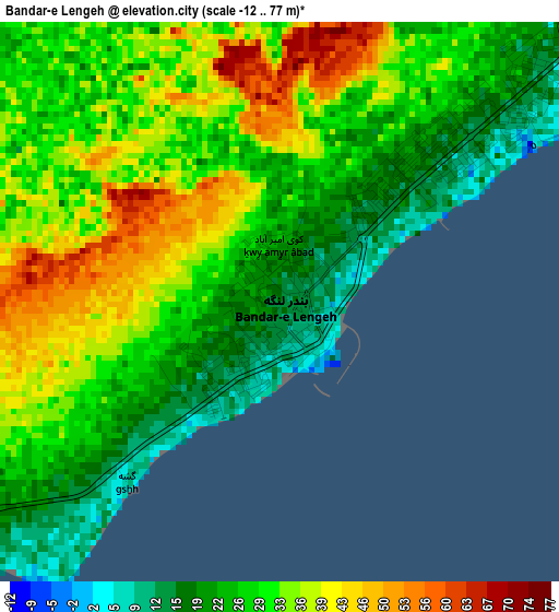
Below is the Elevation map of Bandar-e Lengeh, which displays elevation range with different colors. Scale of the first map is from -12 to 77 m (-39 to 253 ft) with average elevation of 29.7 meters (=97 ft) [note 1]
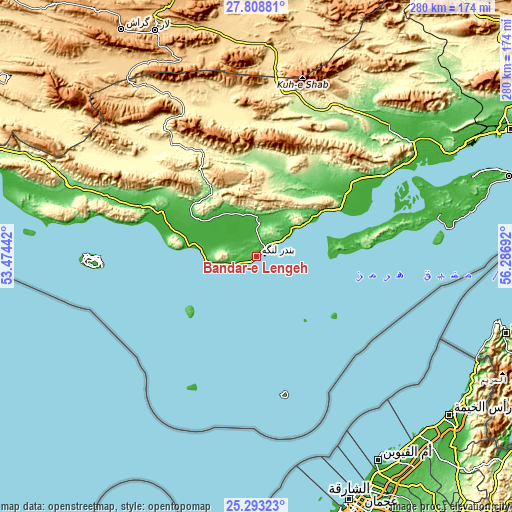
These maps also provides idea of topography and contour of this city, they are displayed at different zoom levels. More info about maps, scale and edge coordinates you can find below images.
| \ | Map #1 | Map #2 | Topo.Map |
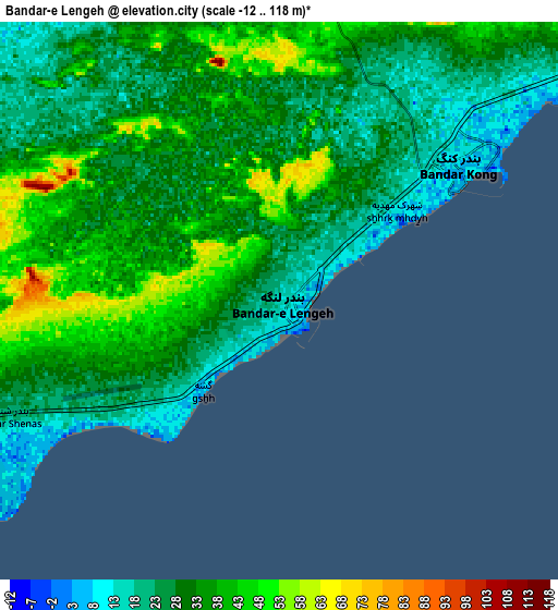
| Scale [m] | -12..77 m | -12..118 m | × |
| Scale [ft] | -39..253 ft | -39..387 ft | × |
| Average | 29.7 m = 97 ft | 30.7 m = 101 ft | × |
| Width | 8.74 km = 5.4 mi | 17.48 km = 10.9 mi | 279.7 km = 173.8 mi |
| Height | 8.74 km = 5.4 mi | 17.48 km = 10.9 mi | 279.7 km = 173.8 mi |
| ↑Max Latitude | 26.597222° | 26.63651° | 27.80881° |
| Latitude at center | 26.55792° | 26.55792° | 26.55792° |
| ↓Min Latitude | 26.518605° | 26.479276° | 25.29323° |
| ← Min Longitude | 54.836725° | 54.792779° | 53.47442° |
| Longitude center | 54.88067° | 54.88067° | 54.88067° |
| →Max Longitude | 54.924615° | 54.968561° | 56.28692° |
Nearby cities:
Cities around Bandar-e Lengeh sort by population:
• Bandar Abbas elevation 9 m
155.5 km,  63°
63°
• Gerāsh 923 m
143.9 km,  329°
329°
• Qeshm 34 m
144.6 km,  72°
72°
• Kīsh 6 m
85.7 km,  269°
269°
• Ḩājjīābād 926 m
219.2 km,  27°
27°
• Khonj 671 m
206 km,  316°
316°
• Ḩājjīābād 1033 m
205.1 km,  347°
347°
• Gāvbandī 58 m
196.7 km,  291°
291°
• Lāmerd 425 m
189.5 km,  297°
297°
• Shahr-e Qadīm-e Lār 818 m
136 km,  336°
336°
• Bastak 403 m
87.6 km, 324°
• Bandar-e Khamīr 16 m
82.5 km, 57°
Multilingual:
 En español:
Bandar-e Lengeh elevación 12 m.
 En France:
Bandar-e Lengeh élévation 12 m.
 Auf Deutsch:
Bandar-e Lengeh höhe über dem Meeresspiegel ist 12 m.

Sources and notes:
- [note 1] Map square and city borders are not equal. Map elevation data is calculated only from area inside that square.
- [src 1] Elevation data from geonames database provided with same terms of usage.
- [src 2] The elevation map of Bandar-e Lengeh is generated using elevation data from NASA's 3 arcsec (90m) resolution SRTM data.
- [src 3] Base (background) map © OpenStreetMap contributors tiles are generated by Geofabrik and OpenTopoMap.
Copyright & License:
This Bandar-e Lengeh Elevation Map is licensed under CC BY-SA. You may reuse any part from this page, if you give a proper credit by linking to this URL:
 More info on terms of use page.