Mīnāb elevation
Mīnāb (Hormozgan), Iran elevation is 43 meters and Mīnāb elevation in feet is 141 ft above sea level [src 1]. Mīnāb is a seat of a second-order administrative division (feature code) with elevation that is 1001 meters (3284 ft) smaller than average city elevation in Iran.
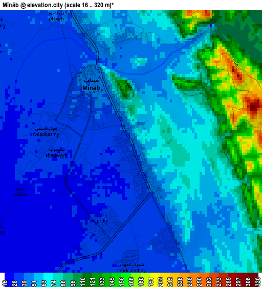
Below is the Elevation map of Mīnāb, which displays elevation range with different colors. Scale of the first map is from 16 to 320 m (52 to 1050 ft) with average elevation of 59.8 meters (=196 ft) [note 1]
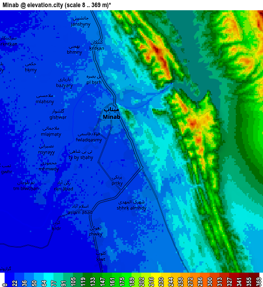
These maps also provides idea of topography and contour of this city, they are displayed at different zoom levels. More info about maps, scale and edge coordinates you can find below images.
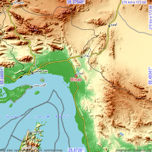
| \ | Map #1 | Map #2 | Topo.Map |
| Scale [m] | 16..320 m | 8..369 m | × |
| Scale [ft] | 52..1050 ft | 26..1211 ft | × |
| Average | 59.8 m = 196 ft | 71.4 m = 234 ft | × |
| Width | 8.7 km = 5.4 mi | 17.39 km = 10.8 mi | 278.3 km = 172.9 mi |
| Height | 8.7 km = 5.4 mi | 17.39 km = 10.8 mi | 278.3 km = 172.9 mi |
| ↑Max Latitude | 27.170143° | 27.209232° | 28.37548° |
| Latitude at center | 27.13104° | 27.13104° | 27.13104° |
| ↓Min Latitude | 27.091923° | 27.052793° | 25.8726° |
| ← Min Longitude | 57.043215° | 56.999269° | 55.68091° |
| Longitude center | 57.08716° | 57.08716° | 57.08716° |
| →Max Longitude | 57.131105° | 57.175051° | 58.49341° |
Nearby cities:
Cities around Mīnāb sort by population:
• Bandar Abbas elevation 9 m
80 km,  274°
274°
• Qeshm 34 m
83.5 km,  255°
255°
• ‘Anbarābād 603 m
167.2 km,  26°
26°
• Arzū’īyeh 1044 m
161.8 km,  334°
334°
• Bandar-e Khamīr 16 m
150.1 km, 262°
• Eslāmābād 487 m
134.2 km,  42°
42°
• Sardasht 727 m
110.4 km,  132°
132°
• Kahnūj 505 m
109.4 km, 33°
• Fāryāb 660 m
108.5 km,  7°
7°
• Qal‘eh Ganj 406 m
89.8 km,  60°
60°
• Manūjān 345 m
51.2 km,  53°
53°
• Rūdān 193 m
36.1 km,  16°
16°
Multilingual:
 En español:
Mīnāb elevación 43 m.
 En France:
Mīnāb élévation 43 m.


Sources and notes:
- [note 1] Map square and city borders are not equal. Map elevation data is calculated only from area inside that square.
- [src 1] Elevation data from geonames database provided with same terms of usage.
- [src 2] The elevation map of Mīnāb is generated using elevation data from NASA's 3 arcsec (90m) resolution SRTM data.
- [src 3] Base (background) map © OpenStreetMap contributors tiles are generated by Geofabrik and OpenTopoMap.
Copyright & License:
This Mīnāb Elevation Map is licensed under CC BY-SA. You may reuse any part from this page, if you give a proper credit by linking to this URL:
 More info on terms of use page.