Pīshvā elevation
Pīshvā (Tehrān), Iran elevation is 953 meters and Pīshvā elevation in feet is 3127 ft above sea level [src 1]. Pīshvā is a seat of a second-order administrative division (feature code) with elevation that is 91 meters (299 ft) smaller than average city elevation in Iran.
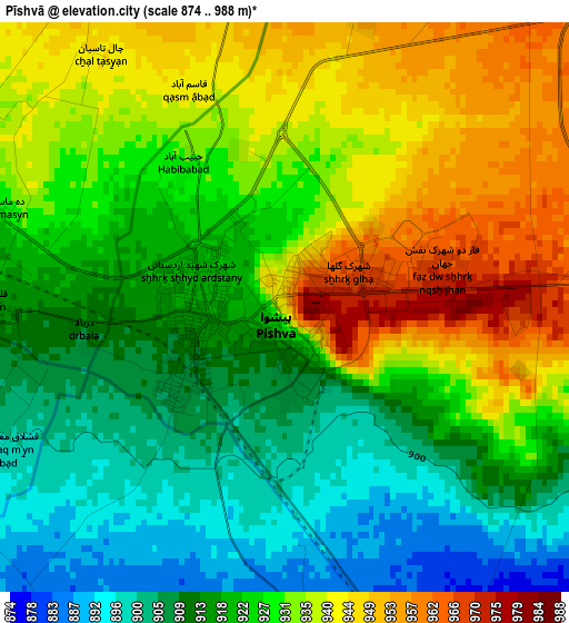
Below is the Elevation map of Pīshvā, which displays elevation range with different colors. Scale of the first map is from 874 to 988 m (2867 to 3241 ft) with average elevation of 925.2 meters (=3035 ft) [note 1]
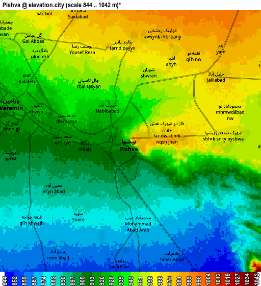
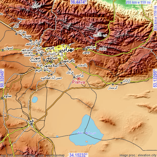
These maps also provides idea of topography and contour of this city, they are displayed at different zoom levels. More info about maps, scale and edge coordinates you can find below images.
| \ | Map #1 | Map #2 | Topo.Map |
| Scale [m] | 874..988 m | 844..1042 m | × |
| Scale [ft] | 2867..3241 ft | 2769..3419 ft | × |
| Average | 925.2 m = 3035 ft | 922 m = 3025 ft | × |
| Width | 7.97 km = 5 mi | 15.95 km = 9.9 mi | 255.2 km = 158.6 mi |
| Height | 7.97 km = 5 mi | 15.95 km = 9.9 mi | 255.2 km = 158.6 mi |
| ↑Max Latitude | 35.343854° | 35.379692° | 36.4474° |
| Latitude at center | 35.308° | 35.308° | 35.308° |
| ↓Min Latitude | 35.27213° | 35.236244° | 34.15232° |
| ← Min Longitude | 51.682755° | 51.638809° | 50.32045° |
| Longitude center | 51.7267° | 51.7267° | 51.7267° |
| →Max Longitude | 51.770645° | 51.814591° | 53.13295° |
Nearby cities:
Cities around Pīshvā sort by population:
• Tehran elevation 1178 m
51.1 km,  327°
327°
• Qarchak 966 m
19.2 km,  314°
314°
• Varāmīn 920 m
7.6 km,  283°
283°
• Īstgāh-e Rāh Āhan-e Garmsār 848 m
53.5 km,  98°
98°
• Eqbālīyeh 879 m
17.3 km,  267°
267°
• Damāvand 1959 m
55.2 km,  34°
34°
• Sharīfābād 1056 m
14.3 km,  21°
21°
• Shahrak-e Emām Ḩasan 991 m
39.9 km,  300°
300°
• Ţāleb ābād 990 m
27.8 km,  320°
320°
• Eslāmshahr 1063 m
52.2 km, 301°
• Rey 1062 m
41 km, 320°
• Pākdasht 1030 m
19.4 km,  348°
348°
Multilingual:
 En español:
Pīshvā elevación 953 m.
 En France:
Pīshvā élévation 953 m.


Sources and notes:
- [note 1] Map square and city borders are not equal. Map elevation data is calculated only from area inside that square.
- [src 1] Elevation data from geonames database provided with same terms of usage.
- [src 2] The elevation map of Pīshvā is generated using elevation data from NASA's 3 arcsec (90m) resolution SRTM data.
- [src 3] Base (background) map © OpenStreetMap contributors tiles are generated by Geofabrik and OpenTopoMap.
Copyright & License:
This Pīshvā Elevation Map is licensed under CC BY-SA. You may reuse any part from this page, if you give a proper credit by linking to this URL:
 More info on terms of use page.