Qūchān elevation
Qūchān (Razavi Khorasan), Iran elevation is 1313 meters and Qūchān elevation in feet is 4308 ft above sea level [src 1]. Qūchān is a seat of a second-order administrative division (feature code) with elevation that is 269 meters (883 ft) bigger than average city elevation in Iran.
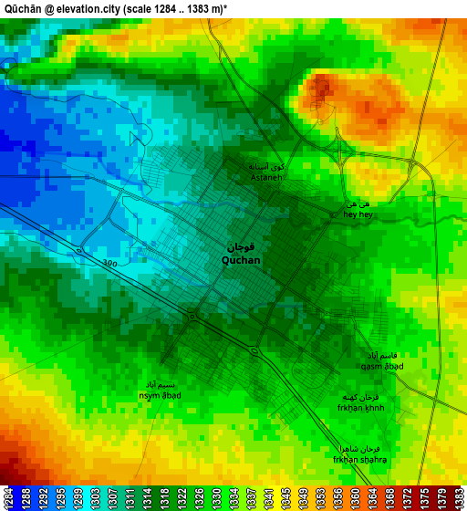
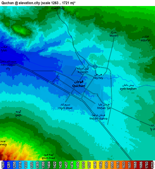
Below is the Elevation map of Qūchān, which displays elevation range with different colors. Scale of the first map is from 1284 to 1383 m (4213 to 4537 ft) with average elevation of 1325.2 meters (=4348 ft) [note 1]
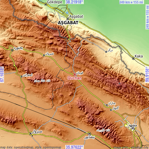
These maps also provides idea of topography and contour of this city, they are displayed at different zoom levels. More info about maps, scale and edge coordinates you can find below images.
| \ | Map #1 | Map #2 | Topo.Map |
| Scale [m] | 1284..1383 m | 1263..1721 m | × |
| Scale [ft] | 4213..4537 ft | 4144..5646 ft | × |
| Average | 1325.2 m = 4348 ft | 1366.2 m = 4482 ft | × |
| Width | 7.79 km = 4.8 mi | 15.59 km = 9.7 mi | 249.4 km = 155 mi |
| Height | 7.79 km = 4.8 mi | 15.59 km = 9.7 mi | 249.4 km = 155 mi |
| ↑Max Latitude | 37.141039° | 37.176062° | 38.21918° |
| Latitude at center | 37.106° | 37.106° | 37.106° |
| ↓Min Latitude | 37.070945° | 37.035873° | 35.97622° |
| ← Min Longitude | 58.465605° | 58.421659° | 57.1033° |
| Longitude center | 58.50955° | 58.50955° | 58.50955° |
| →Max Longitude | 58.553495° | 58.597441° | 59.9158° |
Nearby cities:
Cities around Qūchān sort by population:
• Neyshābūr elevation 1199 m
102.5 km,  165°
165°
• Bojnūrd 1069 m
112.2 km,  291°
291°
• Shīrvān 1093 m
60.7 km,  302°
302°
• Esfarāyen 1253 m
88.7 km,  267°
267°
• Chenārān 1176 m
74.7 km,  133°
133°
• Ţorqabeh 1316 m
117.3 km,  138°
138°
• Kalāt-e Nāderī 881 m
112.1 km,  96°
96°
• Neqāb 1073 m
106.4 km,  245°
245°
• Bozghān 1168 m
91.4 km,  175°
175°
• Solţānābād 1212 m
88.6 km,  208°
208°
• Dargaz 476 m
65 km,  54°
54°
• Fārūj 1183 m
29.3 km, 298°
Multilingual:
 En español:
Qūchān elevación 1313 m.
 En France:
Qūchān élévation 1313 m.


Sources and notes:
- [note 1] Map square and city borders are not equal. Map elevation data is calculated only from area inside that square.
- [src 1] Elevation data from geonames database provided with same terms of usage.
- [src 2] The elevation map of Qūchān is generated using elevation data from NASA's 3 arcsec (90m) resolution SRTM data.
- [src 3] Base (background) map © OpenStreetMap contributors tiles are generated by Geofabrik and OpenTopoMap.
Copyright & License:
This Qūchān Elevation Map is licensed under CC BY-SA. You may reuse any part from this page, if you give a proper credit by linking to this URL:
 More info on terms of use page.