Sāveh elevation
Sāveh (Markazi), Iran elevation is 1008 meters and Sāveh elevation in feet is 3307 ft above sea level [src 1]. Sāveh is a seat of a second-order administrative division (feature code) with elevation that is 36 meters (118 ft) smaller than average city elevation in Iran.
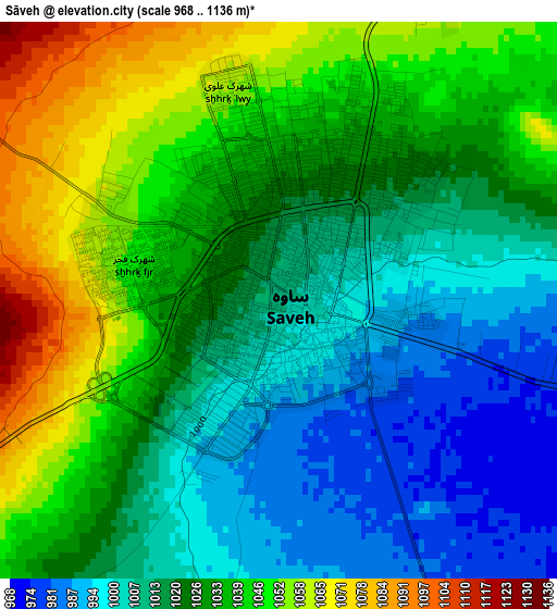
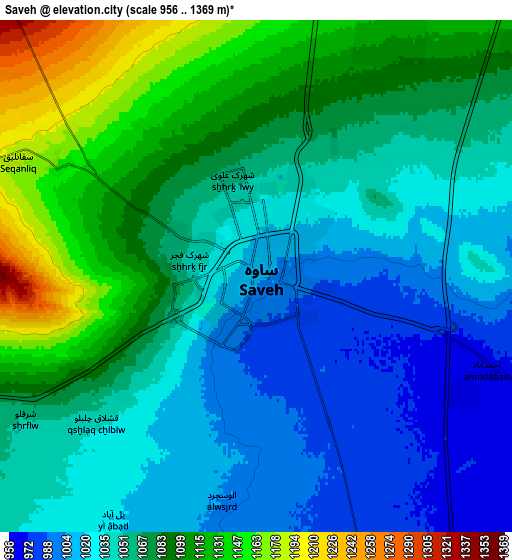
Below is the Elevation map of Sāveh, which displays elevation range with different colors. Scale of the first map is from 968 to 1136 m (3176 to 3727 ft) with average elevation of 1025.9 meters (=3366 ft) [note 1]
These maps also provides idea of topography and contour of this city, they are displayed at different zoom levels. More info about maps, scale and edge coordinates you can find below images.
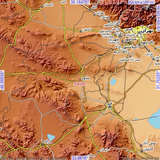
| \ | Map #1 | Map #2 | Topo.Map |
| Scale [m] | 968..1136 m | 956..1369 m | × |
| Scale [ft] | 3176..3727 ft | 3136..4491 ft | × |
| Average | 1025.9 m = 3366 ft | 1061.4 m = 3482 ft | × |
| Width | 8 km = 5 mi | 16.01 km = 9.9 mi | 256.1 km = 159.1 mi |
| Height | 8 km = 5 mi | 16.01 km = 9.9 mi | 256.1 km = 159.1 mi |
| ↑Max Latitude | 35.057281° | 35.093245° | 36.16478° |
| Latitude at center | 35.0213° | 35.0213° | 35.0213° |
| ↓Min Latitude | 34.985304° | 34.949291° | 33.8616° |
| ← Min Longitude | 50.312655° | 50.268709° | 48.95035° |
| Longitude center | 50.3566° | 50.3566° | 50.3566° |
| →Max Longitude | 50.400545° | 50.444491° | 51.76285° |
Nearby cities:
Cities around Sāveh sort by population:
• Qom elevation 935 m
63.6 km,  131°
131°
• Shahre Jadide Andisheh 1180 m
94.8 km,  39°
39°
• Robāţ Karīm 1038 m
83.7 km,  52°
52°
• Shahrīār 1159 m
95.2 km, 41°
• Malārd 1163 m
91.1 km, 38°
• Tafresh 1910 m
47.9 km,  220°
220°
• Eslāmshahr 1063 m
99.2 km, 53°
• Bū’īn Zahrā 1217 m
87.2 km,  341°
341°
• Farmahīn 1782 m
84.1 km,  226°
226°
• Eshtehārd 1161 m
78.3 km,  0°
0°
• Āshtīān 2073 m
64 km,  210°
210°
• Māmūnīyeh 1277 m
34.2 km,  22°
22°
Multilingual:
 En español:
Sāveh elevación 1008 m.
 En France:
Sāveh élévation 1008 m.


Sources and notes:
- [note 1] Map square and city borders are not equal. Map elevation data is calculated only from area inside that square.
- [src 1] Elevation data from geonames database provided with same terms of usage.
- [src 2] The elevation map of Sāveh is generated using elevation data from NASA's 3 arcsec (90m) resolution SRTM data.
- [src 3] Base (background) map © OpenStreetMap contributors tiles are generated by Geofabrik and OpenTopoMap.
Copyright & License:
This Sāveh Elevation Map is licensed under CC BY-SA. You may reuse any part from this page, if you give a proper credit by linking to this URL:
 More info on terms of use page.