Semīrom elevation
Semīrom (Isfahan), Iran elevation is 2425 meters and Semīrom elevation in feet is 7956 ft above sea level [src 1]. Semīrom is a populated place (feature code) with elevation that is 1381 meters (4531 ft) bigger than average city elevation in Iran.
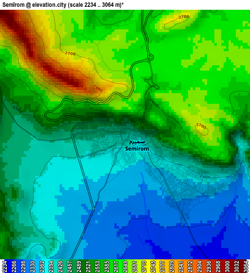
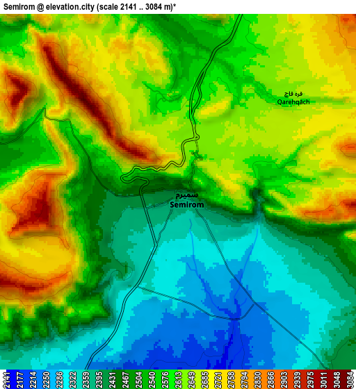
Below is the Elevation map of Semīrom, which displays elevation range with different colors. Scale of the first map is from 2234 to 3064 m (7329 to 10052 ft) with average elevation of 2509.2 meters (=8232 ft) [note 1]
These maps also provides idea of topography and contour of this city, they are displayed at different zoom levels. More info about maps, scale and edge coordinates you can find below images.
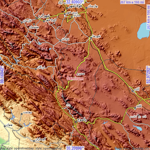
| \ | Map #1 | Map #2 | Topo.Map |
| Scale [m] | 2234..3064 m | 2141..3084 m | × |
| Scale [ft] | 7329..10052 ft | 7024..10118 ft | × |
| Average | 2509.2 m = 8232 ft | 2542.2 m = 8341 ft | × |
| Width | 8.34 km = 5.2 mi | 16.68 km = 10.4 mi | 266.9 km = 165.8 mi |
| Height | 8.34 km = 5.2 mi | 16.68 km = 10.4 mi | 266.9 km = 165.8 mi |
| ↑Max Latitude | 31.454165° | 31.491646° | 32.60903° |
| Latitude at center | 31.41667° | 31.41667° | 31.41667° |
| ↓Min Latitude | 31.37916° | 31.341634° | 30.20896° |
| ← Min Longitude | 51.522725° | 51.478779° | 50.16042° |
| Longitude center | 51.56667° | 51.56667° | 51.56667° |
| →Max Longitude | 51.610615° | 51.654561° | 52.97292° |
Nearby cities:
Cities around Semīrom sort by population:
• Yasuj elevation 1841 m
83.2 km,  178°
178°
• Ābādeh 2006 m
106.8 km,  105°
105°
• Borūjen 2230 m
66.5 km,  336°
336°
• Farrokh Shahr 2106 m
110 km,  329°
329°
• Zarrīn Shahr 1705 m
109.7 km,  350°
350°
• Ardal 1860 m
107.3 km,  307°
307°
• Mobārakeh 1674 m
103.6 km,  356°
356°
• Shalamzār 2016 m
99.7 km, 314°
• Shahreẕā 1823 m
71.7 km,  23°
23°
• Lordegān 1588 m
71 km,  278°
278°
• Sīsakht 2267 m
62.4 km,  189°
189°
• Dehāqān 2045 m
58.7 km,  7°
7°
Multilingual:
 En español:
Semīrom elevación 2425 m.
 En France:
Semīrom élévation 2425 m.
 Auf Deutsch:
Semīrom höhe über dem Meeresspiegel ist 2425 m.

Sources and notes:
- [note 1] Map square and city borders are not equal. Map elevation data is calculated only from area inside that square.
- [src 1] Elevation data from geonames database provided with same terms of usage.
- [src 2] The elevation map of Semīrom is generated using elevation data from NASA's 3 arcsec (90m) resolution SRTM data.
- [src 3] Base (background) map © OpenStreetMap contributors tiles are generated by Geofabrik and OpenTopoMap.
Copyright & License:
This Semīrom Elevation Map is licensed under CC BY-SA. You may reuse any part from this page, if you give a proper credit by linking to this URL:
 More info on terms of use page.