Batifa elevation
Batifa (Dahūk, Zakho District), Iraq elevation is 860 meters and Batifa elevation in feet is 2822 ft above sea level [src 1]. Batifa is a seat of a third-order administrative division (feature code) with elevation that is 567 meters (1860 ft) bigger than average city elevation in Iraq.
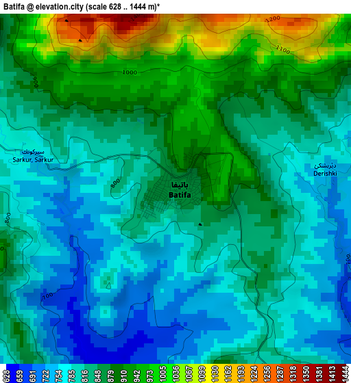
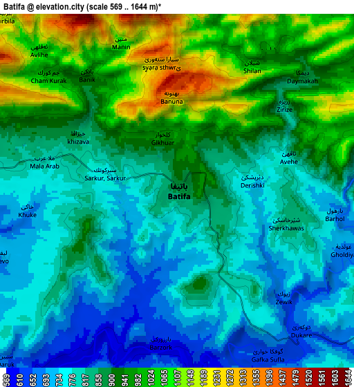
Below is the Elevation map of Batifa, which displays elevation range with different colors. Scale of the first map is from 628 to 1444 m (2060 to 4738 ft) with average elevation of 846.4 meters (=2777 ft) [note 1]
These maps also provides idea of topography and contour of this city, they are displayed at different zoom levels. More info about maps, scale and edge coordinates you can find below images.
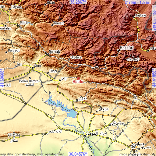
| \ | Map #1 | Map #2 | Topo.Map |
| Scale [m] | 628..1444 m | 569..1644 m | × |
| Scale [ft] | 2060..4738 ft | 1867..5394 ft | × |
| Average | 846.4 m = 2777 ft | 872.5 m = 2863 ft | × |
| Width | 7.79 km = 4.8 mi | 15.57 km = 9.7 mi | 249.2 km = 154.8 mi |
| Height | 7.79 km = 4.8 mi | 15.57 km = 9.7 mi | 249.2 km = 154.8 mi |
| ↑Max Latitude | 37.209547° | 37.244539° | 38.2867° |
| Latitude at center | 37.17454° | 37.17454° | 37.17454° |
| ↓Min Latitude | 37.139516° | 37.104476° | 36.04576° |
| ← Min Longitude | 42.968385° | 42.924439° | 41.60608° |
| Longitude center | 43.01233° | 43.01233° | 43.01233° |
| →Max Longitude | 43.056275° | 43.100221° | 44.41858° |
Nearby cities:
Cities around Batifa sort by population:
• Dihok elevation 567 m
34.3 km,  183°
183°
• Sīnah 669 m
40.8 km, 176°
• Zaxo 439 m
29.1 km,  264°
264°
• Ash Shaykhān 512 m
61.2 km,  150°
150°
• Al ‘Amādīyah 1187 m
43.1 km,  102°
102°
• Ibrāhīm al Khalīl 397 m
39.4 km, 264°
• Saymayl 465 m
38.1 km,  202°
202°
• Ain Nuni 1230 m
38.1 km,  81°
81°
• Zāwītah 848 m
32.1 km,  158°
158°
• Zaxu 437 m
29.5 km, 263°
• Bāmarnī 1280 m
23.7 km, 104°
• Derkar 651 m
17 km,  279°
279°
Multilingual:
 En español:
Batifa elevación 860 m.
 En France:
Batifa élévation 860 m.


Sources and notes:
- [note 1] Map square and city borders are not equal. Map elevation data is calculated only from area inside that square.
- [src 1] Elevation data from geonames database provided with same terms of usage.
- [src 2] The elevation map of Batifa is generated using elevation data from NASA's 3 arcsec (90m) resolution SRTM data.
- [src 3] Base (background) map © OpenStreetMap contributors tiles are generated by Geofabrik and OpenTopoMap.
Copyright & License:
This Batifa Elevation Map is licensed under CC BY-SA. You may reuse any part from this page, if you give a proper credit by linking to this URL:
 More info on terms of use page.