Mandalī elevation
Mandalī (Diyālá, Qada Balad Ruz), Iraq elevation is 129 meters and Mandalī elevation in feet is 423 ft above sea level [src 1]. Mandalī is a populated place (feature code) with elevation that is 164 meters (538 ft) smaller than average city elevation in Iraq.
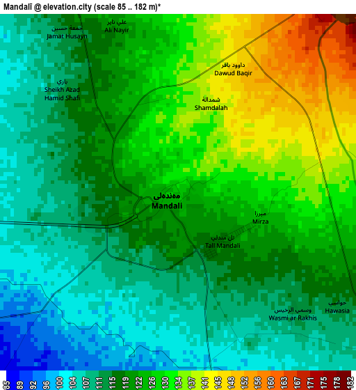
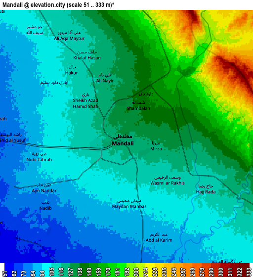
Below is the Elevation map of Mandalī, which displays elevation range with different colors. Scale of the first map is from 85 to 182 m (279 to 597 ft) with average elevation of 120.1 meters (=394 ft) [note 1]
These maps also provides idea of topography and contour of this city, they are displayed at different zoom levels. More info about maps, scale and edge coordinates you can find below images.
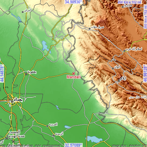
| \ | Map #1 | Map #2 | Topo.Map |
| Scale [m] | 85..182 m | 51..333 m | × |
| Scale [ft] | 279..597 ft | 167..1093 ft | × |
| Average | 120.1 m = 394 ft | 123 m = 404 ft | × |
| Width | 8.13 km = 5.1 mi | 16.25 km = 10.1 mi | 260 km = 161.6 mi |
| Height | 8.13 km = 5.1 mi | 16.25 km = 10.1 mi | 260 km = 161.6 mi |
| ↑Max Latitude | 33.784632° | 33.821149° | 34.90936° |
| Latitude at center | 33.7481° | 33.7481° | 33.7481° |
| ↓Min Latitude | 33.711552° | 33.674989° | 32.57089° |
| ← Min Longitude | 45.511085° | 45.467139° | 44.14878° |
| Longitude center | 45.55503° | 45.55503° | 45.55503° |
| →Max Longitude | 45.598975° | 45.642921° | 46.96128° |
Nearby cities:
Cities around Mandalī sort by population:
• Baghdad elevation 41 m
116.2 km,  247°
247°
• Baqubah 48 m
87.8 km,  270°
270°
• Khāliş 43 m
94.7 km, 274°
• Al Miqdādīyah 60 m
62.6 km,  294°
294°
• Al ‘Azīzīyah 28 m
103.8 km,  206°
206°
• Aş Şuwayrah 32 m
116.6 km,  218°
218°
• Aţ Ţārmīyah 41 m
107.5 km, 265°
• Kelar 216 m
100.2 km,  347°
347°
• Al Khāliş 49 m
96.3 km,  276°
276°
• Badrah 60 m
78.7 km,  153°
153°
• Khānaqīn 185 m
68.4 km, 347°
• Baladrūz 42 m
44.5 km,  262°
262°
Multilingual:
 En español:
Mandalī elevación 129 m.
 En France:
Mandalī élévation 129 m.


Sources and notes:
- [note 1] Map square and city borders are not equal. Map elevation data is calculated only from area inside that square.
- [src 1] Elevation data from geonames database provided with same terms of usage.
- [src 2] The elevation map of Mandalī is generated using elevation data from NASA's 3 arcsec (90m) resolution SRTM data.
- [src 3] Base (background) map © OpenStreetMap contributors tiles are generated by Geofabrik and OpenTopoMap.
Copyright & License:
This Mandalī Elevation Map is licensed under CC BY-SA. You may reuse any part from this page, if you give a proper credit by linking to this URL:
 More info on terms of use page.