Petaẖ Tiqwa elevation
Petaẖ Tiqwa (Central District), Israel elevation is 54 meters and Petaẖ Tiqwa elevation in feet is 177 ft above sea level [src 1]. Petaẖ Tiqwa is a populated place (feature code) with elevation that is 157 meters (515 ft) smaller than average city elevation in Israel.
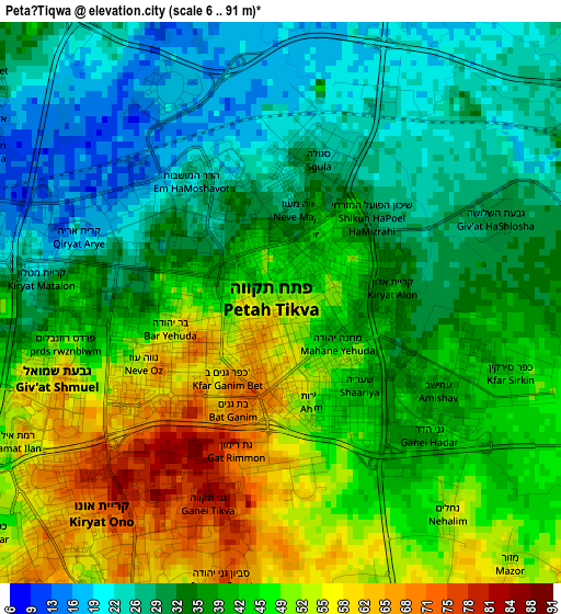
Below is the Elevation map of Petaẖ Tiqwa, which displays elevation range with different colors. Scale of the first map is from 6 to 91 m (20 to 299 ft) with average elevation of 39.8 meters (=131 ft) [note 1]
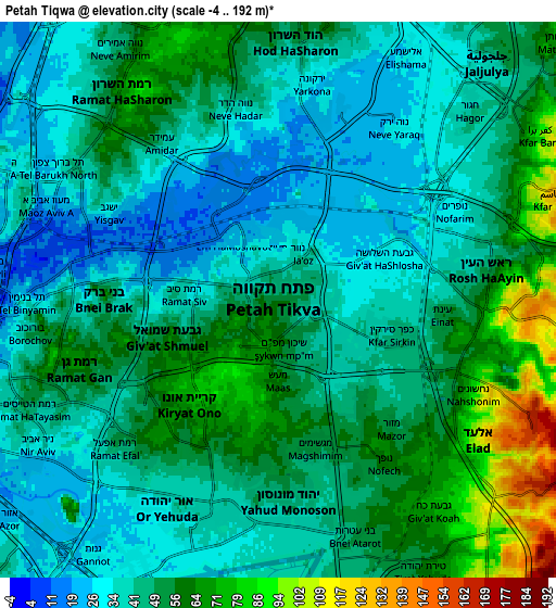
These maps also provides idea of topography and contour of this city, they are displayed at different zoom levels. More info about maps, scale and edge coordinates you can find below images.
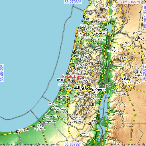
| \ | Map #1 | Map #2 | Topo.Map |
| Scale [m] | 6..91 m | -4..192 m | × |
| Scale [ft] | 20..299 ft | -13..630 ft | × |
| Average | 39.8 m = 131 ft | 47.3 m = 155 ft | × |
| Width | 8.28 km = 5.1 mi | 16.56 km = 10.3 mi | 264.9 km = 164.6 mi |
| Height | 8.28 km = 5.1 mi | 16.56 km = 10.3 mi | 264.9 km = 164.6 mi |
| ↑Max Latitude | 32.124295° | 32.161504° | 33.27069° |
| Latitude at center | 32.08707° | 32.08707° | 32.08707° |
| ↓Min Latitude | 32.04983° | 32.012575° | 30.88792° |
| ← Min Longitude | 34.843525° | 34.799579° | 33.48122° |
| Longitude center | 34.88747° | 34.88747° | 34.88747° |
| →Max Longitude | 34.931415° | 34.975361° | 36.29372° |
Nearby cities:
Cities around Petaẖ Tiqwa sort by population:
• Bnei Brak elevation 51 m
5.1 km,  262°
262°
• Ramat Gan 57 m
7.3 km,  265°
265°
• Givatayim 50 m
7.3 km, 256°
• Rosh Ha‘Ayin 62 m
6.6 km,  81°
81°
• Ramat HaSharon 68 m
8 km,  325°
325°
• Or Yehuda 33 m
7 km,  203°
203°
• Yehud-Monosson 36 m
6.6 km,  186°
186°
• Yehud 44 m
6 km,  176°
176°
• Giv'at Shmuel 53 m
3.8 km,  254°
254°
• Ganei Tikva 79 m
3.3 km, 203°
• Savyon 75 m
4.3 km, 192°
• Neẖalim 47 m
3.7 km,  143°
143°
Multilingual:
 En español:
Petaẖ Tiqwa elevación 54 m.
 En France:
Petaẖ Tiqwa élévation 54 m.
 Auf Deutsch:
Petaẖ Tiqwa höhe über dem Meeresspiegel ist 54 m.

Sources and notes:
- [note 1] Map square and city borders are not equal. Map elevation data is calculated only from area inside that square.
- [src 1] Elevation data from geonames database provided with same terms of usage.
- [src 2] The elevation map of Petaẖ Tiqwa is generated using elevation data from NASA's 3 arcsec (90m) resolution SRTM data.
- [src 3] Base (background) map © OpenStreetMap contributors tiles are generated by Geofabrik and OpenTopoMap.
Copyright & License:
This Petaẖ Tiqwa Elevation Map is licensed under CC BY-SA. You may reuse any part from this page, if you give a proper credit by linking to this URL:
 More info on terms of use page.