Greenhills elevation
Greenhills (Leinster, South Dublin), Ireland elevation is 23 meters and Greenhills elevation in feet is 75 ft above sea level [src 1]. Greenhills is a section of populated place (feature code) with elevation that is 28 meters (92 ft) smaller than average city elevation in Ireland.
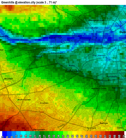
Below is the Elevation map of Greenhills, which displays elevation range with different colors. Scale of the first map is from 3 to 71 m (10 to 233 ft) with average elevation of 32.1 meters (=105 ft) [note 1]
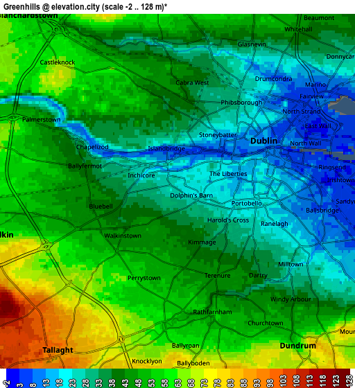
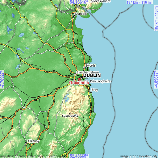
These maps also provides idea of topography and contour of this city, they are displayed at different zoom levels. More info about maps, scale and edge coordinates you can find below images.
| \ | Map #1 | Map #2 | Topo.Map |
| Scale [m] | 3..71 m | -2..128 m | × |
| Scale [ft] | 10..233 ft | -7..420 ft | × |
| Average | 32.1 m = 105 ft | 43.4 m = 142 ft | × |
| Width | 5.84 km = 3.6 mi | 11.67 km = 7.3 mi | 186.7 km = 116 mi |
| Height | 5.84 km = 3.6 mi | 11.67 km = 7.3 mi | 186.7 km = 116 mi |
| ↑Max Latitude | 53.360903° | 53.387121° | 54.16616° |
| Latitude at center | 53.33467° | 53.33467° | 53.33467° |
| ↓Min Latitude | 53.30842° | 53.282155° | 52.48665° |
| ← Min Longitude | -6.346965° | -6.390911° | -7.70927° |
| Longitude center | -6.30302° | -6.30302° | -6.30302° |
| →Max Longitude | -6.259075° | -6.215129° | -4.89677° |
Nearby cities:
Cities around Greenhills sort by population:
• Dublin elevation 17 m
3.6 km,  92°
92°
• Crumlin 49 m
1.6 km,  207°
207°
• Rathmines 27 m
3.1 km,  121°
121°
• Ballyfermot 17 m
3.6 km,  284°
284°
• Rathgar 39 m
2.9 km,  140°
140°
• Cherry Orchard 54 m
5 km,  271°
271°
• Terenure 44 m
3 km,  156°
156°
• Templeogue 57 m
4.4 km,  185°
185°
• Chapelizod 16 m
3.1 km,  300°
300°
• Cabra 36 m
3.6 km,  9°
9°
• Milltown 25 m
4.5 km, 122°
• Rialto 20 m
0.4 km,  65°
65°
Multilingual:
 En español:
Greenhills elevación 23 m.
 En France:
Greenhills élévation 23 m.
 Auf Deutsch:
Greenhills höhe über dem Meeresspiegel ist 23 m.

Sources and notes:
- [note 1] Map square and city borders are not equal. Map elevation data is calculated only from area inside that square.
- [src 1] Elevation data from geonames database provided with same terms of usage.
- [src 2] The elevation map of Greenhills is generated using elevation data from NASA's 3 arcsec (90m) resolution SRTM data.
- [src 3] Base (background) map © OpenStreetMap contributors tiles are generated by Geofabrik and OpenTopoMap.
Copyright & License:
This Greenhills Elevation Map is licensed under CC BY-SA. You may reuse any part from this page, if you give a proper credit by linking to this URL:
 More info on terms of use page.