Ballina elevation
Ballina (Connaught, Mayo County), Ireland elevation is 32 meters and Ballina elevation in feet is 105 ft above sea level [src 1]. Ballina is a populated place (feature code) with elevation that is 19 meters (62 ft) smaller than average city elevation in Ireland.
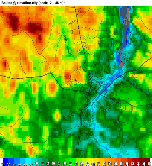
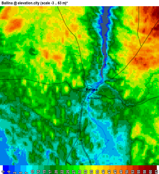
Below is the Elevation map of Ballina, which displays elevation range with different colors. Scale of the first map is from -2 to 48 m (-7 to 157 ft) with average elevation of 21.6 meters (=71 ft) [note 1]
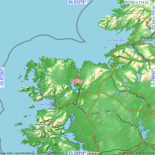
These maps also provides idea of topography and contour of this city, they are displayed at different zoom levels. More info about maps, scale and edge coordinates you can find below images.
| \ | Map #1 | Map #2 | Topo.Map |
| Scale [m] | -2..48 m | -3..63 m | × |
| Scale [ft] | -7..157 ft | -10..207 ft | × |
| Average | 21.6 m = 71 ft | 24.2 m = 79 ft | × |
| Width | 5.73 km = 3.6 mi | 11.46 km = 7.1 mi | 183.3 km = 113.9 mi |
| Height | 5.73 km = 3.6 mi | 11.46 km = 7.1 mi | 183.3 km = 113.9 mi |
| ↑Max Latitude | 54.14242° | 54.168154° | 54.93276° |
| Latitude at center | 54.11667° | 54.11667° | 54.11667° |
| ↓Min Latitude | 54.090904° | 54.065122° | 53.28419° |
| ← Min Longitude | -9.210615° | -9.254561° | -10.57292° |
| Longitude center | -9.16667° | -9.16667° | -9.16667° |
| →Max Longitude | -9.122725° | -9.078779° | -7.76042° |
Nearby cities:
Cities around Ballina sort by population:
• Castlebar elevation 40 m
30.9 km,  196°
196°
• Westport 19 m
42 km,  213°
213°
• Tobercurry 92 m
29.2 km,  104°
104°
• Strandhill 27 m
41.1 km,  65°
65°
• Ballymote 64 m
42.5 km,  94°
94°
• Swinford 62 m
23.3 km,  142°
142°
• Collooney 50 m
44 km,  80°
80°
• Ballisodare 23 m
44.1 km, 76°
• Foxford 12 m
15.5 km,  167°
167°
• Inishcrone 19 m
12.1 km,  23°
23°
• Kiltamagh 61 m
31.6 km,  159°
159°
• Crossmolina 20 m
10 km,  259°
259°
Multilingual:
 En español:
Ballina elevación 32 m.
 En France:
Ballina élévation 32 m.


Sources and notes:
- [note 1] Map square and city borders are not equal. Map elevation data is calculated only from area inside that square.
- [src 1] Elevation data from geonames database provided with same terms of usage.
- [src 2] The elevation map of Ballina is generated using elevation data from NASA's 3 arcsec (90m) resolution SRTM data.
- [src 3] Base (background) map © OpenStreetMap contributors tiles are generated by Geofabrik and OpenTopoMap.
Copyright & License:
This Ballina Elevation Map is licensed under CC BY-SA. You may reuse any part from this page, if you give a proper credit by linking to this URL:
 More info on terms of use page.