Carlow elevation
Carlow (Leinster, County Carlow), Ireland elevation is 55 meters and Carlow elevation in feet is 180 ft above sea level [src 1]. Carlow is a seat of a second-order administrative division (feature code) with elevation that is 4 meters (13 ft) bigger than average city elevation in Ireland.
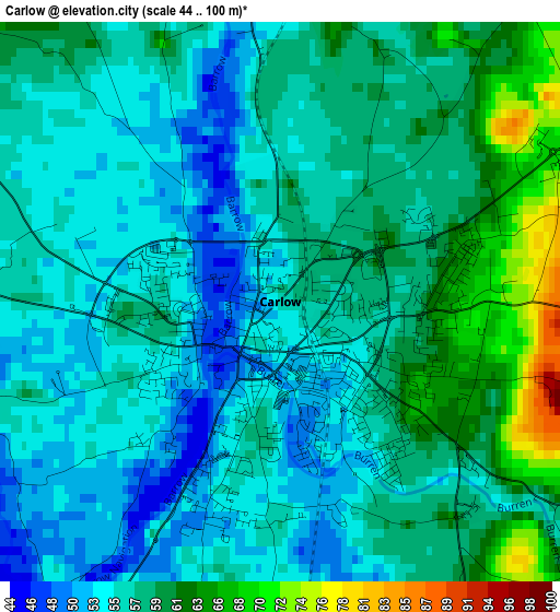
Below is the Elevation map of Carlow, which displays elevation range with different colors. Scale of the first map is from 44 to 100 m (144 to 328 ft) with average elevation of 57.1 meters (=187 ft) [note 1]
These maps also provides idea of topography and contour of this city, they are displayed at different zoom levels. More info about maps, scale and edge coordinates you can find below images.
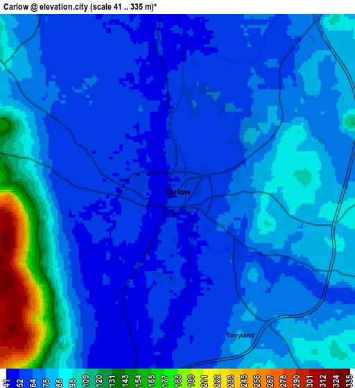
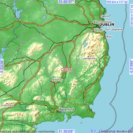
| \ | Map #1 | Map #2 | Topo.Map |
| Scale [m] | 44..100 m | 41..335 m | × |
| Scale [ft] | 144..328 ft | 135..1099 ft | × |
| Average | 57.1 m = 187 ft | 77.7 m = 255 ft | × |
| Width | 5.9 km = 3.7 mi | 11.81 km = 7.3 mi | 188.9 km = 117.4 mi |
| Height | 5.9 km = 3.7 mi | 11.81 km = 7.3 mi | 188.9 km = 117.4 mi |
| ↑Max Latitude | 52.867366° | 52.893886° | 53.68197° |
| Latitude at center | 52.84083° | 52.84083° | 52.84083° |
| ↓Min Latitude | 52.814278° | 52.787709° | 51.98308° |
| ← Min Longitude | -6.970055° | -7.014001° | -8.33236° |
| Longitude center | -6.92611° | -6.92611° | -6.92611° |
| →Max Longitude | -6.882165° | -6.838219° | -5.51986° |
Nearby cities:
Cities around Carlow sort by population:
• Athy elevation 62 m
17.1 km,  347°
347°
• Tullow 71 m
13.5 km,  109°
109°
• Bagenalstown 49 m
15.8 km,  188°
188°
• Baltinglass 128 m
18.1 km,  53°
53°
• Bunclody 35 m
27.6 km,  138°
138°
• Abbeyleix 111 m
29.2 km,  286°
286°
• Castlecomer 123 m
19.5 km,  258°
258°
• Castledermot 77 m
9.4 km,  36°
36°
• Moone 106 m
16.7 km,  26°
26°
• Stradbally 87 m
24.7 km,  321°
321°
• Ballyragget 76 m
27.8 km, 257°
• Ballylinan 81 m
13.9 km,  326°
326°
Multilingual:
 En español:
Carlow elevación 55 m.
 En France:
Carlow élévation 55 m.


Sources and notes:
- [note 1] Map square and city borders are not equal. Map elevation data is calculated only from area inside that square.
- [src 1] Elevation data from geonames database provided with same terms of usage.
- [src 2] The elevation map of Carlow is generated using elevation data from NASA's 3 arcsec (90m) resolution SRTM data.
- [src 3] Base (background) map © OpenStreetMap contributors tiles are generated by Geofabrik and OpenTopoMap.
Copyright & License:
This Carlow Elevation Map is licensed under CC BY-SA. You may reuse any part from this page, if you give a proper credit by linking to this URL:
 More info on terms of use page.