Carrick-on-Shannon elevation
Carrick-on-Shannon (Connaught, County Leitrim), Ireland elevation is 50 meters and Carrick-on-Shannon elevation in feet is 164 ft above sea level [src 1]. Carrick-on-Shannon is a seat of a second-order administrative division (feature code) with elevation that is 1 meters (3 ft) smaller than average city elevation in Ireland.
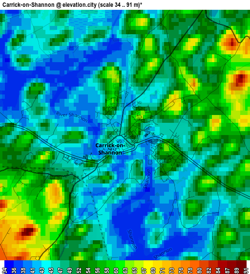
Below is the Elevation map of Carrick-on-Shannon, which displays elevation range with different colors. Scale of the first map is from 34 to 91 m (112 to 299 ft) with average elevation of 49.7 meters (=163 ft) [note 1]
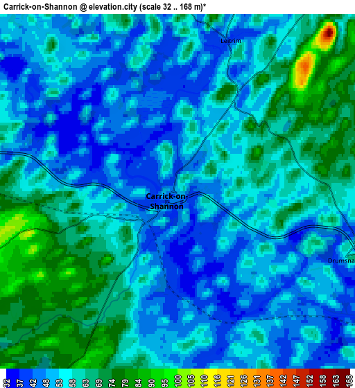
These maps also provides idea of topography and contour of this city, they are displayed at different zoom levels. More info about maps, scale and edge coordinates you can find below images.
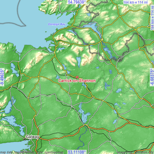
| \ | Map #1 | Map #2 | Topo.Map |
| Scale [m] | 34..91 m | 32..168 m | × |
| Scale [ft] | 112..299 ft | 105..551 ft | × |
| Average | 49.7 m = 163 ft | 56.5 m = 185 ft | × |
| Width | 5.75 km = 3.6 mi | 11.5 km = 7.1 mi | 184.1 km = 114.4 mi |
| Height | 5.75 km = 3.6 mi | 11.5 km = 7.1 mi | 184 km = 114.3 mi |
| ↑Max Latitude | 53.972795° | 53.998635° | 54.76638° |
| Latitude at center | 53.94694° | 53.94694° | 53.94694° |
| ↓Min Latitude | 53.921069° | 53.895181° | 53.11108° |
| ← Min Longitude | -8.133945° | -8.177891° | -9.49625° |
| Longitude center | -8.09° | -8.09° | -8.09° |
| →Max Longitude | -8.046055° | -8.002109° | -6.68375° |
Nearby cities:
Cities around Carrick-on-Shannon sort by population:
• Longford elevation 53 m
31.2 km,  142°
142°
• Roscommon 51 m
35.4 km,  189°
189°
• Boyle 73 m
13.9 km,  279°
279°
• Castlerea 63 m
33.5 km,  233°
233°
• Ballaghaderreen 83 m
32.7 km,  260°
260°
• Edgeworthstown 93 m
41.5 km,  131°
131°
• Ballymote 64 m
31.7 km,  298°
298°
• Lanesborough 53 m
31.9 km,  167°
167°
• Collooney 50 m
37.5 km,  314°
314°
• Ballisodare 23 m
40.1 km,  317°
317°
• Manorhamilton 57 m
40.4 km,  352°
352°
• Ballyconnell 53 m
38.1 km,  60°
60°
Multilingual:
 En español:
Carrick-on-Shannon elevación 50 m.
 En France:
Carrick-on-Shannon élévation 50 m.
 Auf Deutsch:
Carrick-on-Shannon höhe über dem Meeresspiegel ist 50 m.

Sources and notes:
- [note 1] Map square and city borders are not equal. Map elevation data is calculated only from area inside that square.
- [src 1] Elevation data from geonames database provided with same terms of usage.
- [src 2] The elevation map of Carrick-on-Shannon is generated using elevation data from NASA's 3 arcsec (90m) resolution SRTM data.
- [src 3] Base (background) map © OpenStreetMap contributors tiles are generated by Geofabrik and OpenTopoMap.
Copyright & License:
This Carrick-on-Shannon Elevation Map is licensed under CC BY-SA. You may reuse any part from this page, if you give a proper credit by linking to this URL:
 More info on terms of use page.