Cavan elevation
Cavan (Ulster, An Cabhán), Ireland elevation is 65 meters and Cavan elevation in feet is 213 ft above sea level [src 1]. Cavan is a seat of a second-order administrative division (feature code) with elevation that is 14 meters (46 ft) bigger than average city elevation in Ireland.
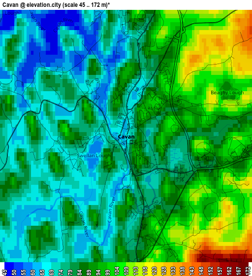
Below is the Elevation map of Cavan, which displays elevation range with different colors. Scale of the first map is from 45 to 172 m (148 to 564 ft) with average elevation of 85.3 meters (=280 ft) [note 1]
These maps also provides idea of topography and contour of this city, they are displayed at different zoom levels. More info about maps, scale and edge coordinates you can find below images.
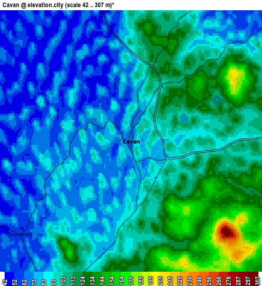
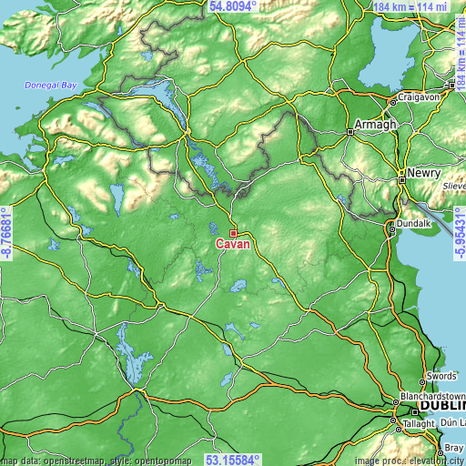
| \ | Map #1 | Map #2 | Topo.Map |
| Scale [m] | 45..172 m | 42..307 m | × |
| Scale [ft] | 148..564 ft | 138..1007 ft | × |
| Average | 85.3 m = 280 ft | 94.4 m = 310 ft | × |
| Width | 5.75 km = 3.6 mi | 11.49 km = 7.1 mi | 183.9 km = 114.3 mi |
| Height | 5.75 km = 3.6 mi | 11.49 km = 7.1 mi | 183.8 km = 114.2 mi |
| ↑Max Latitude | 54.016658° | 54.04247° | 54.8094° |
| Latitude at center | 53.99083° | 53.99083° | 53.99083° |
| ↓Min Latitude | 53.964986° | 53.939126° | 53.15584° |
| ← Min Longitude | -7.404505° | -7.448451° | -8.76681° |
| Longitude center | -7.36056° | -7.36056° | -7.36056° |
| →Max Longitude | -7.316615° | -7.272669° | -5.95431° |
Nearby cities:
Cities around Cavan sort by population:
• Ballyjamesduff elevation 110 m
17.4 km,  143°
143°
• Bailieborough 146 m
27.1 km,  107°
107°
• Virginia 92 m
25.6 km,  133°
133°
• Clones 72 m
23 km,  21°
21°
• Edgeworthstown 93 m
36.4 km,  207°
207°
• Cootehill 96 m
20.3 km,  63°
63°
• Oldcastle 102 m
28.1 km,  152°
152°
• Belturbet 48 m
13.5 km,  334°
334°
• Mullagh 106 m
33.3 km, 126°
• Ballyconnell 53 m
20.2 km,  313°
313°
• Castlepollard 87 m
34.9 km,  173°
173°
• Granard 134 m
25.1 km,  200°
200°
Multilingual:
 En español:
Cavan elevación 65 m.
 En France:
Cavan élévation 65 m.


Sources and notes:
- [note 1] Map square and city borders are not equal. Map elevation data is calculated only from area inside that square.
- [src 1] Elevation data from geonames database provided with same terms of usage.
- [src 2] The elevation map of Cavan is generated using elevation data from NASA's 3 arcsec (90m) resolution SRTM data.
- [src 3] Base (background) map © OpenStreetMap contributors tiles are generated by Geofabrik and OpenTopoMap.
Copyright & License:
This Cavan Elevation Map is licensed under CC BY-SA. You may reuse any part from this page, if you give a proper credit by linking to this URL:
 More info on terms of use page.