Ráth Luirc elevation
Ráth Luirc (Munster, County Cork), Ireland elevation is 109 meters and Ráth Luirc elevation in feet is 358 ft above sea level [src 1]. Ráth Luirc is a populated place (feature code) with elevation that is 58 meters (190 ft) bigger than average city elevation in Ireland.
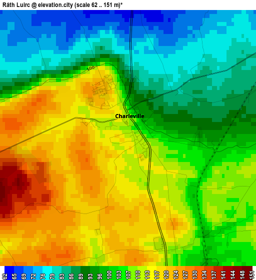
Below is the Elevation map of Ráth Luirc, which displays elevation range with different colors. Scale of the first map is from 62 to 151 m (203 to 495 ft) with average elevation of 103.1 meters (=338 ft) [note 1]
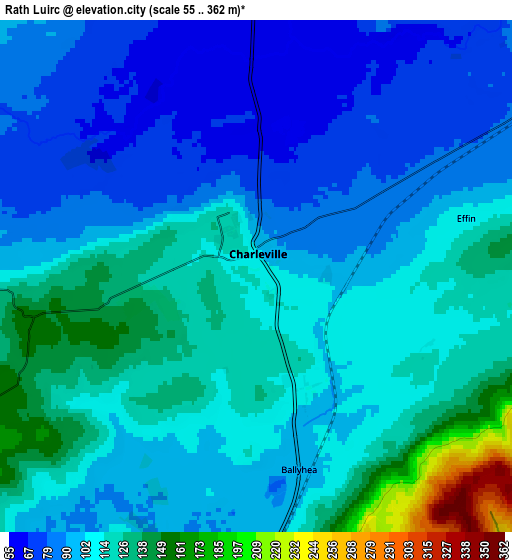
These maps also provides idea of topography and contour of this city, they are displayed at different zoom levels. More info about maps, scale and edge coordinates you can find below images.
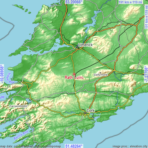
| \ | Map #1 | Map #2 | Topo.Map |
| Scale [m] | 62..151 m | 55..362 m | × |
| Scale [ft] | 203..495 ft | 180..1188 ft | × |
| Average | 103.1 m = 338 ft | 106.6 m = 350 ft | × |
| Width | 5.97 km = 3.7 mi | 11.94 km = 7.4 mi | 191 km = 118.7 mi |
| Height | 5.97 km = 3.7 mi | 11.94 km = 7.4 mi | 191 km = 118.7 mi |
| ↑Max Latitude | 52.376835° | 52.403654° | 53.20066° |
| Latitude at center | 52.35° | 52.35° | 52.35° |
| ↓Min Latitude | 52.323148° | 52.296281° | 51.48264° |
| ← Min Longitude | -8.727275° | -8.771221° | -10.08958° |
| Longitude center | -8.68333° | -8.68333° | -8.68333° |
| →Max Longitude | -8.639385° | -8.595439° | -7.27708° |
Nearby cities:
Cities around Ráth Luirc sort by population:
• Luimneach elevation 7 m
35.2 km,  6°
6°
• Mallow 58 m
24.3 km,  171°
171°
• Newcastle West 59 m
27.9 km,  293°
293°
• Fermoy 54 m
36.6 km,  130°
130°
• Mitchelstown 101 m
29.7 km,  108°
108°
• Kanturk 79 m
25.2 km,  215°
215°
• Kilmallock 87 m
9.1 km,  52°
52°
• Rathkeale 41 m
26 km,  318°
318°
• Caherconlish 60 m
30.7 km,  28°
28°
• Croom 21 m
19 km,  352°
352°
• Askeaton 7 m
34.1 km, 324°
• Adare 10 m
24.8 km,  342°
342°
Multilingual:
 En español:
Ráth Luirc elevación 109 m.
 En France:
Ráth Luirc élévation 109 m.
 Auf Deutsch:
Ráth Luirc höhe über dem Meeresspiegel ist 109 m.

Sources and notes:
- [note 1] Map square and city borders are not equal. Map elevation data is calculated only from area inside that square.
- [src 1] Elevation data from geonames database provided with same terms of usage.
- [src 2] The elevation map of Ráth Luirc is generated using elevation data from NASA's 3 arcsec (90m) resolution SRTM data.
- [src 3] Base (background) map © OpenStreetMap contributors tiles are generated by Geofabrik and OpenTopoMap.
Copyright & License:
This Ráth Luirc Elevation Map is licensed under CC BY-SA. You may reuse any part from this page, if you give a proper credit by linking to this URL:
 More info on terms of use page.