Enniscorthy elevation
Enniscorthy (Leinster, Loch Garman), Ireland elevation is 52 meters and Enniscorthy elevation in feet is 171 ft above sea level [src 1]. Enniscorthy is a populated place (feature code) with elevation that is 1 meters (3 ft) bigger than average city elevation in Ireland.
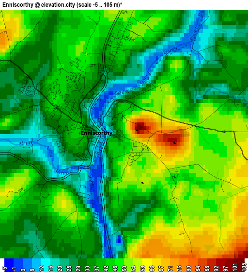
Below is the Elevation map of Enniscorthy, which displays elevation range with different colors. Scale of the first map is from -5 to 105 m (-16 to 344 ft) with average elevation of 39.9 meters (=131 ft) [note 1]
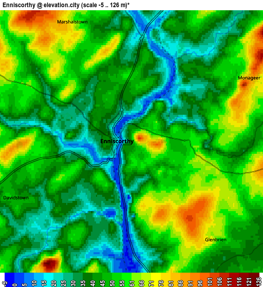
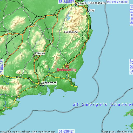
These maps also provides idea of topography and contour of this city, they are displayed at different zoom levels. More info about maps, scale and edge coordinates you can find below images.
| \ | Map #1 | Map #2 | Topo.Map |
| Scale [m] | -5..105 m | -5..126 m | × |
| Scale [ft] | -16..344 ft | -16..413 ft | × |
| Average | 39.9 m = 131 ft | 46.8 m = 154 ft | × |
| Width | 5.95 km = 3.7 mi | 11.9 km = 7.4 mi | 190.4 km = 118.3 mi |
| Height | 5.95 km = 3.7 mi | 11.9 km = 7.4 mi | 190.4 km = 118.3 mi |
| ↑Max Latitude | 52.527574° | 52.554301° | 53.34857° |
| Latitude at center | 52.50083° | 52.50083° | 52.50083° |
| ↓Min Latitude | 52.47407° | 52.447294° | 51.63642° |
| ← Min Longitude | -6.601725° | -6.645671° | -7.96403° |
| Longitude center | -6.55778° | -6.55778° | -6.55778° |
| →Max Longitude | -6.513835° | -6.469889° | -5.15153° |
Nearby cities:
Cities around Enniscorthy sort by population:
• Loch Garman elevation 5 m
19.7 km,  159°
159°
• New Ross 53 m
28.2 km,  245°
245°
• Gorey 46 m
26.4 km,  42°
42°
• Courtown 9 m
27.3 km,  54°
54°
• Bunclody 35 m
18.4 km,  339°
339°
• Castlebridge 17 m
14.7 km,  150°
150°
• Rosslare 4 m
27.6 km, 154°
• Graiguenamanagh 13 m
27.2 km,  279°
279°
• Ferns 58 m
10.5 km,  21°
21°
• Ballygerry 8 m
31.1 km, 154°
• Ballinroad 130 m
10.4 km,  79°
79°
• Carnew 101 m
23.4 km,  10°
10°
Multilingual:
 En español:
Enniscorthy elevación 52 m.
 En France:
Enniscorthy élévation 52 m.
 Auf Deutsch:
Enniscorthy höhe über dem Meeresspiegel ist 52 m.

Sources and notes:
- [note 1] Map square and city borders are not equal. Map elevation data is calculated only from area inside that square.
- [src 1] Elevation data from geonames database provided with same terms of usage.
- [src 2] The elevation map of Enniscorthy is generated using elevation data from NASA's 3 arcsec (90m) resolution SRTM data.
- [src 3] Base (background) map © OpenStreetMap contributors tiles are generated by Geofabrik and OpenTopoMap.
Copyright & License:
This Enniscorthy Elevation Map is licensed under CC BY-SA. You may reuse any part from this page, if you give a proper credit by linking to this URL:
 More info on terms of use page.