Gweedore elevation
Gweedore (Ulster, County Donegal), Ireland elevation is 60 meters and Gweedore elevation in feet is 197 ft above sea level [src 1]. Gweedore is a populated place (feature code) with elevation that is 9 meters (30 ft) bigger than average city elevation in Ireland.
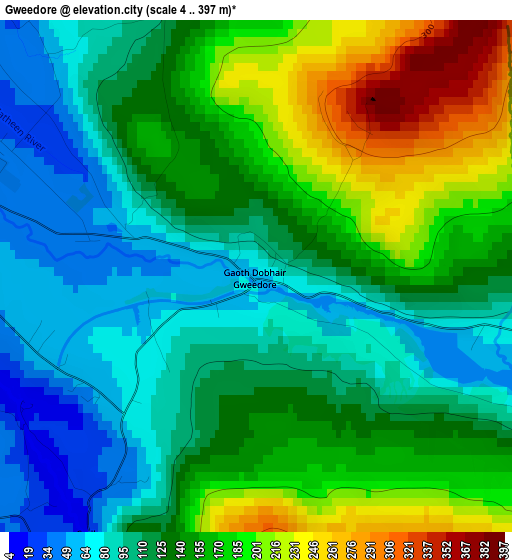
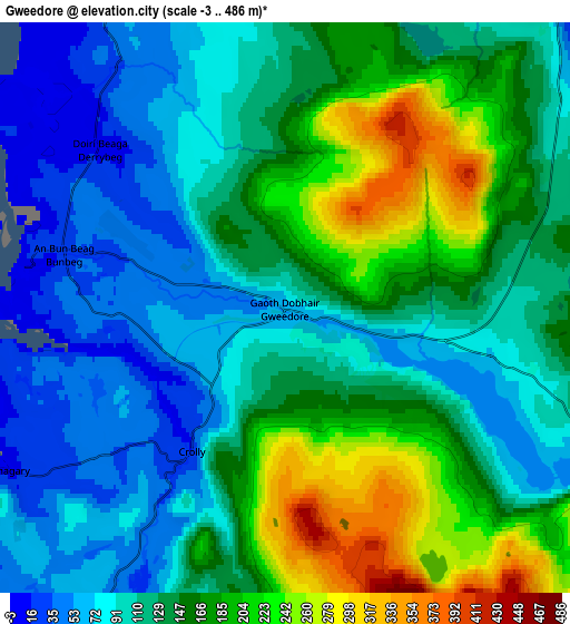
Below is the Elevation map of Gweedore, which displays elevation range with different colors. Scale of the first map is from 4 to 397 m (13 to 1302 ft) with average elevation of 137.2 meters (=450 ft) [note 1]
These maps also provides idea of topography and contour of this city, they are displayed at different zoom levels. More info about maps, scale and edge coordinates you can find below images.
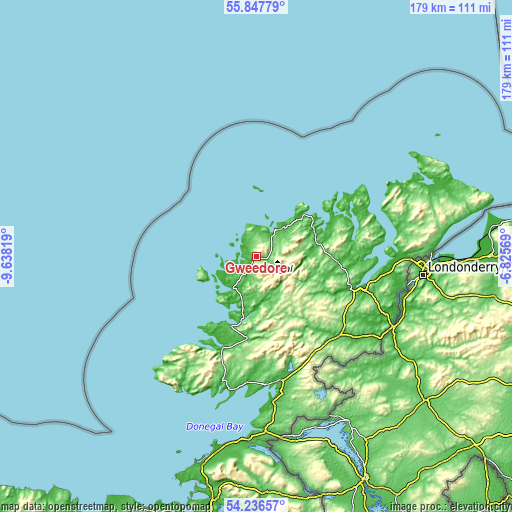
| \ | Map #1 | Map #2 | Topo.Map |
| Scale [m] | 4..397 m | -3..486 m | × |
| Scale [ft] | 13..1302 ft | -10..1594 ft | × |
| Average | 137.2 m = 450 ft | 136 m = 446 ft | × |
| Width | 5.6 km = 3.5 mi | 11.2 km = 7 mi | 179.2 km = 111.3 mi |
| Height | 5.6 km = 3.5 mi | 11.2 km = 7 mi | 179.1 km = 111.3 mi |
| ↑Max Latitude | 55.075446° | 55.100597° | 55.84779° |
| Latitude at center | 55.05028° | 55.05028° | 55.05028° |
| ↓Min Latitude | 55.025098° | 54.9999° | 54.23657° |
| ← Min Longitude | -8.275885° | -8.319831° | -9.63819° |
| Longitude center | -8.23194° | -8.23194° | -8.23194° |
| →Max Longitude | -8.187995° | -8.144049° | -6.82569° |
Nearby cities:
Cities around Gweedore sort by population:
• Letterkenny elevation 8 m
33.7 km,  109°
109°
• Ballybofey 21 m
40 km,  134°
134°
• Dunlewy 111 m
9.2 km, 113°
• Donegal 9 m
44.8 km,  170°
170°
• Derrybeg 15 m
5.2 km,  315°
315°
• Convoy 48 m
41.8 km,  120°
120°
• Killybegs 26 m
48.4 km,  196°
196°
• Ramelton 11 m
37.2 km,  92°
92°
• Dungloe 12 m
13.7 km,  216°
216°
• Raphoe 76 m
44.9 km, 115°
• Newtown Cunningham 5 m
45.8 km,  97°
97°
• Ballybofey-Stranorlar 19 m
40.2 km, 133°
Multilingual:
 En español:
Gweedore elevación 60 m.
 En France:
Gweedore élévation 60 m.


Sources and notes:
- [note 1] Map square and city borders are not equal. Map elevation data is calculated only from area inside that square.
- [src 1] Elevation data from geonames database provided with same terms of usage.
- [src 2] The elevation map of Gweedore is generated using elevation data from NASA's 3 arcsec (90m) resolution SRTM data.
- [src 3] Base (background) map © OpenStreetMap contributors tiles are generated by Geofabrik and OpenTopoMap.
Copyright & License:
This Gweedore Elevation Map is licensed under CC BY-SA. You may reuse any part from this page, if you give a proper credit by linking to this URL:
 More info on terms of use page.