Kells elevation
Kells (Leinster, An Mhí), Ireland elevation is 77 meters and Kells elevation in feet is 253 ft above sea level [src 1]. Kells is a populated place (feature code) with elevation that is 26 meters (85 ft) bigger than average city elevation in Ireland.
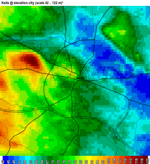
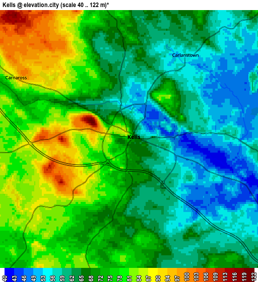
Below is the Elevation map of Kells, which displays elevation range with different colors. Scale of the first map is from 42 to 122 m (138 to 400 ft) with average elevation of 69.6 meters (=228 ft) [note 1]
These maps also provides idea of topography and contour of this city, they are displayed at different zoom levels. More info about maps, scale and edge coordinates you can find below images.
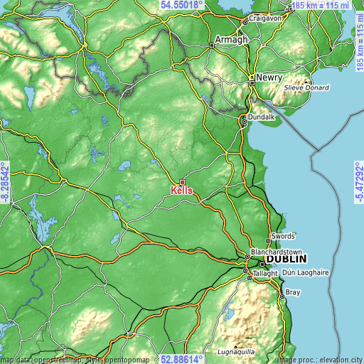
| \ | Map #1 | Map #2 | Topo.Map |
| Scale [m] | 42..122 m | 40..122 m | × |
| Scale [ft] | 138..400 ft | 131..400 ft | × |
| Average | 69.6 m = 228 ft | 69.7 m = 229 ft | × |
| Width | 5.78 km = 3.6 mi | 11.56 km = 7.2 mi | 185 km = 115 mi |
| Height | 5.78 km = 3.6 mi | 11.56 km = 7.2 mi | 185 km = 115 mi |
| ↑Max Latitude | 53.752382° | 53.778358° | 54.55018° |
| Latitude at center | 53.72639° | 53.72639° | 53.72639° |
| ↓Min Latitude | 53.700382° | 53.674358° | 52.88614° |
| ← Min Longitude | -6.923115° | -6.967061° | -8.28542° |
| Longitude center | -6.87917° | -6.87917° | -6.87917° |
| →Max Longitude | -6.835225° | -6.791279° | -5.47292° |
Nearby cities:
Cities around Kells sort by population:
• Navan elevation 35 m
15.4 km,  122°
122°
• Newtown Trim 53 m
20.3 km,  159°
159°
• Bailieborough 146 m
21.9 km,  344°
344°
• Athboy 66 m
11.7 km,  191°
191°
• Kingscourt 107 m
20.8 km,  13°
13°
• Virginia 92 m
17.6 km,  312°
312°
• Trim 56 m
19.9 km, 163°
• Ballivor 65 m
22.3 km, 194°
• Oldcastle 102 m
19.2 km,  283°
283°
• Slane 62 m
22.2 km,  94°
94°
• Mullagh 106 m
10.7 km,  333°
333°
• Kentstown 57 m
25.7 km, 115°
Multilingual:
 En español:
Kells elevación 77 m.
 En France:
Kells élévation 77 m.


Sources and notes:
- [note 1] Map square and city borders are not equal. Map elevation data is calculated only from area inside that square.
- [src 1] Elevation data from geonames database provided with same terms of usage.
- [src 2] The elevation map of Kells is generated using elevation data from NASA's 3 arcsec (90m) resolution SRTM data.
- [src 3] Base (background) map © OpenStreetMap contributors tiles are generated by Geofabrik and OpenTopoMap.
Copyright & License:
This Kells Elevation Map is licensed under CC BY-SA. You may reuse any part from this page, if you give a proper credit by linking to this URL:
 More info on terms of use page.