An Muileann gCearr elevation
An Muileann gCearr (Leinster, An Iarmhí), Ireland elevation is 113 meters and An Muileann gCearr elevation in feet is 371 ft above sea level [src 1]. An Muileann gCearr is a seat of a second-order administrative division (feature code) with elevation that is 62 meters (203 ft) bigger than average city elevation in Ireland.
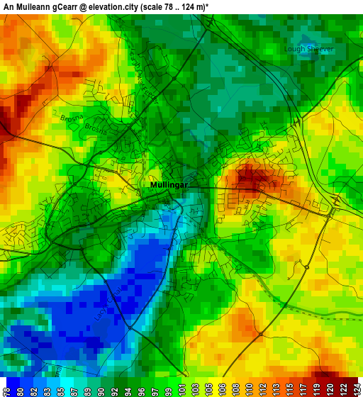
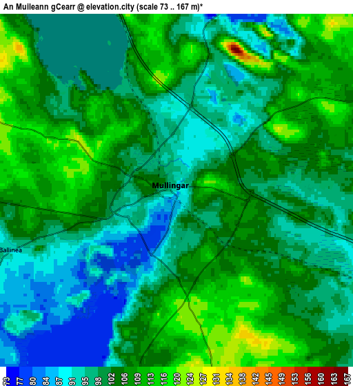
Below is the Elevation map of An Muileann gCearr, which displays elevation range with different colors. Scale of the first map is from 78 to 124 m (256 to 407 ft) with average elevation of 98.4 meters (=323 ft) [note 1]
These maps also provides idea of topography and contour of this city, they are displayed at different zoom levels. More info about maps, scale and edge coordinates you can find below images.
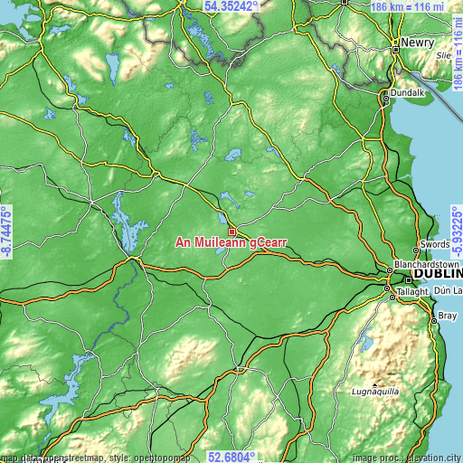
| \ | Map #1 | Map #2 | Topo.Map |
| Scale [m] | 78..124 m | 73..167 m | × |
| Scale [ft] | 256..407 ft | 240..548 ft | × |
| Average | 98.4 m = 323 ft | 101.6 m = 333 ft | × |
| Width | 5.81 km = 3.6 mi | 11.62 km = 7.2 mi | 185.9 km = 115.5 mi |
| Height | 5.81 km = 3.6 mi | 11.62 km = 7.2 mi | 185.9 km = 115.5 mi |
| ↑Max Latitude | 53.550776° | 53.576877° | 54.35242° |
| Latitude at center | 53.52466° | 53.52466° | 53.52466° |
| ↓Min Latitude | 53.498527° | 53.472379° | 52.6804° |
| ← Min Longitude | -7.382445° | -7.426391° | -8.74475° |
| Longitude center | -7.3385° | -7.3385° | -7.3385° |
| →Max Longitude | -7.294555° | -7.250609° | -5.93225° |
Nearby cities:
Cities around An Muileann gCearr sort by population:
• Edenderry elevation 97 m
28.2 km,  136°
136°
• Clara 55 m
27.3 km,  222°
222°
• Kinnegad 70 m
17.7 km,  117°
117°
• Edgeworthstown 93 m
26.8 km,  316°
316°
• Ballivor 65 m
25 km,  88°
88°
• Moate 59 m
25.1 km,  276°
276°
• Rochfortbridge 86 m
12.6 km,  167°
167°
• Longwood 66 m
28.7 km,  105°
105°
• Rathwire 86 m
13.6 km,  97°
97°
• Kilbeggan 67 m
20.4 km,  212°
212°
• Castlepollard 87 m
17.4 km,  8°
8°
• Daingean 79 m
25.6 km, 172°
Multilingual:
 En español:
An Muileann gCearr elevación 113 m.
 En France:
An Muileann gCearr élévation 113 m.
 Auf Deutsch:
An Muileann gCearr höhe über dem Meeresspiegel ist 113 m.
 На русском:
An Muileann gCearr высота над уровнем моря 113 м
Sources and notes:
- [note 1] Map square and city borders are not equal. Map elevation data is calculated only from area inside that square.
- [src 1] Elevation data from geonames database provided with same terms of usage.
- [src 2] The elevation map of An Muileann gCearr is generated using elevation data from NASA's 3 arcsec (90m) resolution SRTM data.
- [src 3] Base (background) map © OpenStreetMap contributors tiles are generated by Geofabrik and OpenTopoMap.
Copyright & License:
This An Muileann gCearr Elevation Map is licensed under CC BY-SA. You may reuse any part from this page, if you give a proper credit by linking to this URL:
 More info on terms of use page.