Ratoath elevation
Ratoath (Leinster, An Mhí), Ireland elevation is 92 meters and Ratoath elevation in feet is 302 ft above sea level [src 1]. Ratoath is a populated place (feature code) with elevation that is 41 meters (135 ft) bigger than average city elevation in Ireland.
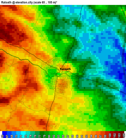
Below is the Elevation map of Ratoath, which displays elevation range with different colors. Scale of the first map is from 65 to 105 m (213 to 344 ft) with average elevation of 84.5 meters (=277 ft) [note 1]
These maps also provides idea of topography and contour of this city, they are displayed at different zoom levels. More info about maps, scale and edge coordinates you can find below images.
| \ | Map #1 | Map #2 | Topo.Map |
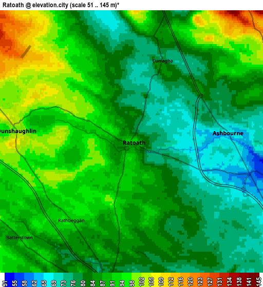
| Scale [m] | 65..105 m | 51..145 m | × |
| Scale [ft] | 213..344 ft | 167..476 ft | × |
| Average | 84.5 m = 277 ft | 86.6 m = 284 ft | × |
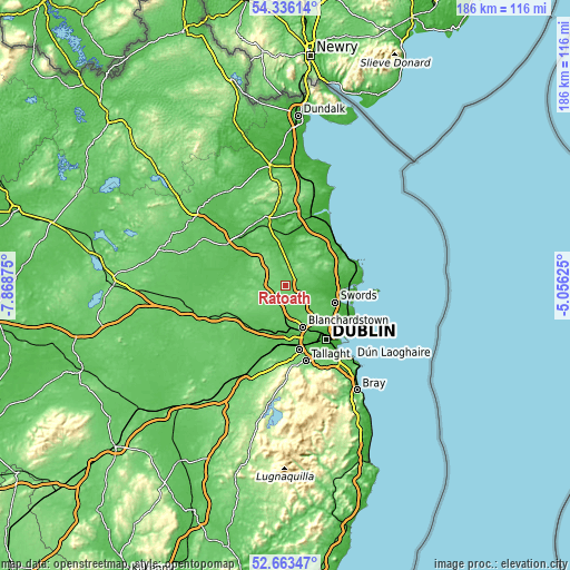
| Width | 5.81 km = 3.6 mi | 11.62 km = 7.2 mi | 186 km = 115.6 mi |
| Height | 5.81 km = 3.6 mi | 11.62 km = 7.2 mi | 186 km = 115.6 mi |
| ↑Max Latitude | 53.534187° | 53.560297° | 54.33614° |
| Latitude at center | 53.50806° | 53.50806° | 53.50806° |
| ↓Min Latitude | 53.481917° | 53.455758° | 52.66347° |
| ← Min Longitude | -6.506445° | -6.550391° | -7.86875° |
| Longitude center | -6.4625° | -6.4625° | -6.4625° |
| →Max Longitude | -6.418555° | -6.374609° | -5.05625° |
Nearby cities:
Cities around Ratoath sort by population:
• Blanchardstown elevation 49 m
14.5 km,  156°
156°
• Leixlip 48 m
16 km,  187°
187°
• Lucan 25 m
16.8 km,  176°
176°
• Maynooth 56 m
16.2 km,  212°
212°
• Ashbourne 68 m
4.3 km,  84°
84°
• Castleknock 61 m
16.2 km, 156°
• Dunboyne 69 m
9.9 km, 184°
• Hartstown 61 m
13 km,  169°
169°
• Confey 60 m
14.4 km, 187°
• Duleek 26 m
16.8 km,  9°
9°
• Dunshaughlin 100 m
5.1 km,  275°
275°
• Kentstown 57 m
13.9 km,  342°
342°
Multilingual:
 En español:
Ratoath elevación 92 m.
 En France:
Ratoath élévation 92 m.


Sources and notes:
- [note 1] Map square and city borders are not equal. Map elevation data is calculated only from area inside that square.
- [src 1] Elevation data from geonames database provided with same terms of usage.
- [src 2] The elevation map of Ratoath is generated using elevation data from NASA's 3 arcsec (90m) resolution SRTM data.
- [src 3] Base (background) map © OpenStreetMap contributors tiles are generated by Geofabrik and OpenTopoMap.
Copyright & License:
This Ratoath Elevation Map is licensed under CC BY-SA. You may reuse any part from this page, if you give a proper credit by linking to this URL:
 More info on terms of use page.