Sallins elevation
Sallins (Leinster, Kildare), Ireland elevation is 77 meters and Sallins elevation in feet is 253 ft above sea level [src 1]. Sallins is a populated place (feature code) with elevation that is 26 meters (85 ft) bigger than average city elevation in Ireland.
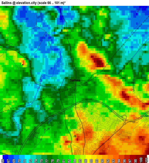
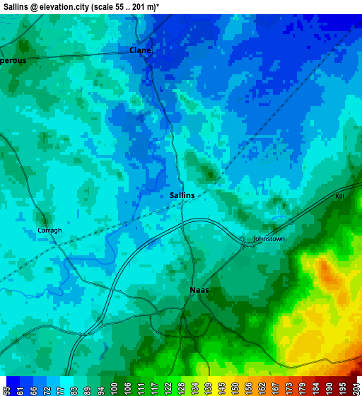
Below is the Elevation map of Sallins, which displays elevation range with different colors. Scale of the first map is from 66 to 101 m (217 to 331 ft) with average elevation of 80.1 meters (=263 ft) [note 1]
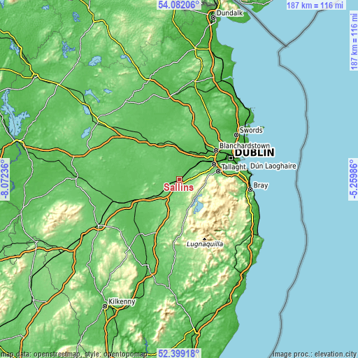
These maps also provides idea of topography and contour of this city, they are displayed at different zoom levels. More info about maps, scale and edge coordinates you can find below images.
| \ | Map #1 | Map #2 | Topo.Map |
| Scale [m] | 66..101 m | 55..201 m | × |
| Scale [ft] | 217..331 ft | 180..659 ft | × |
| Average | 80.1 m = 263 ft | 87.5 m = 287 ft | × |
| Width | 5.85 km = 3.6 mi | 11.69 km = 7.3 mi | 187.1 km = 116.3 mi |
| Height | 5.85 km = 3.6 mi | 11.69 km = 7.3 mi | 187.1 km = 116.3 mi |
| ↑Max Latitude | 53.275176° | 53.301446° | 54.08206° |
| Latitude at center | 53.24889° | 53.24889° | 53.24889° |
| ↓Min Latitude | 53.222588° | 53.196269° | 52.39918° |
| ← Min Longitude | -6.710055° | -6.754001° | -8.07236° |
| Longitude center | -6.66611° | -6.66611° | -6.66611° |
| →Max Longitude | -6.622165° | -6.578219° | -5.25986° |
Nearby cities:
Cities around Sallins sort by population:
• Naas elevation 93 m
3.7 km,  180°
180°
• Celbridge 54 m
13.1 km,  38°
38°
• Droichead Nua 92 m
11.4 km,  229°
229°
• Clane 68 m
5 km,  342°
342°
• Eadestown 175 m
7.8 km,  131°
131°
• Blessington 207 m
12.5 km, 134°
• Rathcoole 114 m
13.4 km,  73°
73°
• Kill 92 m
5 km,  86°
86°
• Newcastle 87 m
12.3 km,  61°
61°
• Prosperous 90 m
7.4 km,  308°
308°
• Athgarvan 98 m
13.2 km,  215°
215°
• Johnstown 90 m
3.1 km,  111°
111°
Multilingual:
 En español:
Sallins elevación 77 m.
 En France:
Sallins élévation 77 m.


Sources and notes:
- [note 1] Map square and city borders are not equal. Map elevation data is calculated only from area inside that square.
- [src 1] Elevation data from geonames database provided with same terms of usage.
- [src 2] The elevation map of Sallins is generated using elevation data from NASA's 3 arcsec (90m) resolution SRTM data.
- [src 3] Base (background) map © OpenStreetMap contributors tiles are generated by Geofabrik and OpenTopoMap.
Copyright & License:
This Sallins Elevation Map is licensed under CC BY-SA. You may reuse any part from this page, if you give a proper credit by linking to this URL:
 More info on terms of use page.