Les Cayes elevation
Les Cayes (Sud, Arrondissement des Cayes), Haiti elevation is 9 meters and Les Cayes elevation in feet is 30 ft above sea level [src 1]. Les Cayes is a seat of a first-order administrative division (feature code) with elevation that is 134 meters (440 ft) smaller than average city elevation in Haiti.
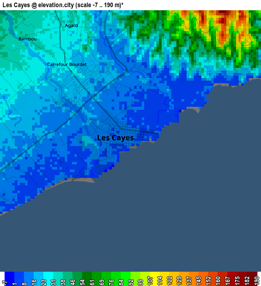
Below is the Elevation map of Les Cayes, which displays elevation range with different colors. Scale of the first map is from -7 to 190 m (-23 to 623 ft) with average elevation of 27.8 meters (=91 ft) [note 1]
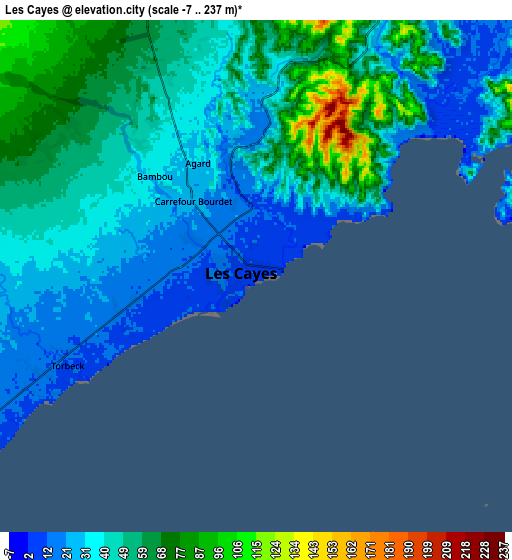
These maps also provides idea of topography and contour of this city, they are displayed at different zoom levels. More info about maps, scale and edge coordinates you can find below images.
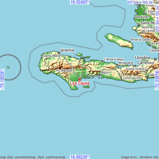
| \ | Map #1 | Map #2 | Topo.Map |
| Scale [m] | -7..190 m | -7..237 m | × |
| Scale [ft] | -23..623 ft | -23..778 ft | × |
| Average | 27.8 m = 91 ft | 45.4 m = 149 ft | × |
| Width | 9.28 km = 5.8 mi | 18.57 km = 11.5 mi | 297.1 km = 184.6 mi |
| Height | 9.28 km = 5.8 mi | 18.57 km = 11.5 mi | 297.1 km = 184.6 mi |
| ↑Max Latitude | 18.235053° | 18.276787° | 19.52403° |
| Latitude at center | 18.19331° | 18.19331° | 18.19331° |
| ↓Min Latitude | 18.151557° | 18.109793° | 16.85235° |
| ← Min Longitude | -73.789955° | -73.833901° | -75.15226° |
| Longitude center | -73.74601° | -73.74601° | -73.74601° |
| →Max Longitude | -73.702065° | -73.658119° | -72.33976° |
Nearby cities:
Cities around Les Cayes sort by population:
• Aquin elevation 11 m
38.4 km,  75°
75°
• Chardonnière 12 m
45.3 km,  281°
281°
• Port-à-Piment 12 m
37.6 km, 279°
• Corail 10 m
44.3 km,  340°
340°
• Petit Trou de Nippes 6 m
44.6 km,  34°
34°
• Koto 11 m
31.1 km,  272°
272°
• Torbeck 9 m
7.5 km,  243°
243°
• Chantal 56 m
15.2 km, 273°
• Baradères 11 m
34.1 km,  19°
19°
• Roche-à-Bateau 16 m
27.2 km, 267°
• Saint-Louis du Sud 12 m
22.5 km,  70°
70°
• Cavaillon 23 m
15.3 km,  39°
39°
Multilingual:
 En español:
Los Cayos elevación 9 m.
 En France:
Les Cayes élévation 9 m.


Sources and notes:
- [note 1] Map square and city borders are not equal. Map elevation data is calculated only from area inside that square.
- [src 1] Elevation data from geonames database provided with same terms of usage.
- [src 2] The elevation map of Les Cayes is generated using elevation data from NASA's 3 arcsec (90m) resolution SRTM data.
- [src 3] Base (background) map © OpenStreetMap contributors tiles are generated by Geofabrik and OpenTopoMap.
Copyright & License:
This Les Cayes Elevation Map is licensed under CC BY-SA. You may reuse any part from this page, if you give a proper credit by linking to this URL:
 More info on terms of use page.