Grangwav elevation
Grangwav (Ouest, Arrondissement de Léogâne), Haiti elevation is 23 meters and Grangwav elevation in feet is 75 ft above sea level [src 1]. Grangwav is a populated place (feature code) with elevation that is 120 meters (394 ft) smaller than average city elevation in Haiti.
Below is the Elevation map of Grangwav, which displays elevation range with different colors. Scale of the first map is from -2 to 787 m (-7 to 2582 ft) with average elevation of 170 meters (=558 ft) [note 1]
These maps also provides idea of topography and contour of this city, they are displayed at different zoom levels. More info about maps, scale and edge coordinates you can find below images.
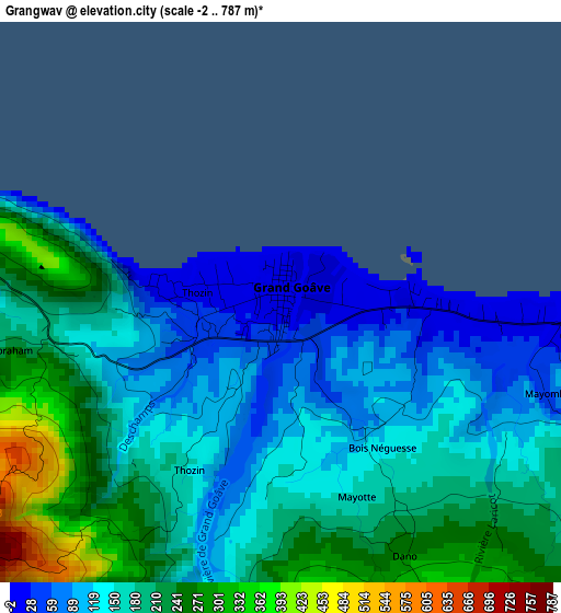
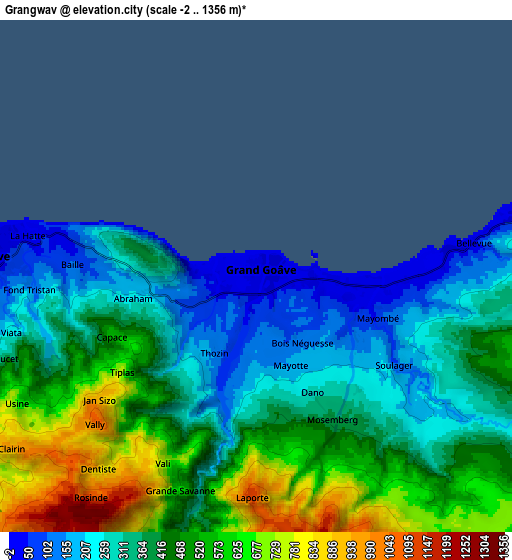
| \ | Map #1 | Map #2 | Topo.Map |
| Scale [m] | -2..787 m | -2..1356 m | × |
| Scale [ft] | -7..2582 ft | -7..4449 ft | × |
| Average | 170 m = 558 ft | 421 m = 1381 ft | × |
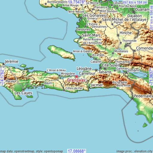
| Width | 9.27 km = 5.8 mi | 18.54 km = 11.5 mi | 296.7 km = 184.4 mi |
| Height | 9.27 km = 5.8 mi | 18.54 km = 11.5 mi | 296.7 km = 184.4 mi |
| ↑Max Latitude | 18.467587° | 18.509265° | 19.75478° |
| Latitude at center | 18.4259° | 18.4259° | 18.4259° |
| ↓Min Latitude | 18.384203° | 18.342495° | 17.08668° |
| ← Min Longitude | -72.813895° | -72.857841° | -74.1762° |
| Longitude center | -72.76995° | -72.76995° | -72.76995° |
| →Max Longitude | -72.726005° | -72.682059° | -71.3637° |
Nearby cities:
Cities around Grangwav sort by population:
• Port-au-Prince elevation 53 m
47.3 km,  73°
73°
• Carrefour 32 m
41.1 km, 71°
• Jacmel 33 m
32.7 km,  130°
130°
• Léogâne 18 m
17.2 km,  56°
56°
• Tigwav 16 m
10.1 km,  273°
273°
• Miragoâne 38 m
33.8 km, 273°
• Gressier 17 m
28.7 km, 63°
• Anse à Galets 22 m
46.6 km,  347°
347°
• Fond des Blancs 303 m
41.2 km,  246°
246°
• Kotdefè 9 m
36.1 km,  222°
222°
• Petite Rivière de Nippes 15 m
49.4 km,  276°
276°
• Cayes-Jacmel 15 m
45.1 km,  118°
118°
Multilingual:
 En español:
Grangwav elevación 23 m.
 En France:
Grand-Goâve élévation 23 m.


Sources and notes:
- [note 1] Map square and city borders are not equal. Map elevation data is calculated only from area inside that square.
- [src 1] Elevation data from geonames database provided with same terms of usage.
- [src 2] The elevation map of Grangwav is generated using elevation data from NASA's 3 arcsec (90m) resolution SRTM data.
- [src 3] Base (background) map © OpenStreetMap contributors tiles are generated by Geofabrik and OpenTopoMap.
Copyright & License:
This Grangwav Elevation Map is licensed under CC BY-SA. You may reuse any part from this page, if you give a proper credit by linking to this URL:
 More info on terms of use page.