Pétionville elevation
Pétionville (Ouest, Arrondissement de Port-au-Prince), Haiti elevation is 389 meters and Pétionville elevation in feet is 1276 ft above sea level [src 1]. Pétionville is a populated place (feature code) with elevation that is 246 meters (807 ft) bigger than average city elevation in Haiti.
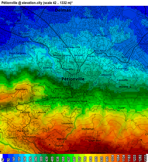
Below is the Elevation map of Pétionville, which displays elevation range with different colors. Scale of the first map is from 42 to 1332 m (138 to 4370 ft) with average elevation of 518.6 meters (=1701 ft) [note 1]
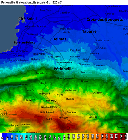
These maps also provides idea of topography and contour of this city, they are displayed at different zoom levels. More info about maps, scale and edge coordinates you can find below images.
| \ | Map #1 | Map #2 | Topo.Map |
| Scale [m] | 42..1332 m | -9..1920 m | × |
| Scale [ft] | 138..4370 ft | -30..6299 ft | × |
| Average | 518.6 m = 1701 ft | 571.6 m = 1875 ft | × |
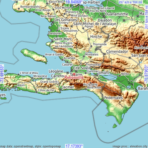
| Width | 9.27 km = 5.8 mi | 18.53 km = 11.5 mi | 296.5 km = 184.2 mi |
| Height | 9.27 km = 5.8 mi | 18.53 km = 11.5 mi | 296.5 km = 184.2 mi |
| ↑Max Latitude | 18.554166° | 18.595822° | 19.84068° |
| Latitude at center | 18.5125° | 18.5125° | 18.5125° |
| ↓Min Latitude | 18.470824° | 18.429137° | 17.17393° |
| ← Min Longitude | -72.329225° | -72.373171° | -73.69153° |
| Longitude center | -72.28528° | -72.28528° | -72.28528° |
| →Max Longitude | -72.241335° | -72.197389° | -70.87903° |
Nearby cities:
Cities around Pétionville sort by population:
• Port-au-Prince elevation 53 m
6.6 km,  301°
301°
• Carrefour 32 m
12.4 km,  284°
284°
• Delmas 73 129 m
4 km,  332°
332°
• Croix-des-Bouquets 69 m
9.5 km,  41°
41°
• Léogâne 18 m
36.7 km,  269°
269°
• Thomazeau 46 m
25.5 km,  52°
52°
• Kenscoff 1466 m
7.2 km,  178°
178°
• Gressier 17 m
25.7 km, 277°
• Fond Parisien 51 m
32.1 km,  91°
91°
• Cabaret 46 m
28.6 km, 330°
• Marigot 10 m
31.5 km,  187°
187°
• Cayes-Jacmel 15 m
33.4 km,  200°
200°
Multilingual:
 En español:
Pétionville elevación 389 m.
 En France:
Pétionville élévation 389 m.
 Auf Deutsch:
Pétionville höhe über dem Meeresspiegel ist 389 m.

Sources and notes:
- [note 1] Map square and city borders are not equal. Map elevation data is calculated only from area inside that square.
- [src 1] Elevation data from geonames database provided with same terms of usage.
- [src 2] The elevation map of Pétionville is generated using elevation data from NASA's 3 arcsec (90m) resolution SRTM data.
- [src 3] Base (background) map © OpenStreetMap contributors tiles are generated by Geofabrik and OpenTopoMap.
Copyright & License:
This Pétionville Elevation Map is licensed under CC BY-SA. You may reuse any part from this page, if you give a proper credit by linking to this URL:
 More info on terms of use page.