Drenova elevation
Drenova (Primorsko-Goranska), Croatia elevation is 278 meters and Drenova elevation in feet is 912 ft above sea level [src 1]. Drenova is a populated place (feature code) with elevation that is 124 meters (407 ft) bigger than average city elevation in Croatia.
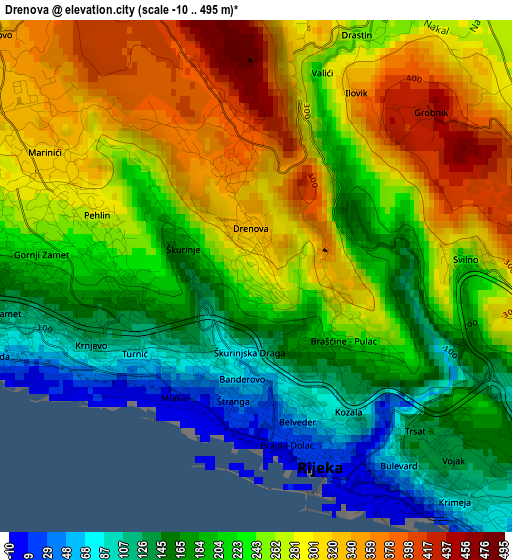
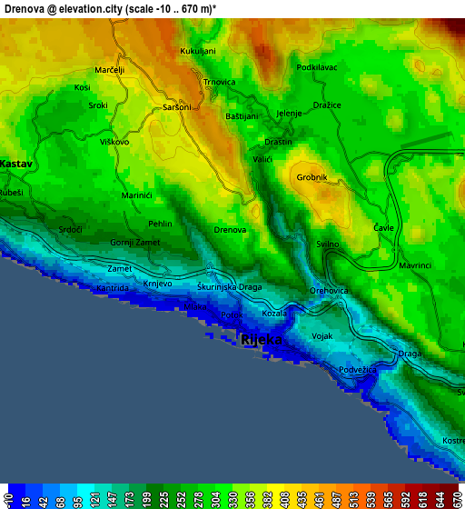
Below is the Elevation map of Drenova, which displays elevation range with different colors. Scale of the first map is from -10 to 495 m (-33 to 1624 ft) with average elevation of 238.4 meters (=782 ft) [note 1]
These maps also provides idea of topography and contour of this city, they are displayed at different zoom levels. More info about maps, scale and edge coordinates you can find below images.
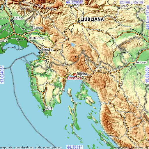
| \ | Map #1 | Map #2 | Topo.Map |
| Scale [m] | -10..495 m | -10..670 m | × |
| Scale [ft] | -33..1624 ft | -33..2198 ft | × |
| Average | 238.4 m = 782 ft | 287.7 m = 944 ft | × |
| Width | 6.87 km = 4.3 mi | 13.74 km = 8.5 mi | 219.8 km = 136.6 mi |
| Height | 6.87 km = 4.3 mi | 13.74 km = 8.5 mi | 219.8 km = 136.6 mi |
| ↑Max Latitude | 45.380875° | 45.411734° | 46.32965° |
| Latitude at center | 45.35° | 45.35° | 45.35° |
| ↓Min Latitude | 45.319108° | 45.288199° | 44.3531° |
| ← Min Longitude | 14.386335° | 14.342389° | 13.02403° |
| Longitude center | 14.43028° | 14.43028° | 14.43028° |
| →Max Longitude | 14.474225° | 14.518171° | 15.83653° |
Nearby cities:
Cities around Drenova sort by population:
• Rijeka elevation 12 m
2.8 km,  159°
159°
• Marinići 319 m
3.3 km,  300°
300°
• Viškovo 333 m
4.6 km,  308°
308°
• Marčelji 398 m
6 km,  328°
328°
• Dražice 297 m
5.5 km,  34°
34°
• Kastav 362 m
7 km,  293°
293°
• Rubeši 290 m
6.7 km, 286°
• Buzdohanj 307 m
4.6 km,  96°
96°
• Podhum 288 m
5.6 km,  42°
42°
• Cernik 277 m
5.7 km, 97°
• Čavle 348 m
4.2 km,  87°
87°
• Jelenje 315 m
4.3 km,  22°
22°
Multilingual:
 En español:
Drenova elevación 278 m.
 En France:
Drenova élévation 278 m.


Sources and notes:
- [note 1] Map square and city borders are not equal. Map elevation data is calculated only from area inside that square.
- [src 1] Elevation data from geonames database provided with same terms of usage.
- [src 2] The elevation map of Drenova is generated using elevation data from NASA's 3 arcsec (90m) resolution SRTM data.
- [src 3] Base (background) map © OpenStreetMap contributors tiles are generated by Geofabrik and OpenTopoMap.
Copyright & License:
This Drenova Elevation Map is licensed under CC BY-SA. You may reuse any part from this page, if you give a proper credit by linking to this URL:
 More info on terms of use page.