Jalžabet elevation
Jalžabet (Varaždinska), Croatia elevation is 170 meters and Jalžabet elevation in feet is 558 ft above sea level [src 1]. Jalžabet is a seat of a second-order administrative division (feature code) with elevation that is 16 meters (52 ft) bigger than average city elevation in Croatia.
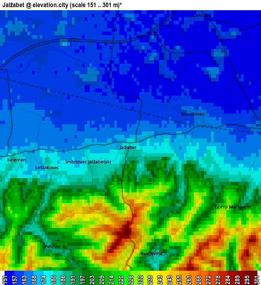
Below is the Elevation map of Jalžabet, which displays elevation range with different colors. Scale of the first map is from 151 to 301 m (495 to 988 ft) with average elevation of 184.9 meters (=607 ft) [note 1]
These maps also provides idea of topography and contour of this city, they are displayed at different zoom levels. More info about maps, scale and edge coordinates you can find below images.
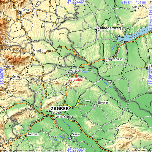
| \ | Map #1 | Topo.Map |
| Scale [m] | 151..301 m | × |
| Scale [ft] | 495..988 ft | × |
| Average | 184.9 m = 607 ft | × |
| Width | 6.76 km = 4.2 mi | 216.2 km = 134.3 mi |
| Height | 6.76 km = 4.2 mi | 216.2 km = 134.3 mi |
| ↑Max Latitude | 46.291204° | 47.22446° |
| Latitude at center | 46.26083° | 46.26083° |
| ↓Min Latitude | 46.230439° | 45.27996° |
| ← Min Longitude | 16.431055° | 15.06875° |
| Longitude center | 16.475° | 16.475° |
| →Max Longitude | 16.518945° | 17.88125° |
Nearby cities:
Cities around Jalžabet sort by population:
• Varaždin elevation 173 m
11.6 km,  294°
294°
• Ludbreg 157 m
10.8 km,  95°
95°
• Ivanovec 157 m
12 km,  0°
0°
• Orehovica 159 m
8.3 km,  17°
17°
• Gornji Kneginec 190 m
7.7 km,  261°
261°
• Kuršanec 165 m
9.6 km,  323°
323°
• Kućan Marof 165 m
8.5 km, 291°
• Sveti Ilija 190 m
11.6 km, 262°
• Sveti Ðurđ 148 m
10.3 km,  75°
75°
• Varaždinske Toplice 189 m
7.2 km,  216°
216°
• Trnovec Bartolovečki 164 m
7 km,  302°
302°
• Martijanec 153 m
5 km, 83°
Multilingual:
 En español:
Jalžabet elevación 170 m.
 En France:
Jalžabet élévation 170 m.
 Auf Deutsch:
Jalžabet höhe über dem Meeresspiegel ist 170 m.

Sources and notes:
- [note 1] Map square and city borders are not equal. Map elevation data is calculated only from area inside that square.
- [src 1] Elevation data from geonames database provided with same terms of usage.
- [src 2] The elevation map of Jalžabet is generated using elevation data from NASA's 3 arcsec (90m) resolution SRTM data.
- [src 3] Base (background) map © OpenStreetMap contributors tiles are generated by Geofabrik and OpenTopoMap.
Copyright & License:
This Jalžabet Elevation Map is licensed under CC BY-SA. You may reuse any part from this page, if you give a proper credit by linking to this URL:
 More info on terms of use page.