Mali Lošinj elevation
Mali Lošinj (Primorsko-Goranska), Croatia elevation is 14 meters and Mali Lošinj elevation in feet is 46 ft above sea level [src 1]. Mali Lošinj is a seat of a second-order administrative division (feature code) with elevation that is 140 meters (459 ft) smaller than average city elevation in Croatia.
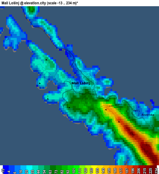
Below is the Elevation map of Mali Lošinj, which displays elevation range with different colors. Scale of the first map is from -13 to 234 m (-43 to 768 ft) with average elevation of 54.1 meters (=177 ft) [note 1]
These maps also provides idea of topography and contour of this city, they are displayed at different zoom levels. More info about maps, scale and edge coordinates you can find below images.
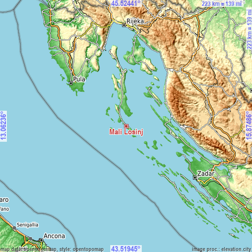
| \ | Map #1 | Topo.Map |
| Scale [m] | -13..234 m | × |
| Scale [ft] | -43..768 ft | × |
| Average | 54.1 m = 177 ft | × |
| Width | 6.97 km = 4.3 mi | 222.9 km = 138.5 mi |
| Height | 6.97 km = 4.3 mi | 222.9 km = 138.5 mi |
| ↑Max Latitude | 44.561879° | 45.52441° |
| Latitude at center | 44.53056° | 44.53056° |
| ↓Min Latitude | 44.499224° | 43.51945° |
| ← Min Longitude | 14.424665° | 13.06236° |
| Longitude center | 14.46861° | 14.46861° |
| →Max Longitude | 14.512555° | 15.87486° |
Nearby cities:
Cities around Mali Lošinj sort by population:
• Pag elevation 18 m
47.7 km,  101°
101°
• Cres 11 m
48.1 km,  354°
354°
• Novalja 17 m
33.3 km,  84°
84°
• Banjol 13 m
34.9 km,  45°
45°
• Stari Grad 18 m
48.4 km, 103°
• Lopar 21 m
39.4 km,  31°
31°
• Kampor 54 m
33.6 km,  36°
36°
• Supetarska Draga 0 m
35.9 km, 34°
• Karlobag 30 m
48 km,  90°
90°
• Ližnjan 58 m
52.3 km,  309°
309°
• Rab 9 m
34.2 km, 42°
• Kolan 113 m
39.3 km, 95°
Multilingual:
 En español:
Mali Lošinj elevación 14 m.
 En France:
Mali Lošinj élévation 14 m.
 Auf Deutsch:
Mali Lošinj höhe über dem Meeresspiegel ist 14 m.
 На русском:
Мали Лошинь, Мали-Лошинь высота над уровнем моря 14 м
Sources and notes:
- [note 1] Map square and city borders are not equal. Map elevation data is calculated only from area inside that square.
- [src 1] Elevation data from geonames database provided with same terms of usage.
- [src 2] The elevation map of Mali Lošinj is generated using elevation data from NASA's 3 arcsec (90m) resolution SRTM data.
- [src 3] Base (background) map © OpenStreetMap contributors tiles are generated by Geofabrik and OpenTopoMap.
Copyright & License:
This Mali Lošinj Elevation Map is licensed under CC BY-SA. You may reuse any part from this page, if you give a proper credit by linking to this URL:
 More info on terms of use page.