Podstrana elevation
Podstrana (Split-Dalmatia), Croatia elevation is 20 meters and Podstrana elevation in feet is 66 ft above sea level [src 1]. Podstrana is a populated place (feature code) with elevation that is 134 meters (440 ft) smaller than average city elevation in Croatia.
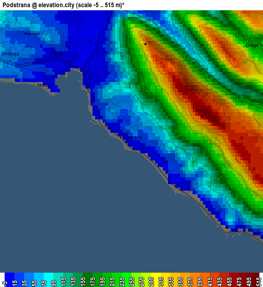
Below is the Elevation map of Podstrana, which displays elevation range with different colors. Scale of the first map is from -5 to 515 m (-16 to 1690 ft) with average elevation of 167.3 meters (=549 ft) [note 1]
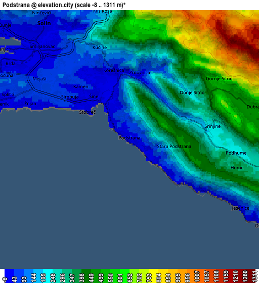
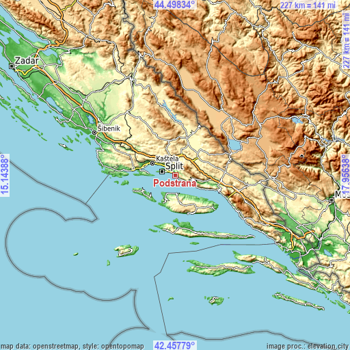
These maps also provides idea of topography and contour of this city, they are displayed at different zoom levels. More info about maps, scale and edge coordinates you can find below images.
| \ | Map #1 | Map #2 | Topo.Map |
| Scale [m] | -5..515 m | -8..1311 m | × |
| Scale [ft] | -16..1690 ft | -26..4301 ft | × |
| Average | 167.3 m = 549 ft | 321.9 m = 1056 ft | × |
| Width | 7.09 km = 4.4 mi | 14.18 km = 8.8 mi | 226.9 km = 141 mi |
| Height | 7.09 km = 4.4 mi | 14.18 km = 8.8 mi | 226.9 km = 141 mi |
| ↑Max Latitude | 43.518555° | 43.550414° | 44.49834° |
| Latitude at center | 43.48668° | 43.48668° | 43.48668° |
| ↓Min Latitude | 43.454788° | 43.422879° | 42.45779° |
| ← Min Longitude | 16.506185° | 16.462239° | 15.14388° |
| Longitude center | 16.55013° | 16.55013° | 16.55013° |
| →Max Longitude | 16.594075° | 16.638021° | 17.95638° |
Nearby cities:
Cities around Podstrana sort by population:
• Split elevation 12 m
9.3 km,  285°
285°
• Solin 15 m
7.8 km,  323°
323°
• Žrnovnica 48 m
3.9 km,  10°
10°
• Stobreč 18 m
2.9 km,  308°
308°
• Klis 271 m
8.5 km,  342°
342°
• Jesenice 42 m
5 km,  123°
123°
• Kamen 63 m
4.2 km, 316°
• Mravince 139 m
5.7 km, 336°
• Duće 71 m
10.7 km, 117°
• Srinjine 350 m
4 km,  95°
95°
• Vranjic 1 m
8.5 km, 307°
• Dugi Rat 9 m
8.5 km, 121°
Multilingual:
 En español:
Podstrana elevación 20 m.
 En France:
Podstrana élévation 20 m.
 Auf Deutsch:
Podstrana höhe über dem Meeresspiegel ist 20 m.

Sources and notes:
- [note 1] Map square and city borders are not equal. Map elevation data is calculated only from area inside that square.
- [src 1] Elevation data from geonames database provided with same terms of usage.
- [src 2] The elevation map of Podstrana is generated using elevation data from NASA's 3 arcsec (90m) resolution SRTM data.
- [src 3] Base (background) map © OpenStreetMap contributors tiles are generated by Geofabrik and OpenTopoMap.
Copyright & License:
This Podstrana Elevation Map is licensed under CC BY-SA. You may reuse any part from this page, if you give a proper credit by linking to this URL:
 More info on terms of use page.