Podvinje elevation
Podvinje (Slavonski Brod-Posavina, Grad Slavonski Brod), Croatia elevation is 114 meters and Podvinje elevation in feet is 374 ft above sea level [src 1]. Podvinje is a populated place (feature code) with elevation that is 40 meters (131 ft) smaller than average city elevation in Croatia.
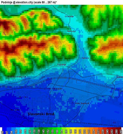
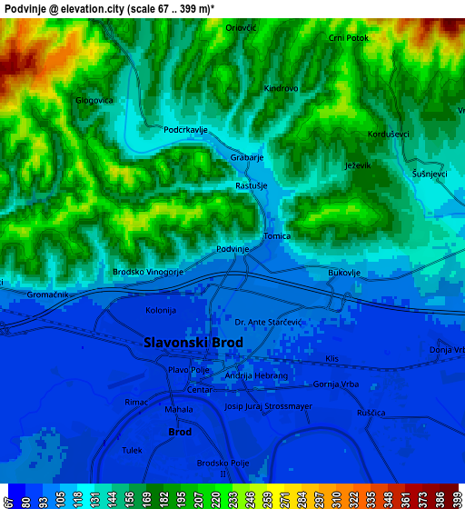
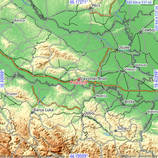
Below is the Elevation map of Podvinje, which displays elevation range with different colors. Scale of the first map is from 80 to 267 m (262 to 876 ft) with average elevation of 131.7 meters (=432 ft) [note 1]
These maps also provides idea of topography and contour of this city, they are displayed at different zoom levels. More info about maps, scale and edge coordinates you can find below images.
| \ | Map #1 | Map #2 | Topo.Map |
| Scale [m] | 80..267 m | 67..399 m | × |
| Scale [ft] | 262..876 ft | 220..1309 ft | × |
| Average | 131.7 m = 432 ft | 139.8 m = 459 ft | × |
| Width | 6.89 km = 4.3 mi | 13.77 km = 8.6 mi | 220.4 km = 136.9 mi |
| Height | 6.89 km = 4.3 mi | 13.77 km = 8.6 mi | 220.4 km = 136.9 mi |
| ↑Max Latitude | 45.221242° | 45.252188° | 46.17271° |
| Latitude at center | 45.19028° | 45.19028° | 45.19028° |
| ↓Min Latitude | 45.159301° | 45.128305° | 44.19059° |
| ← Min Longitude | 17.982995° | 17.939049° | 16.62069° |
| Longitude center | 18.02694° | 18.02694° | 18.02694° |
| →Max Longitude | 18.070885° | 18.114831° | 19.43319° |
Nearby cities:
Cities around Podvinje sort by population:
• Slavonski Brod elevation 89 m
3.5 km,  194°
194°
• Sibinj 124 m
9.3 km,  270°
270°
• Brodski Varoš 111 m
3.9 km,  254°
254°
• Bukovlje 112 m
3.4 km,  99°
99°
• Korenica 171 m
11.5 km,  70°
70°
• Slobodnica 88 m
8 km, 247°
• Ruščica 89 m
6.4 km,  139°
139°
• Garčin 92 m
12.3 km,  93°
93°
• Oprisavci 85 m
16.5 km,  105°
105°
• Klakar 87 m
13.1 km, 140°
• Gornja Vrba 92 m
4.9 km, 142°
• Podcrkavlje 131 m
4 km,  340°
340°
Multilingual:
 En español:
Podvinje elevación 114 m.
 En France:
Podvinje élévation 114 m.
 Auf Deutsch:
Podvinje höhe über dem Meeresspiegel ist 114 m.

Sources and notes:
- [note 1] Map square and city borders are not equal. Map elevation data is calculated only from area inside that square.
- [src 1] Elevation data from geonames database provided with same terms of usage.
- [src 2] The elevation map of Podvinje is generated using elevation data from NASA's 3 arcsec (90m) resolution SRTM data.
- [src 3] Base (background) map © OpenStreetMap contributors tiles are generated by Geofabrik and OpenTopoMap.
Copyright & License:
This Podvinje Elevation Map is licensed under CC BY-SA. You may reuse any part from this page, if you give a proper credit by linking to this URL:
 More info on terms of use page.