Poličnik elevation
Poličnik (Zadarska), Croatia elevation is 117 meters and Poličnik elevation in feet is 384 ft above sea level [src 1]. Poličnik is a seat of a second-order administrative division (feature code) with elevation that is 37 meters (121 ft) smaller than average city elevation in Croatia.
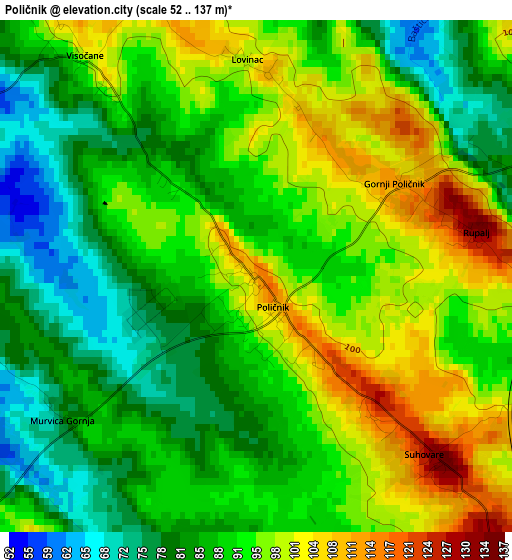
Below is the Elevation map of Poličnik, which displays elevation range with different colors. Scale of the first map is from 52 to 137 m (171 to 449 ft) with average elevation of 90.9 meters (=298 ft) [note 1]
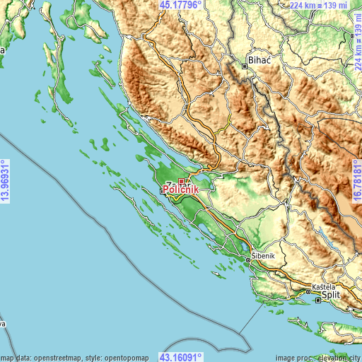
These maps also provides idea of topography and contour of this city, they are displayed at different zoom levels. More info about maps, scale and edge coordinates you can find below images.
| \ | Map #1 | Topo.Map |
| Scale [m] | 52..137 m | × |
| Scale [ft] | 171..449 ft | × |
| Average | 90.9 m = 298 ft | × |
| Width | 7.01 km = 4.4 mi | 224.3 km = 139.4 mi |
| Height | 7.01 km = 4.4 mi | 224.3 km = 139.4 mi |
| ↑Max Latitude | 44.209568° | 45.17796° |
| Latitude at center | 44.17806° | 44.17806° |
| ↓Min Latitude | 44.146535° | 43.16091° |
| ← Min Longitude | 15.331615° | 13.96931° |
| Longitude center | 15.37556° | 15.37556° |
| →Max Longitude | 15.419505° | 16.78181° |
Nearby cities:
Cities around Poličnik sort by population:
• Zadar elevation 19 m
12.5 km,  238°
238°
• Bibinje 8 m
13.8 km,  212°
212°
• Vrsi 55 m
14.9 km,  310°
310°
• Pridraga 85 m
15.3 km,  94°
94°
• Posedarje 17 m
9 km,  63°
63°
• Galovac 70 m
11.9 km,  173°
173°
• Starigrad 6 m
14 km,  20°
20°
• Ražanac 8 m
11.8 km,  349°
349°
• Sukošan 4 m
15 km,  198°
198°
• Novigrad 60 m
14.3 km, 87°
• Škabrnje 109 m
11.5 km,  147°
147°
• Zemunik Donji 81 m
7.9 km,  177°
177°
Multilingual:
 En español:
Poličnik elevación 117 m.
 En France:
Poličnik élévation 117 m.
 Auf Deutsch:
Poličnik höhe über dem Meeresspiegel ist 117 m.

Sources and notes:
- [note 1] Map square and city borders are not equal. Map elevation data is calculated only from area inside that square.
- [src 1] Elevation data from geonames database provided with same terms of usage.
- [src 2] The elevation map of Poličnik is generated using elevation data from NASA's 3 arcsec (90m) resolution SRTM data.
- [src 3] Base (background) map © OpenStreetMap contributors tiles are generated by Geofabrik and OpenTopoMap.
Copyright & License:
This Poličnik Elevation Map is licensed under CC BY-SA. You may reuse any part from this page, if you give a proper credit by linking to this URL:
 More info on terms of use page.