Pregrada elevation
Pregrada (Krapinsko-Zagorska), Croatia elevation is 187 meters and Pregrada elevation in feet is 614 ft above sea level [src 1]. Pregrada is a seat of a second-order administrative division (feature code) with elevation that is 33 meters (108 ft) bigger than average city elevation in Croatia.
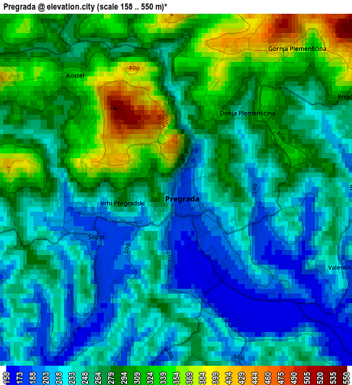
Below is the Elevation map of Pregrada, which displays elevation range with different colors. Scale of the first map is from 158 to 550 m (518 to 1804 ft) with average elevation of 265.9 meters (=872 ft) [note 1]
These maps also provides idea of topography and contour of this city, they are displayed at different zoom levels. More info about maps, scale and edge coordinates you can find below images.
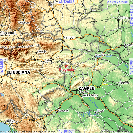
| \ | Map #1 | Topo.Map |
| Scale [m] | 158..550 m | × |
| Scale [ft] | 518..1804 ft | × |
| Average | 265.9 m = 872 ft | × |
| Width | 6.77 km = 4.2 mi | 216.6 km = 134.6 mi |
| Height | 6.77 km = 4.2 mi | 216.6 km = 134.6 mi |
| ↑Max Latitude | 46.194598° | 47.12951° |
| Latitude at center | 46.16417° | 46.16417° |
| ↓Min Latitude | 46.133725° | 45.18158° |
| ← Min Longitude | 15.706885° | 14.34458° |
| Longitude center | 15.75083° | 15.75083° |
| →Max Longitude | 15.794775° | 17.15708° |
Nearby cities:
Cities around Pregrada sort by population:
• Krapina elevation 237 m
9.9 km,  92°
92°
• Radoboj 257 m
13.3 km, 88°
• Klanjec 258 m
12.7 km,  182°
182°
• Gornje Jesenje 347 m
13.3 km,  69°
69°
• Zagorska Sela 225 m
11.6 km,  230°
230°
• Kumrovec 185 m
11.2 km,  211°
211°
• Krapinske Toplice 251 m
10.6 km,  137°
137°
• Tuhelj 169 m
9.7 km, 181°
• Ðurmanec 189 m
7.8 km,  62°
62°
• Hum na Sutli 338 m
7 km,  318°
318°
• Petrovsko 341 m
6.9 km, 86°
• Desinić 220 m
6.6 km,  254°
254°
Multilingual:
 En español:
Pregrada elevación 187 m.
 En France:
Pregrada élévation 187 m.
 Auf Deutsch:
Pregrada höhe über dem Meeresspiegel ist 187 m.

Sources and notes:
- [note 1] Map square and city borders are not equal. Map elevation data is calculated only from area inside that square.
- [src 1] Elevation data from geonames database provided with same terms of usage.
- [src 2] The elevation map of Pregrada is generated using elevation data from NASA's 3 arcsec (90m) resolution SRTM data.
- [src 3] Base (background) map © OpenStreetMap contributors tiles are generated by Geofabrik and OpenTopoMap.
Copyright & License:
This Pregrada Elevation Map is licensed under CC BY-SA. You may reuse any part from this page, if you give a proper credit by linking to this URL:
 More info on terms of use page.