Sinj elevation
Sinj (Split-Dalmatia, Grad Sinj), Croatia elevation is 322 meters and Sinj elevation in feet is 1056 ft above sea level [src 1]. Sinj is a seat of a second-order administrative division (feature code) with elevation that is 168 meters (551 ft) bigger than average city elevation in Croatia.
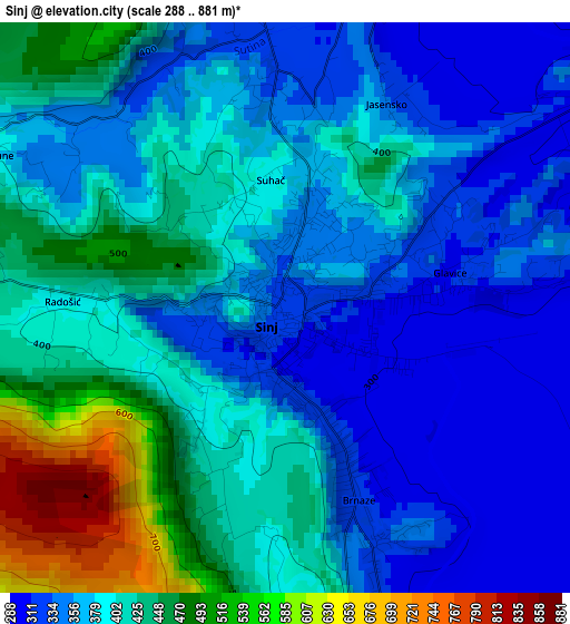
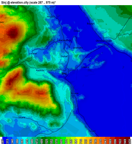
Below is the Elevation map of Sinj, which displays elevation range with different colors. Scale of the first map is from 288 to 881 m (945 to 2890 ft) with average elevation of 393.1 meters (=1290 ft) [note 1]
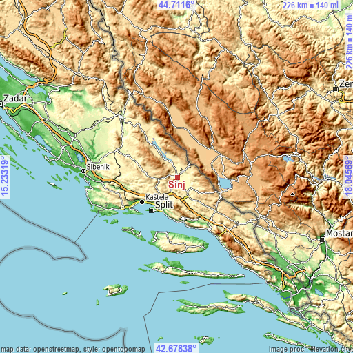
These maps also provides idea of topography and contour of this city, they are displayed at different zoom levels. More info about maps, scale and edge coordinates you can find below images.
| \ | Map #1 | Map #2 | Topo.Map |
| Scale [m] | 288..881 m | 287..975 m | × |
| Scale [ft] | 945..2890 ft | 942..3199 ft | × |
| Average | 393.1 m = 1290 ft | 429.8 m = 1410 ft | × |
| Width | 7.06 km = 4.4 mi | 14.13 km = 8.8 mi | 226.1 km = 140.5 mi |
| Height | 7.06 km = 4.4 mi | 14.13 km = 8.8 mi | 226.1 km = 140.5 mi |
| ↑Max Latitude | 43.735371° | 43.767115° | 44.7116° |
| Latitude at center | 43.70361° | 43.70361° | 43.70361° |
| ↓Min Latitude | 43.671832° | 43.640038° | 42.67838° |
| ← Min Longitude | 16.595495° | 16.551549° | 15.23319° |
| Longitude center | 16.63944° | 16.63944° | 16.63944° |
| →Max Longitude | 16.683385° | 16.727331° | 18.04569° |
Nearby cities:
Cities around Sinj sort by population:
• Brnaze elevation 325 m
2.8 km,  162°
162°
• Žrnovnica 48 m
21.3 km,  197°
197°
• Otok 323 m
7.8 km,  104°
104°
• Dugopolje 281 m
14 km,  192°
192°
• Klis 271 m
18.7 km,  211°
211°
• Trilj 309 m
11.7 km,  144°
144°
• Košute 341 m
9.2 km,  151°
151°
• Hrvace 357 m
6.9 km,  343°
343°
• Mravince 139 m
21.2 km, 206°
• Turjaci 317 m
6.4 km, 158°
• Gala 295 m
7.1 km,  79°
79°
• Greda 397 m
10.7 km, 156°
Multilingual:
 En español:
Sinj elevación 322 m.
 En France:
Sinj élévation 322 m.


Sources and notes:
- [note 1] Map square and city borders are not equal. Map elevation data is calculated only from area inside that square.
- [src 1] Elevation data from geonames database provided with same terms of usage.
- [src 2] The elevation map of Sinj is generated using elevation data from NASA's 3 arcsec (90m) resolution SRTM data.
- [src 3] Base (background) map © OpenStreetMap contributors tiles are generated by Geofabrik and OpenTopoMap.
Copyright & License:
This Sinj Elevation Map is licensed under CC BY-SA. You may reuse any part from this page, if you give a proper credit by linking to this URL:
 More info on terms of use page.