Virovitica elevation
Virovitica (Virovitičk-Podravska, Grad Virovitica), Croatia elevation is 123 meters and Virovitica elevation in feet is 404 ft above sea level [src 1]. Virovitica is a seat of a first-order administrative division (feature code) with elevation that is 31 meters (102 ft) smaller than average city elevation in Croatia.
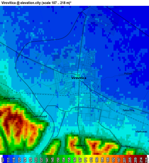
Below is the Elevation map of Virovitica, which displays elevation range with different colors. Scale of the first map is from 107 to 218 m (351 to 715 ft) with average elevation of 125.5 meters (=412 ft) [note 1]
These maps also provides idea of topography and contour of this city, they are displayed at different zoom levels. More info about maps, scale and edge coordinates you can find below images.
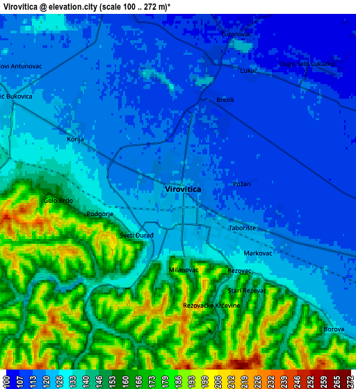

| \ | Map #1 | Map #2 | Topo.Map |
| Scale [m] | 107..218 m | 100..272 m | × |
| Scale [ft] | 351..715 ft | 328..892 ft | × |
| Average | 125.5 m = 412 ft | 136.7 m = 448 ft | × |
| Width | 6.81 km = 4.2 mi | 13.62 km = 8.5 mi | 217.9 km = 135.4 mi |
| Height | 6.81 km = 4.2 mi | 13.62 km = 8.5 mi | 217.9 km = 135.4 mi |
| ↑Max Latitude | 45.862551° | 45.893145° | 46.80314° |
| Latitude at center | 45.83194° | 45.83194° | 45.83194° |
| ↓Min Latitude | 45.801312° | 45.770667° | 44.84349° |
| ← Min Longitude | 17.339945° | 17.295999° | 15.97764° |
| Longitude center | 17.38389° | 17.38389° | 17.38389° |
| →Max Longitude | 17.427835° | 17.471781° | 18.79014° |
Nearby cities:
Cities around Virovitica sort by population:
• Pitomača elevation 111 m
17.8 km,  317°
317°
• Grubišno Polje 165 m
21.8 km,  228°
228°
• Suhopolje 117 m
9.6 km,  111°
111°
• Rezovac 219 m
6 km,  154°
154°
• Voćin 237 m
27 km, 151°
• Velika Pisanica 162 m
24.9 km,  262°
262°
• Gradina 121 m
9.9 km,  74°
74°
• Kloštar Podravski 117 m
24.2 km,  313°
313°
• Podravske Sesvete 112 m
23.4 km,  325°
325°
• Ðulovac 244 m
18.8 km,  168°
168°
• Špišić-Bukovica 126 m
7.1 km,  293°
293°
• Lukač 112 m
5.3 km,  31°
31°
Multilingual:
 En español:
Virovitica elevación 123 m.
 En France:
Virovitica élévation 123 m.
 Auf Deutsch:
Virovitica höhe über dem Meeresspiegel ist 123 m.

Sources and notes:
- [note 1] Map square and city borders are not equal. Map elevation data is calculated only from area inside that square.
- [src 1] Elevation data from geonames database provided with same terms of usage.
- [src 2] The elevation map of Virovitica is generated using elevation data from NASA's 3 arcsec (90m) resolution SRTM data.
- [src 3] Base (background) map © OpenStreetMap contributors tiles are generated by Geofabrik and OpenTopoMap.
Copyright & License:
This Virovitica Elevation Map is licensed under CC BY-SA. You may reuse any part from this page, if you give a proper credit by linking to this URL:
 More info on terms of use page.