Seget Vranjica elevation
Seget Vranjica (Split-Dalmatia, Seget), Croatia elevation is 19 meters and Seget Vranjica elevation in feet is 62 ft above sea level [src 1]. Seget Vranjica is a populated place (feature code) with elevation that is 135 meters (443 ft) smaller than average city elevation in Croatia.
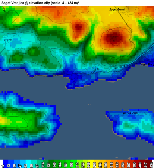
Below is the Elevation map of Seget Vranjica, which displays elevation range with different colors. Scale of the first map is from -4 to 434 m (-13 to 1424 ft) with average elevation of 150.1 meters (=492 ft) [note 1]
These maps also provides idea of topography and contour of this city, they are displayed at different zoom levels. More info about maps, scale and edge coordinates you can find below images.
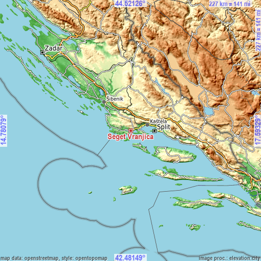
| \ | Map #1 | Topo.Map |
| Scale [m] | -4..434 m | × |
| Scale [ft] | -13..1424 ft | × |
| Average | 150.1 m = 492 ft | × |
| Width | 7.09 km = 4.4 mi | 226.8 km = 140.9 mi |
| Height | 7.09 km = 4.4 mi | 226.8 km = 140.9 mi |
| ↑Max Latitude | 43.541853° | 44.52126° |
| Latitude at center | 43.50999° | 43.50999° |
| ↓Min Latitude | 43.47811° | 42.48149° |
| ← Min Longitude | 16.143095° | 14.78079° |
| Longitude center | 16.18704° | 16.18704° |
| →Max Longitude | 16.230985° | 17.59329° |
Nearby cities:
Cities around Seget Vranjica sort by population:
• Trogir elevation 20 m
5.2 km,  86°
86°
• Kaštel Stari 25 m
13.9 km,  71°
71°
• Kaštel Novi 5 m
12.6 km, 69°
• Kaštel Lukšić 19 m
15.4 km, 70°
• Okrug Gornji 40 m
6.5 km,  105°
105°
• Kaštel Štafilić 5 m
12.6 km, 69°
• Veliki Drvenik 48 m
7.3 km,  204°
204°
• Slatine 25 m
11.9 km,  95°
95°
• Primorski Dolac 156 m
13.5 km,  356°
356°
• Prgomet 344 m
11.2 km,  17°
17°
• Marina 15 m
6.5 km,  274°
274°
• Donji Seget -1 m
3.8 km,  78°
78°
Multilingual:
 En español:
Seget Vranjica elevación 19 m.
 En France:
Seget Vranjica élévation 19 m.
 Auf Deutsch:
Seget Vranjica höhe über dem Meeresspiegel ist 19 m.

Sources and notes:
- [note 1] Map square and city borders are not equal. Map elevation data is calculated only from area inside that square.
- [src 1] Elevation data from geonames database provided with same terms of usage.
- [src 2] The elevation map of Seget Vranjica is generated using elevation data from NASA's 3 arcsec (90m) resolution SRTM data.
- [src 3] Base (background) map © OpenStreetMap contributors tiles are generated by Geofabrik and OpenTopoMap.
Copyright & License:
This Seget Vranjica Elevation Map is licensed under CC BY-SA. You may reuse any part from this page, if you give a proper credit by linking to this URL:
 More info on terms of use page.