Santa Cruz de Yojoa elevation
Santa Cruz de Yojoa (Cortés), Honduras elevation is 493 meters and Santa Cruz de Yojoa elevation in feet is 1617 ft above sea level [src 1]. Santa Cruz de Yojoa is a populated place (feature code) with elevation that is 50 meters (164 ft) smaller than average city elevation in Honduras.
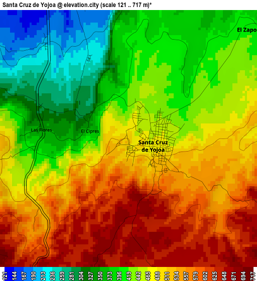
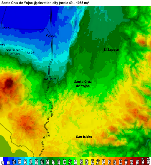
Below is the Elevation map of Santa Cruz de Yojoa, which displays elevation range with different colors. Scale of the first map is from 121 to 717 m (397 to 2352 ft) with average elevation of 465 meters (=1526 ft) [note 1]
These maps also provides idea of topography and contour of this city, they are displayed at different zoom levels. More info about maps, scale and edge coordinates you can find below images.
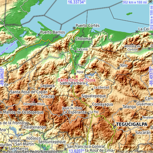
| \ | Map #1 | Map #2 | Topo.Map |
| Scale [m] | 121..717 m | 49..1065 m | × |
| Scale [ft] | 397..2352 ft | 161..3494 ft | × |
| Average | 465 m = 1526 ft | 485.9 m = 1594 ft | × |
| Width | 9.44 km = 5.9 mi | 18.88 km = 11.7 mi | 302.1 km = 187.7 mi |
| Height | 9.44 km = 5.9 mi | 18.88 km = 11.7 mi | 302.1 km = 187.7 mi |
| ↑Max Latitude | 15.025777° | 15.068216° | 16.33734° |
| Latitude at center | 14.98333° | 14.98333° | 14.98333° |
| ↓Min Latitude | 14.940875° | 14.898411° | 13.6207° |
| ← Min Longitude | -87.943945° | -87.987891° | -89.30625° |
| Longitude center | -87.9° | -87.9° | -87.9° |
| →Max Longitude | -87.856055° | -87.812109° | -86.49375° |
Nearby cities:
Cities around Santa Cruz de Yojoa sort by population:
• Río Lindo elevation 145 m
10.5 km,  301°
301°
• Cañaveral 506 m
12.5 km,  270°
270°
• San Francisco de Yojoa 262 m
8.1 km, 297°
• San Buenaventura 414 m
11.4 km,  289°
289°
• El Tigre 649 m
10.5 km,  238°
238°
• Oropéndolas 165 m
5.2 km,  316°
316°
• El Olivar 244 m
11.3 km,  9°
9°
• Bejuco 47 m
17.1 km,  347°
347°
• La Guama 664 m
11.7 km,  197°
197°
• Los Caminos 724 m
8.1 km, 242°
• Agua Azul 705 m
10.3 km,  224°
224°
• Agua Azul Rancho 648 m
10.7 km,  210°
210°
Multilingual:
 En español:
Santa Cruz de Yojoa elevación 493 m.
 En France:
Santa Cruz de Yojoa élévation 493 m.
 Auf Deutsch:
Santa Cruz de Yojoa höhe über dem Meeresspiegel ist 493 m.
 На русском:
Santa Cruz de Yojoa высота над уровнем моря 493 м
Sources and notes:
- [note 1] Map square and city borders are not equal. Map elevation data is calculated only from area inside that square.
- [src 1] Elevation data from geonames database provided with same terms of usage.
- [src 2] The elevation map of Santa Cruz de Yojoa is generated using elevation data from NASA's 3 arcsec (90m) resolution SRTM data.
- [src 3] Base (background) map © OpenStreetMap contributors tiles are generated by Geofabrik and OpenTopoMap.
Copyright & License:
This Santa Cruz de Yojoa Elevation Map is licensed under CC BY-SA. You may reuse any part from this page, if you give a proper credit by linking to this URL:
 More info on terms of use page.