Yoro elevation
Yoro, Honduras elevation is 648 meters and Yoro elevation in feet is 2126 ft above sea level [src 1]. Yoro is a seat of a first-order administrative division (feature code) with elevation that is 105 meters (344 ft) bigger than average city elevation in Honduras.
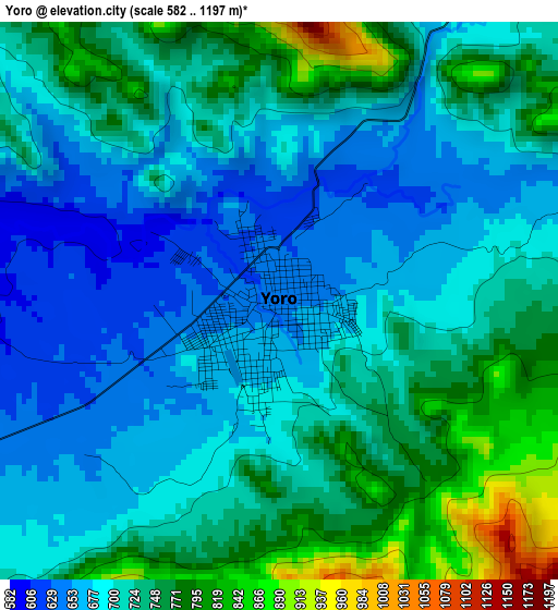
Below is the Elevation map of Yoro, which displays elevation range with different colors. Scale of the first map is from 582 to 1197 m (1909 to 3927 ft) with average elevation of 716.1 meters (=2349 ft) [note 1]
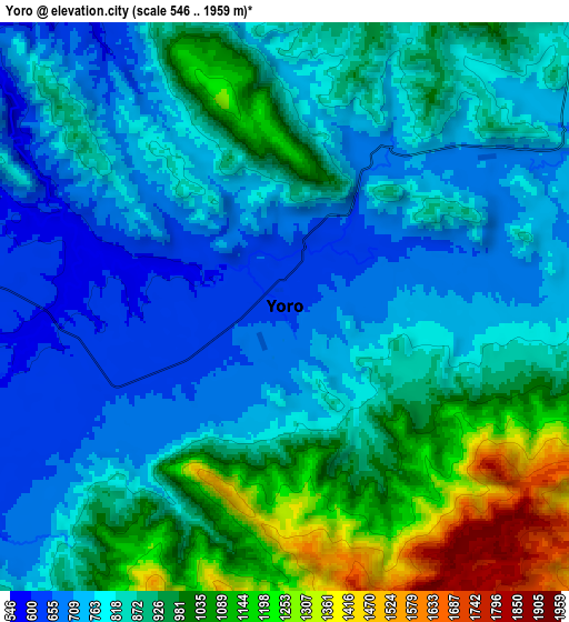
These maps also provides idea of topography and contour of this city, they are displayed at different zoom levels. More info about maps, scale and edge coordinates you can find below images.
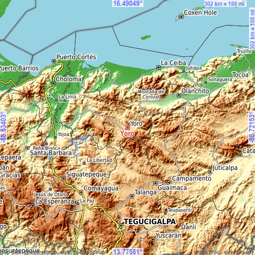
| \ | Map #1 | Map #2 | Topo.Map |
| Scale [m] | 582..1197 m | 546..1959 m | × |
| Scale [ft] | 1909..3927 ft | 1791..6427 ft | × |
| Average | 716.1 m = 2349 ft | 871 m = 2858 ft | × |
| Width | 9.43 km = 5.9 mi | 18.87 km = 11.7 mi | 301.8 km = 187.5 mi |
| Height | 9.43 km = 5.9 mi | 18.87 km = 11.7 mi | 301.9 km = 187.6 mi |
| ↑Max Latitude | 15.179916° | 15.222324° | 16.49049° |
| Latitude at center | 15.1375° | 15.1375° | 15.1375° |
| ↓Min Latitude | 15.095075° | 15.052642° | 13.77581° |
| ← Min Longitude | -87.171725° | -87.215671° | -88.53403° |
| Longitude center | -87.12778° | -87.12778° | -87.12778° |
| →Max Longitude | -87.083835° | -87.039889° | -85.72153° |
Nearby cities:
Cities around Yoro sort by population:
• Santa Rita elevation 885 m
17 km,  280°
280°
• Yorito 787 m
18.5 km,  244°
244°
• San José 584 m
20.4 km,  348°
348°
• Jocón 973 m
23.7 km,  46°
46°
• San Antonio 577 m
21.9 km, 353°
• Ayapa 642 m
5.9 km, 240°
• La Rosa 866 m
24.5 km,  15°
15°
• Lomitas 613 m
10.4 km,  246°
246°
• Marale 758 m
28.4 km,  184°
184°
• Punta Ocote 692 m
18.1 km,  292°
292°
• La Trinidad 625 m
8.8 km, 241°
• Paujiles 1324 m
24.2 km,  260°
260°
Multilingual:
 En español:
Yoro elevación 648 m.
 En France:
Yoro élévation 648 m.


Sources and notes:
- [note 1] Map square and city borders are not equal. Map elevation data is calculated only from area inside that square.
- [src 1] Elevation data from geonames database provided with same terms of usage.
- [src 2] The elevation map of Yoro is generated using elevation data from NASA's 3 arcsec (90m) resolution SRTM data.
- [src 3] Base (background) map © OpenStreetMap contributors tiles are generated by Geofabrik and OpenTopoMap.
Copyright & License:
This Yoro Elevation Map is licensed under CC BY-SA. You may reuse any part from this page, if you give a proper credit by linking to this URL:
 More info on terms of use page.