Puerto Cortez elevation
Puerto Cortez (Cortés), Honduras elevation is 10 meters and Puerto Cortez elevation in feet is 33 ft above sea level [src 1]. Puerto Cortez is a populated place (feature code) with elevation that is 533 meters (1749 ft) smaller than average city elevation in Honduras.
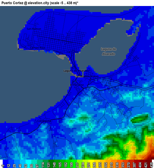
Below is the Elevation map of Puerto Cortez, which displays elevation range with different colors. Scale of the first map is from -5 to 438 m (-16 to 1437 ft) with average elevation of 42.1 meters (=138 ft) [note 1]
These maps also provides idea of topography and contour of this city, they are displayed at different zoom levels. More info about maps, scale and edge coordinates you can find below images.
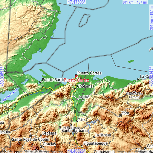
| \ | Map #1 | Map #2 | Topo.Map |
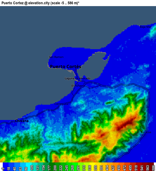
| Scale [m] | -5..438 m | -5..586 m | × |
| Scale [ft] | -16..1437 ft | -16..1923 ft | × |
| Average | 42.1 m = 138 ft | 111.4 m = 365 ft | × |
| Width | 9.4 km = 5.8 mi | 18.8 km = 11.7 mi | 300.8 km = 186.9 mi |
| Height | 9.4 km = 5.8 mi | 18.8 km = 11.7 mi | 300.9 km = 187 mi |
| ↑Max Latitude | 15.867895° | 15.910162° | 17.17393° |
| Latitude at center | 15.82562° | 15.82562° | 15.82562° |
| ↓Min Latitude | 15.783336° | 15.741043° | 14.46826° |
| ← Min Longitude | -87.973625° | -88.017571° | -89.33593° |
| Longitude center | -87.92968° | -87.92968° | -87.92968° |
| →Max Longitude | -87.885735° | -87.841789° | -86.52343° |
Nearby cities:
Cities around Puerto Cortez sort by population:
• Choloma elevation 41 m
23.6 km,  186°
186°
• Baracoa 9 m
10.8 km,  127°
127°
• Omoa 54 m
12.9 km,  239°
239°
• La Jutosa 156 m
22.7 km,  199°
199°
• El Porvenir 5 m
0.9 km,  335°
335°
• Río Blanquito 77 m
10.7 km,  162°
162°
• Quebrada Seca 89 m
17.8 km, 187°
• Puerto Alto 11 m
15.5 km,  154°
154°
• Travesía 6 m
5.6 km,  34°
34°
• El Rancho 89 m
17.8 km, 187°
• Baja Mar 3 m
10.6 km,  48°
48°
• Chivana 222 m
10.2 km,  214°
214°
Multilingual:
 En español:
Puerto Cortés elevación 10 m.
 En France:
Puerto Cortez élévation 10 m.
 Auf Deutsch:
Puerto Cortez höhe über dem Meeresspiegel ist 10 m.

Sources and notes:
- [note 1] Map square and city borders are not equal. Map elevation data is calculated only from area inside that square.
- [src 1] Elevation data from geonames database provided with same terms of usage.
- [src 2] The elevation map of Puerto Cortez is generated using elevation data from NASA's 3 arcsec (90m) resolution SRTM data.
- [src 3] Base (background) map © OpenStreetMap contributors tiles are generated by Geofabrik and OpenTopoMap.
Copyright & License:
This Puerto Cortez Elevation Map is licensed under CC BY-SA. You may reuse any part from this page, if you give a proper credit by linking to this URL:
 More info on terms of use page.