Tai Po elevation
Tai Po, Hong Kong elevation is 22 meters and Tai Po elevation in feet is 72 ft above sea level [src 1]. Tai Po is a seat of a first-order administrative division (feature code) with elevation that is 50 meters (164 ft) smaller than average city elevation in Hong Kong.
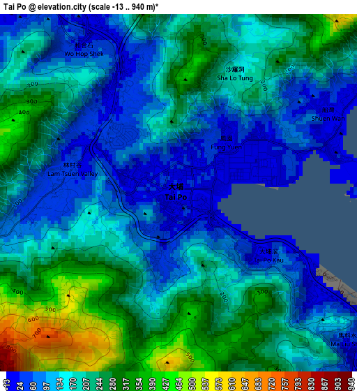
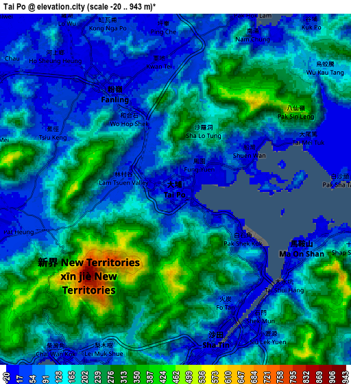
Below is the Elevation map of Tai Po, which displays elevation range with different colors. Scale of the first map is from -13 to 940 m (-43 to 3084 ft) with average elevation of 181.7 meters (=596 ft) [note 1]
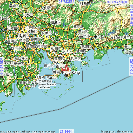
These maps also provides idea of topography and contour of this city, they are displayed at different zoom levels. More info about maps, scale and edge coordinates you can find below images.
| \ | Map #1 | Map #2 | Topo.Map |
| Scale [m] | -13..940 m | -20..943 m | × |
| Scale [ft] | -43..3084 ft | -66..3094 ft | × |
| Average | 181.7 m = 596 ft | 166.4 m = 546 ft | × |
| Width | 9.03 km = 5.6 mi | 18.06 km = 11.2 mi | 289 km = 179.6 mi |
| Height | 9.03 km = 5.6 mi | 18.06 km = 11.2 mi | 289 km = 179.6 mi |
| ↑Max Latitude | 22.490679° | 22.531276° | 23.74356° |
| Latitude at center | 22.45007° | 22.45007° | 22.45007° |
| ↓Min Latitude | 22.409449° | 22.368817° | 21.1444° |
| ← Min Longitude | 114.124825° | 114.080879° | 112.76252° |
| Longitude center | 114.16877° | 114.16877° | 114.16877° |
| →Max Longitude | 114.212715° | 114.256661° | 115.57502° |
Nearby cities:
Cities around Tai Po sort by population:
• Hong Kong elevation 60 m
19.1 km,  178°
178°
• Kowloon 92 m
14.9 km,  174°
174°
• Tsuen Wan 1 m
10.4 km,  213°
213°
• Yuen Long Kau Hui 4 m
13.9 km,  269°
269°
• Sha Tin 115 m
7.6 km, 168°
• Tuen Mun 7 m
21.3 km,  252°
252°
• Sai Kung 54 m
12.5 km,  126°
126°
• Yung Shue Wan 19 m
25.6 km,  193°
193°
• Wan Chai 40 m
18.8 km, 178°
• Central 29 m
18.6 km, 183°
• Sham Shui Po 10 m
13.4 km, 184°
• Wong Tai Sin 253 m
11.2 km, 172°
Multilingual:
 En español:
Tai Po elevación 22 m.
 En France:
Tai Po élévation 22 m.


Sources and notes:
- [note 1] Map square and city borders are not equal. Map elevation data is calculated only from area inside that square.
- [src 1] Elevation data from geonames database provided with same terms of usage.
- [src 2] The elevation map of Tai Po is generated using elevation data from NASA's 3 arcsec (90m) resolution SRTM data.
- [src 3] Base (background) map © OpenStreetMap contributors tiles are generated by Geofabrik and OpenTopoMap.
Copyright & License:
This Tai Po Elevation Map is licensed under CC BY-SA. You may reuse any part from this page, if you give a proper credit by linking to this URL:
 More info on terms of use page.