Tamuning elevation
Tamuning, Guam elevation is 20 meters and Tamuning elevation in feet is 66 ft above sea level [src 1]. Tamuning is a section of populated place (feature code) with elevation that is 23 meters (75 ft) smaller than average city elevation in Guam.
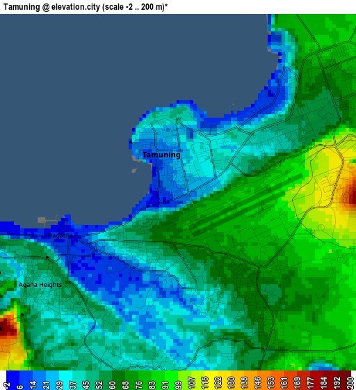
Below is the Elevation map of Tamuning, which displays elevation range with different colors. Scale of the first map is from -2 to 200 m (-7 to 656 ft) with average elevation of 57 meters (=187 ft) [note 1]
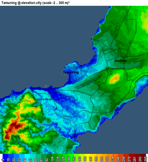
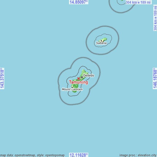
These maps also provides idea of topography and contour of this city, they are displayed at different zoom levels. More info about maps, scale and edge coordinates you can find below images.
| \ | Map #1 | Map #2 | Topo.Map |
| Scale [m] | -2..200 m | -2..305 m | × |
| Scale [ft] | -7..656 ft | -7..1001 ft | × |
| Average | 57 m = 187 ft | 88.7 m = 291 ft | × |
| Width | 9.5 km = 5.9 mi | 19.01 km = 11.8 mi | 304.1 km = 189 mi |
| Height | 9.5 km = 5.9 mi | 19.01 km = 11.8 mi | 304.1 km = 189 mi |
| ↑Max Latitude | 13.53027° | 13.572991° | 14.85097° |
| Latitude at center | 13.48754° | 13.48754° | 13.48754° |
| ↓Min Latitude | 13.444803° | 13.402058° | 12.11628° |
| ← Min Longitude | 144.737485° | 144.693539° | 143.37518° |
| Longitude center | 144.78143° | 144.78143° | 144.78143° |
| →Max Longitude | 144.825375° | 144.869321° | 146.18768° |
Nearby cities:
Cities around Tamuning sort by population:
• Dededo Village elevation 100 m
7.1 km,  61°
61°
• Tamuning-Tumon-Harmon Village 20 m
0 km,  345°
345°
• Mangilao Village 58 m
4.9 km,  154°
154°
• Barrigada Village 68 m
2.8 km,  137°
137°
• Mongmong-Toto-Maite Village 46 m
2.1 km,  177°
177°
• Chalan Pago-Ordot Village 46 m
5.1 km,  208°
208°
• Agana Heights Village 39 m
4.4 km,  236°
236°
• Sinajana Village 51 m
4 km,  227°
227°
• Asan-Maina Village 5 m
7.2 km,  256°
256°
• Hagåtña 5 m
3.8 km,  249°
249°
• Hagåtña Village 8 m
3 km, 237°
• Guam Government House 46 m
3.8 km, 243°
Multilingual:
 En español:
Tamuning elevación 20 m.
 En France:
Tamuning élévation 20 m.


Sources and notes:
- [note 1] Map square and city borders are not equal. Map elevation data is calculated only from area inside that square.
- [src 1] Elevation data from geonames database provided with same terms of usage.
- [src 2] The elevation map of Tamuning is generated using elevation data from NASA's 3 arcsec (90m) resolution SRTM data.
- [src 3] Base (background) map © OpenStreetMap contributors tiles are generated by Geofabrik and OpenTopoMap.
Copyright & License:
This Tamuning Elevation Map is licensed under CC BY-SA. You may reuse any part from this page, if you give a proper credit by linking to this URL:
 More info on terms of use page.