Santa Rita Village elevation
Santa Rita Village (Santa Rita), Guam elevation is 77 meters and Santa Rita Village elevation in feet is 253 ft above sea level [src 1]. Santa Rita Village is a seat of a first-order administrative division (feature code) with elevation that is 34 meters (112 ft) bigger than average city elevation in Guam.
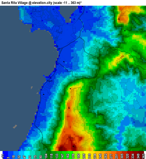
Below is the Elevation map of Santa Rita Village, which displays elevation range with different colors. Scale of the first map is from -11 to 363 m (-36 to 1191 ft) with average elevation of 90.5 meters (=297 ft) [note 1]
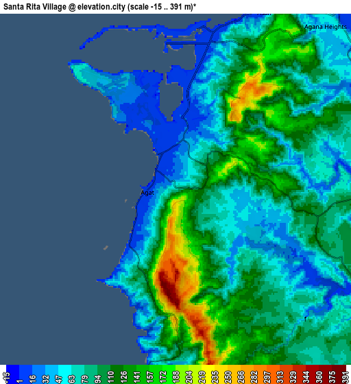
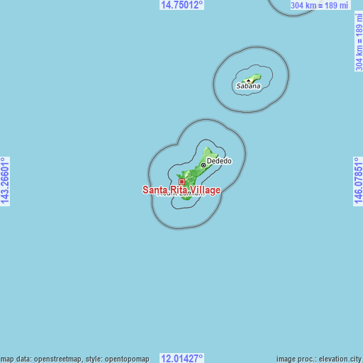
These maps also provides idea of topography and contour of this city, they are displayed at different zoom levels. More info about maps, scale and edge coordinates you can find below images.
| \ | Map #1 | Map #2 | Topo.Map |
| Scale [m] | -11..363 m | -15..391 m | × |
| Scale [ft] | -36..1191 ft | -49..1283 ft | × |
| Average | 90.5 m = 297 ft | 92.9 m = 305 ft | × |
| Width | 9.51 km = 5.9 mi | 19.01 km = 11.8 mi | 304.2 km = 189 mi |
| Height | 9.51 km = 5.9 mi | 19.01 km = 11.8 mi | 304.2 km = 189 mi |
| ↑Max Latitude | 13.428828° | 13.471568° | 14.75012° |
| Latitude at center | 13.38608° | 13.38608° | 13.38608° |
| ↓Min Latitude | 13.343325° | 13.300562° | 12.01427° |
| ← Min Longitude | 144.628315° | 144.584369° | 143.26601° |
| Longitude center | 144.67226° | 144.67226° | 144.67226° |
| →Max Longitude | 144.716205° | 144.760151° | 146.07851° |
Nearby cities:
Cities around Santa Rita Village sort by population:
• Chalan Pago-Ordot Village elevation 46 m
11.6 km,  53°
53°
• Yona Village 92 m
11.6 km,  76°
76°
• Agat Village 0 m
1.5 km,  280°
280°
• Agana Heights Village 39 m
12 km,  42°
42°
• Talofofo Village 101 m
9.9 km,  110°
110°
• Sinajana Village 51 m
12.3 km, 45°
• Asan-Maina Village 5 m
10.7 km,  26°
26°
• Piti Village 8 m
8.8 km,  14°
14°
• Hagåtña Village 8 m
13.4 km, 43°
• Hagåtña 5 m
13 km, 39°
• Umatac Village 6 m
9.8 km,  185°
185°
• Guam Government House 46 m
12.7 km, 41°
Multilingual:
 En español:
Santa Rita Village elevación 77 m.
 En France:
Santa Rita Village élévation 77 m.
 Auf Deutsch:
Santa Rita Village höhe über dem Meeresspiegel ist 77 m.

Sources and notes:
- [note 1] Map square and city borders are not equal. Map elevation data is calculated only from area inside that square.
- [src 1] Elevation data from geonames database provided with same terms of usage.
- [src 2] The elevation map of Santa Rita Village is generated using elevation data from NASA's 3 arcsec (90m) resolution SRTM data.
- [src 3] Base (background) map © OpenStreetMap contributors tiles are generated by Geofabrik and OpenTopoMap.
Copyright & License:
This Santa Rita Village Elevation Map is licensed under CC BY-SA. You may reuse any part from this page, if you give a proper credit by linking to this URL:
 More info on terms of use page.