San Andrés elevation
San Andrés (Petén, Municipio de San Andrés), Guatemala elevation is 132 meters and San Andrés elevation in feet is 433 ft above sea level [src 1]. San Andrés is a seat of a second-order administrative division (feature code) with elevation that is 1135 meters (3724 ft) smaller than average city elevation in Guatemala.
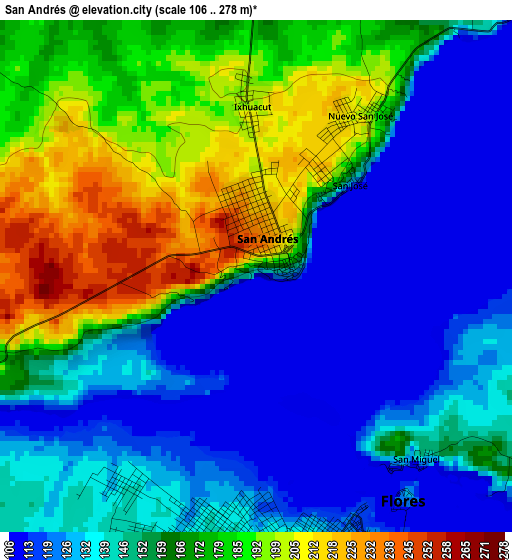
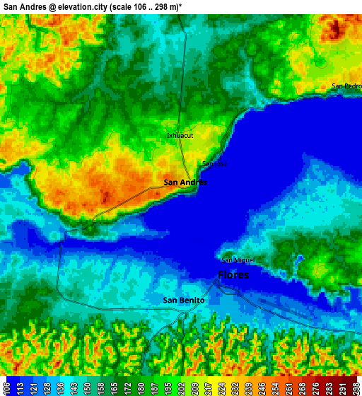
Below is the Elevation map of San Andrés, which displays elevation range with different colors. Scale of the first map is from 106 to 278 m (348 to 912 ft) with average elevation of 155.3 meters (=510 ft) [note 1]
These maps also provides idea of topography and contour of this city, they are displayed at different zoom levels. More info about maps, scale and edge coordinates you can find below images.
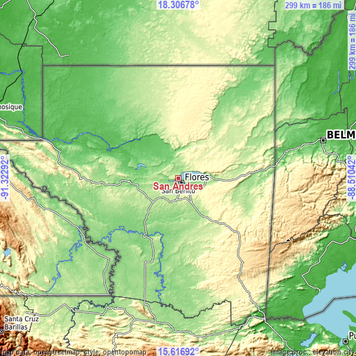
| \ | Map #1 | Map #2 | Topo.Map |
| Scale [m] | 106..278 m | 106..298 m | × |
| Scale [ft] | 348..912 ft | 348..978 ft | × |
| Average | 155.3 m = 510 ft | 165.9 m = 544 ft | × |
| Width | 9.35 km = 5.8 mi | 18.69 km = 11.6 mi | 299.1 km = 185.9 mi |
| Height | 9.35 km = 5.8 mi | 18.69 km = 11.6 mi | 299.1 km = 185.9 mi |
| ↑Max Latitude | 17.008698° | 17.050716° | 18.30678° |
| Latitude at center | 16.96667° | 16.96667° | 16.96667° |
| ↓Min Latitude | 16.924633° | 16.882586° | 15.61692° |
| ← Min Longitude | -89.960615° | -90.004561° | -91.32292° |
| Longitude center | -89.91667° | -89.91667° | -89.91667° |
| →Max Longitude | -89.872725° | -89.828779° | -88.51042° |
Nearby cities:
Cities around San Andrés sort by population:
• San Benito elevation 135 m
5.6 km,  182°
182°
• Flores 121 m
5.2 km,  159°
159°
• Poptún 533 m
88.5 km,  143°
143°
• Melchor de Mencos 113 m
82 km,  82°
82°
• Dolores 446 m
73.4 km,  133°
133°
• Santa Ana 213 m
20.5 km,  154°
154°
• Sayaxché 134 m
57 km,  210°
210°
• La Libertad 186 m
29.1 km,  227°
227°
• San Luis 381 m
99.3 km, 149°
• San Francisco 218 m
18.6 km,  185°
185°
• San José 147 m
2.6 km,  43°
43°
• El Chal 265 m
45.7 km, 142°
Multilingual:
 En español:
San Andrés elevación 132 m.
 En France:
San Andrés élévation 132 m.
 Auf Deutsch:
San Andrés höhe über dem Meeresspiegel ist 132 m.

Sources and notes:
- [note 1] Map square and city borders are not equal. Map elevation data is calculated only from area inside that square.
- [src 1] Elevation data from geonames database provided with same terms of usage.
- [src 2] The elevation map of San Andrés is generated using elevation data from NASA's 3 arcsec (90m) resolution SRTM data.
- [src 3] Base (background) map © OpenStreetMap contributors tiles are generated by Geofabrik and OpenTopoMap.
Copyright & License:
This San Andrés Elevation Map is licensed under CC BY-SA. You may reuse any part from this page, if you give a proper credit by linking to this URL:
 More info on terms of use page.