San Cristóbal Cucho elevation
San Cristóbal Cucho (San Marcos), Guatemala elevation is 2350 meters and San Cristóbal Cucho elevation in feet is 7710 ft above sea level [src 1]. San Cristóbal Cucho is a seat of a second-order administrative division (feature code) with elevation that is 1083 meters (3553 ft) bigger than average city elevation in Guatemala.
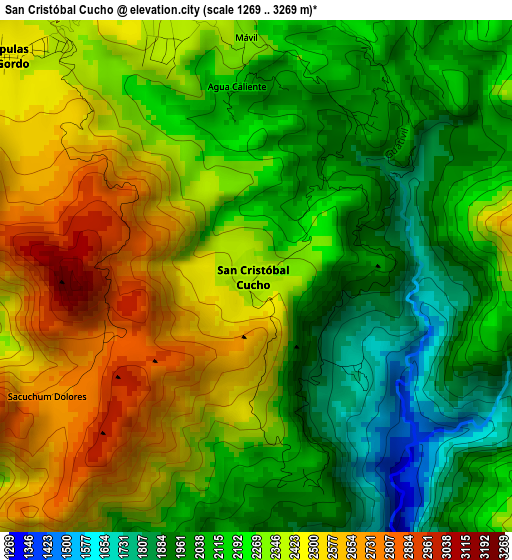
Below is the Elevation map of San Cristóbal Cucho, which displays elevation range with different colors. Scale of the first map is from 1269 to 3269 m (4163 to 10725 ft) with average elevation of 2261.9 meters (=7421 ft) [note 1]
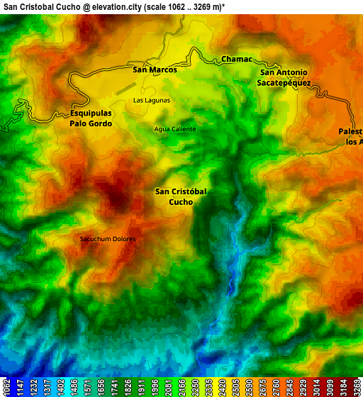
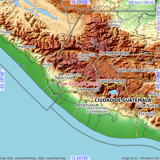
These maps also provides idea of topography and contour of this city, they are displayed at different zoom levels. More info about maps, scale and edge coordinates you can find below images.
| \ | Map #1 | Map #2 | Topo.Map |
| Scale [m] | 1269..3269 m | 1062..3269 m | × |
| Scale [ft] | 4163..10725 ft | 3484..10725 ft | × |
| Average | 2261.9 m = 7421 ft | 2236.3 m = 7337 ft | × |
| Width | 9.44 km = 5.9 mi | 18.89 km = 11.7 mi | 302.2 km = 187.8 mi |
| Height | 9.44 km = 5.9 mi | 18.89 km = 11.7 mi | 302.2 km = 187.8 mi |
| ↑Max Latitude | 14.947513° | 14.989967° | 16.25958° |
| Latitude at center | 14.90505° | 14.90505° | 14.90505° |
| ↓Min Latitude | 14.862579° | 14.8201° | 13.54195° |
| ← Min Longitude | -91.825175° | -91.869121° | -93.18748° |
| Longitude center | -91.78123° | -91.78123° | -91.78123° |
| →Max Longitude | -91.737285° | -91.693339° | -90.37498° |
Nearby cities:
Cities around San Cristóbal Cucho sort by population:
• San Pedro Sacatepéquez elevation 2412 m
7.3 km,  16°
16°
• San Marcos 2380 m
6.7 km,  347°
347°
• El Quetzal 784 m
15.7 km,  194°
194°
• El Tumbador 867 m
17.1 km,  254°
254°
• La Reforma 1127 m
12.4 km,  200°
200°
• San Rafael Pie de la Cuesta 1044 m
14.5 km,  281°
281°
• San Martín Sacatepéquez 2505 m
17.4 km,  120°
120°
• Palestina de los Altos 2627 m
9.9 km,  71°
71°
• San Antonio Sacatepéquez 2410 m
8.2 km,  40°
40°
• Esquipulas Palo Gordo 2475 m
6.2 km,  310°
310°
• San Lorenzo 2644 m
14.8 km, 19°
• San Juan Ostuncalco 2791 m
10.5 km,  109°
109°
Multilingual:
 En español:
San Cristóbal Cucho elevación 2350 m.
 En France:
San Cristóbal Cucho élévation 2350 m.
 Auf Deutsch:
San Cristóbal Cucho höhe über dem Meeresspiegel ist 2350 m.
 На русском:
San Cristóbal Cucho высота над уровнем моря 2350 м
Sources and notes:
- [note 1] Map square and city borders are not equal. Map elevation data is calculated only from area inside that square.
- [src 1] Elevation data from geonames database provided with same terms of usage.
- [src 2] The elevation map of San Cristóbal Cucho is generated using elevation data from NASA's 3 arcsec (90m) resolution SRTM data.
- [src 3] Base (background) map © OpenStreetMap contributors tiles are generated by Geofabrik and OpenTopoMap.
Copyright & License:
This San Cristóbal Cucho Elevation Map is licensed under CC BY-SA. You may reuse any part from this page, if you give a proper credit by linking to this URL:
 More info on terms of use page.