Tactic elevation
Tactic (Alta Verapaz, Municipio de Tactic), Guatemala elevation is 1456 meters and Tactic elevation in feet is 4777 ft above sea level [src 1]. Tactic is a populated place (feature code) with elevation that is 189 meters (620 ft) bigger than average city elevation in Guatemala.
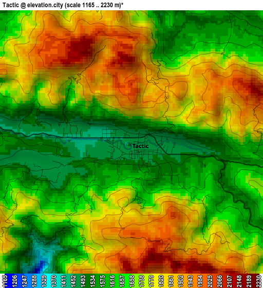
Below is the Elevation map of Tactic, which displays elevation range with different colors. Scale of the first map is from 1165 to 2230 m (3822 to 7316 ft) with average elevation of 1728.2 meters (=5670 ft) [note 1]
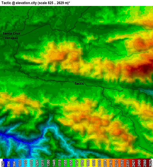
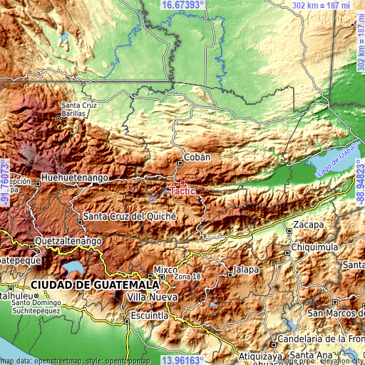
These maps also provides idea of topography and contour of this city, they are displayed at different zoom levels. More info about maps, scale and edge coordinates you can find below images.
| \ | Map #1 | Map #2 | Topo.Map |
| Scale [m] | 1165..2230 m | 825..2629 m | × |
| Scale [ft] | 3822..7316 ft | 2707..8625 ft | × |
| Average | 1728.2 m = 5670 ft | 1636.1 m = 5368 ft | × |
| Width | 9.43 km = 5.9 mi | 18.85 km = 11.7 mi | 301.6 km = 187.4 mi |
| Height | 9.43 km = 5.9 mi | 18.85 km = 11.7 mi | 301.6 km = 187.4 mi |
| ↑Max Latitude | 15.364559° | 15.406929° | 16.67393° |
| Latitude at center | 15.32218° | 15.32218° | 15.32218° |
| ↓Min Latitude | 15.279792° | 15.237396° | 13.96163° |
| ← Min Longitude | -90.398425° | -90.442371° | -91.76073° |
| Longitude center | -90.35448° | -90.35448° | -90.35448° |
| →Max Longitude | -90.310535° | -90.266589° | -88.94823° |
Nearby cities:
Cities around Tactic sort by population:
• Cobán elevation 1329 m
16.6 km,  353°
353°
• Salamá 946 m
24.7 km,  170°
170°
• San Cristóbal Verapaz 2149 m
24 km,  290°
290°
• San Miguel Chicaj 945 m
25.7 km,  189°
189°
• San Pedro Carchá 1278 m
20.2 km,  27°
27°
• San Juan Chamelco 1408 m
12.6 km,  10°
10°
• Rabinal 969 m
30.2 km,  209°
209°
• San Jerónimo 1001 m
31.6 km,  157°
157°
• Santa Cruz Verapaz 1420 m
9.8 km,  300°
300°
• Purulhá 2084 m
17.7 km,  110°
110°
• Tucurú 570 m
31 km,  94°
94°
• Tamahú 1095 m
12.8 km,  96°
96°
Multilingual:
 En español:
Tactic elevación 1456 m.
 En France:
Tactic élévation 1456 m.


Sources and notes:
- [note 1] Map square and city borders are not equal. Map elevation data is calculated only from area inside that square.
- [src 1] Elevation data from geonames database provided with same terms of usage.
- [src 2] The elevation map of Tactic is generated using elevation data from NASA's 3 arcsec (90m) resolution SRTM data.
- [src 3] Base (background) map © OpenStreetMap contributors tiles are generated by Geofabrik and OpenTopoMap.
Copyright & License:
This Tactic Elevation Map is licensed under CC BY-SA. You may reuse any part from this page, if you give a proper credit by linking to this URL:
 More info on terms of use page.