Tajumulco elevation
Tajumulco (San Marcos), Guatemala elevation is 2066 meters and Tajumulco elevation in feet is 6778 ft above sea level [src 1]. Tajumulco is a seat of a second-order administrative division (feature code) with elevation that is 799 meters (2621 ft) bigger than average city elevation in Guatemala.
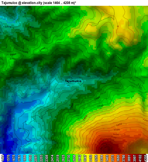
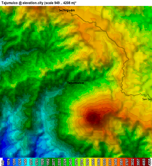
Below is the Elevation map of Tajumulco, which displays elevation range with different colors. Scale of the first map is from 1464 to 4208 m (4803 to 13806 ft) with average elevation of 2583.5 meters (=8476 ft) [note 1]
These maps also provides idea of topography and contour of this city, they are displayed at different zoom levels. More info about maps, scale and edge coordinates you can find below images.
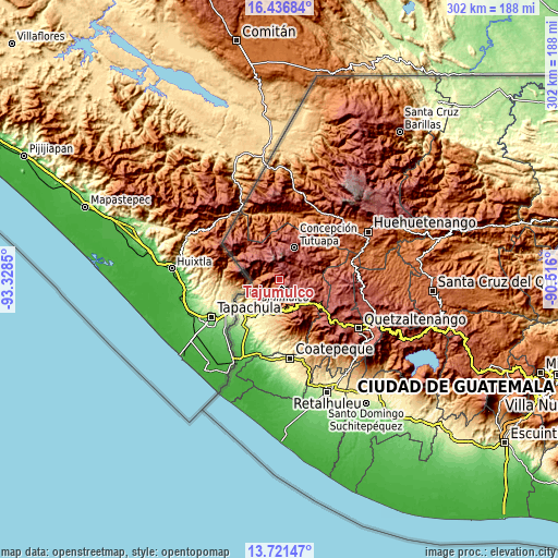
| \ | Map #1 | Map #2 | Topo.Map |
| Scale [m] | 1464..4208 m | 949..4208 m | × |
| Scale [ft] | 4803..13806 ft | 3114..13806 ft | × |
| Average | 2583.5 m = 8476 ft | 2516.5 m = 8256 ft | × |
| Width | 9.44 km = 5.9 mi | 18.87 km = 11.7 mi | 301.9 km = 187.6 mi |
| Height | 9.44 km = 5.9 mi | 18.87 km = 11.7 mi | 301.9 km = 187.6 mi |
| ↑Max Latitude | 15.125917° | 15.168336° | 16.43684° |
| Latitude at center | 15.08349° | 15.08349° | 15.08349° |
| ↓Min Latitude | 15.041054° | 14.998611° | 13.72147° |
| ← Min Longitude | -91.966195° | -92.010141° | -93.3285° |
| Longitude center | -91.92225° | -91.92225° | -91.92225° |
| →Max Longitude | -91.878305° | -91.834359° | -90.516° |
Nearby cities:
Cities around Tajumulco sort by population:
• San Marcos elevation 2380 m
19.1 km,  134°
134°
• Comitancillo 2271 m
18.5 km,  87°
87°
• San Pablo 617 m
18.9 km,  207°
207°
• San Rafael Pie de la Cuesta 1044 m
17 km,  176°
176°
• Tejutla 2481 m
13.2 km,  70°
70°
• Ixchiguán 3214 m
9 km,  352°
352°
• El Rodeo 693 m
19.7 km,  197°
197°
• Sibinal 2532 m
15.5 km,  298°
298°
• Esquipulas Palo Gordo 2475 m
18.9 km,  146°
146°
• San José Ojetenán 3254 m
15.6 km,  342°
342°
• Concepción Tutuapa 2922 m
19.2 km,  25°
25°
• San José Ojetenam 3056 m
17.7 km, 341°
Multilingual:
 En español:
Tajumulco elevación 2066 m.
 En France:
Tajumulco élévation 2066 m.
 Auf Deutsch:
Tajumulco höhe über dem Meeresspiegel ist 2066 m.

Sources and notes:
- [note 1] Map square and city borders are not equal. Map elevation data is calculated only from area inside that square.
- [src 1] Elevation data from geonames database provided with same terms of usage.
- [src 2] The elevation map of Tajumulco is generated using elevation data from NASA's 3 arcsec (90m) resolution SRTM data.
- [src 3] Base (background) map © OpenStreetMap contributors tiles are generated by Geofabrik and OpenTopoMap.
Copyright & License:
This Tajumulco Elevation Map is licensed under CC BY-SA. You may reuse any part from this page, if you give a proper credit by linking to this URL:
 More info on terms of use page.