Argos Orestiko elevation
Argos Orestiko (West Macedonia, Nomós Kastoriás), Greece elevation is 654 meters and Argos Orestiko elevation in feet is 2146 ft above sea level [src 1]. Argos Orestiko is a seat of a third-order administrative division (feature code) with elevation that is 503 meters (1650 ft) bigger than average city elevation in Greece.
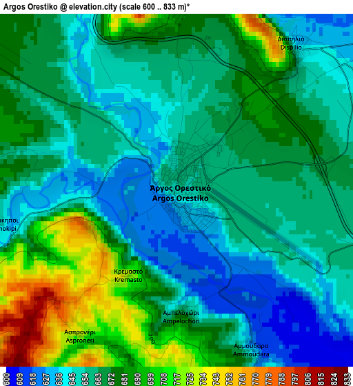
Below is the Elevation map of Argos Orestiko, which displays elevation range with different colors. Scale of the first map is from 600 to 833 m (1969 to 2733 ft) with average elevation of 667 meters (=2188 ft) [note 1]
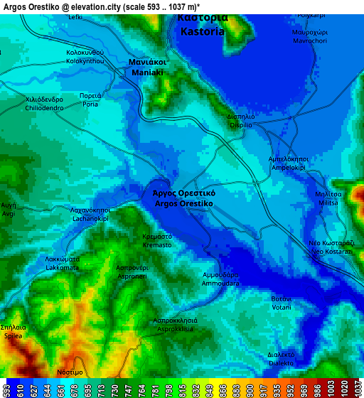
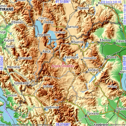
These maps also provides idea of topography and contour of this city, they are displayed at different zoom levels. More info about maps, scale and edge coordinates you can find below images.
| \ | Map #1 | Map #2 | Topo.Map |
| Scale [m] | 600..833 m | 593..1037 m | × |
| Scale [ft] | 1969..2733 ft | 1946..3402 ft | × |
| Average | 667 m = 2188 ft | 687.4 m = 2255 ft | × |
| Width | 7.44 km = 4.6 mi | 14.87 km = 9.2 mi | 238 km = 147.9 mi |
| Height | 7.44 km = 4.6 mi | 14.87 km = 9.2 mi | 237.9 km = 147.8 mi |
| ↑Max Latitude | 40.486971° | 40.520386° | 41.51506° |
| Latitude at center | 40.45354° | 40.45354° | 40.45354° |
| ↓Min Latitude | 40.420092° | 40.386628° | 39.37498° |
| ← Min Longitude | 21.214945° | 21.170999° | 19.85264° |
| Longitude center | 21.25889° | 21.25889° | 21.25889° |
| →Max Longitude | 21.302835° | 21.346781° | 22.66514° |
Nearby cities:
Cities around Argos Orestiko sort by population:
• Kastoria elevation 641 m
7.6 km,  2°
2°
• Chlói 645 m
9.5 km, 0°
• Maniákoi 663 m
5.4 km,  346°
346°
• Mesopotamía 694 m
9.9 km,  303°
303°
• Galatiní 1004 m
28.9 km,  120°
120°
• Tsotíli 837 m
22.1 km,  165°
165°
• Erátyra 767 m
24.8 km, 119°
• Mavrochóri 630 m
8.3 km,  38°
38°
• Anaráchi 715 m
26.9 km,  80°
80°
• Léchovo 882 m
24.5 km,  53°
53°
• Empório 691 m
25.6 km, 81°
• Nestório 865 m
17.3 km,  254°
254°
Multilingual:
 En español:
Argos Orestiko elevación 654 m.
 En France:
Argos Orestiko élévation 654 m.
 Auf Deutsch:
Argos Orestiko höhe über dem Meeresspiegel ist 654 m.

Sources and notes:
- [note 1] Map square and city borders are not equal. Map elevation data is calculated only from area inside that square.
- [src 1] Elevation data from geonames database provided with same terms of usage.
- [src 2] The elevation map of Argos Orestiko is generated using elevation data from NASA's 3 arcsec (90m) resolution SRTM data.
- [src 3] Base (background) map © OpenStreetMap contributors tiles are generated by Geofabrik and OpenTopoMap.
Copyright & License:
This Argos Orestiko Elevation Map is licensed under CC BY-SA. You may reuse any part from this page, if you give a proper credit by linking to this URL:
 More info on terms of use page.