Flórina elevation
Flórina (West Macedonia, Nomós Florínis), Greece elevation is 656 meters and Flórina elevation in feet is 2152 ft above sea level [src 1]. Flórina is a seat of a second-order administrative division (feature code) with elevation that is 505 meters (1657 ft) bigger than average city elevation in Greece.
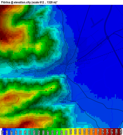
Below is the Elevation map of Flórina, which displays elevation range with different colors. Scale of the first map is from 612 to 1328 m (2008 to 4357 ft) with average elevation of 772.7 meters (=2535 ft) [note 1]
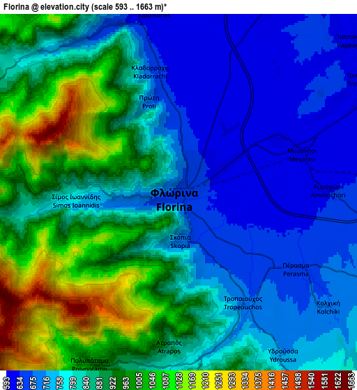
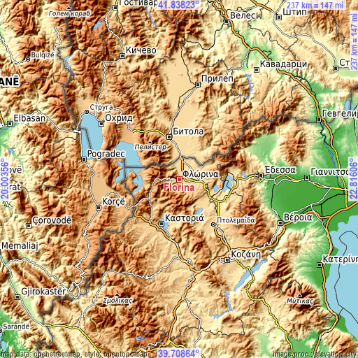
These maps also provides idea of topography and contour of this city, they are displayed at different zoom levels. More info about maps, scale and edge coordinates you can find below images.
| \ | Map #1 | Map #2 | Topo.Map |
| Scale [m] | 612..1328 m | 593..1663 m | × |
| Scale [ft] | 2008..4357 ft | 1946..5456 ft | × |
| Average | 772.7 m = 2535 ft | 845.9 m = 2775 ft | × |
| Width | 7.4 km = 4.6 mi | 14.8 km = 9.2 mi | 236.8 km = 147.1 mi |
| Height | 7.4 km = 4.6 mi | 14.8 km = 9.2 mi | 236.8 km = 147.1 mi |
| ↑Max Latitude | 40.815237° | 40.848487° | 41.83823° |
| Latitude at center | 40.78197° | 40.78197° | 40.78197° |
| ↓Min Latitude | 40.748686° | 40.715386° | 39.70864° |
| ← Min Longitude | 21.365865° | 21.321919° | 20.00356° |
| Longitude center | 21.40981° | 21.40981° | 21.40981° |
| →Max Longitude | 21.453755° | 21.497701° | 22.81606° |
Nearby cities:
Cities around Flórina sort by population:
• Kastoria elevation 641 m
31.5 km,  203°
203°
• Amýntaio 595 m
25 km,  114°
114°
• Chlói 645 m
29.8 km,  205°
205°
• Maniákoi 663 m
34.3 km, 204°
• Filótas 565 m
30.6 km,  124°
124°
• Melíti 671 m
15.8 km,  68°
68°
• Mavrochóri 630 m
30.9 km,  194°
194°
• Ammochóri 634 m
6.3 km,  89°
89°
• Léchovo 882 m
23 km,  162°
162°
• Xinó Neró 647 m
20.7 km, 119°
• Empório 691 m
34.9 km, 159°
• Laimós 910 m
23.4 km,  284°
284°
Multilingual:
 En español:
Florina elevación 656 m.
 En France:
Flórina élévation 656 m.


Sources and notes:
- [note 1] Map square and city borders are not equal. Map elevation data is calculated only from area inside that square.
- [src 1] Elevation data from geonames database provided with same terms of usage.
- [src 2] The elevation map of Flórina is generated using elevation data from NASA's 3 arcsec (90m) resolution SRTM data.
- [src 3] Base (background) map © OpenStreetMap contributors tiles are generated by Geofabrik and OpenTopoMap.
Copyright & License:
This Flórina Elevation Map is licensed under CC BY-SA. You may reuse any part from this page, if you give a proper credit by linking to this URL:
 More info on terms of use page.