Kateríni elevation
Kateríni (Central Macedonia, Nomós Pierías), Greece elevation is 40 meters and Kateríni elevation in feet is 131 ft above sea level [src 1]. Kateríni is a seat of a second-order administrative division (feature code) with elevation that is 111 meters (364 ft) smaller than average city elevation in Greece.
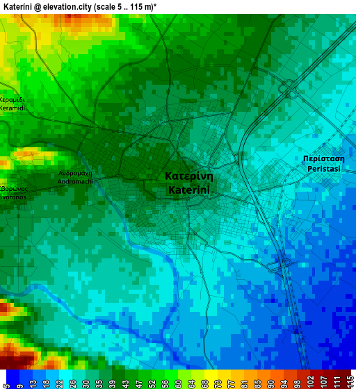
Below is the Elevation map of Kateríni, which displays elevation range with different colors. Scale of the first map is from 5 to 115 m (16 to 377 ft) with average elevation of 33.9 meters (=111 ft) [note 1]
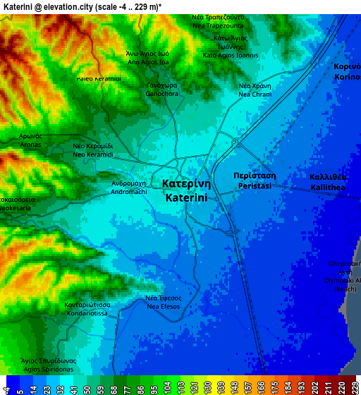
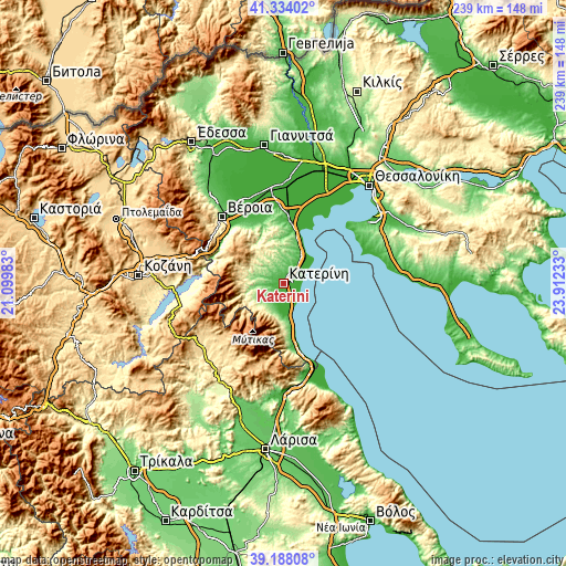
These maps also provides idea of topography and contour of this city, they are displayed at different zoom levels. More info about maps, scale and edge coordinates you can find below images.
| \ | Map #1 | Map #2 | Topo.Map |
| Scale [m] | 5..115 m | -4..229 m | × |
| Scale [ft] | 16..377 ft | -13..751 ft | × |
| Average | 33.9 m = 111 ft | 51.9 m = 170 ft | × |
| Width | 7.46 km = 4.6 mi | 14.91 km = 9.3 mi | 238.6 km = 148.3 mi |
| Height | 7.46 km = 4.6 mi | 14.91 km = 9.3 mi | 238.6 km = 148.3 mi |
| ↑Max Latitude | 40.303082° | 40.336588° | 41.33402° |
| Latitude at center | 40.26956° | 40.26956° | 40.26956° |
| ↓Min Latitude | 40.236021° | 40.202465° | 39.18808° |
| ← Min Longitude | 22.462135° | 22.418189° | 21.09983° |
| Longitude center | 22.50608° | 22.50608° | 22.50608° |
| →Max Longitude | 22.550025° | 22.593971° | 23.91233° |
Nearby cities:
Cities around Kateríni sort by population:
• Korinós elevation 12 m
8.7 km,  53°
53°
• Kallithéa 9 m
6.1 km,  85°
85°
• Perístasi 23 m
3.1 km,  79°
79°
• Karítsa 20 m
9.4 km,  192°
192°
• Vrontoú 122 m
10.5 km,  216°
216°
• Kontariótissa 44 m
6 km, 219°
• Svorónos 47 m
3.6 km,  267°
267°
• Néa Éfesos 20 m
4.5 km, 188°
• Paralía 3 m
7.6 km, 92°
• Lófos 244 m
11 km,  255°
255°
• Díon 30 m
11 km, 189°
• Ágios Spyrídon 65 m
8.7 km, 217°
Multilingual:
 En español:
Kateríni elevación 40 m.
 En France:
Kateríni élévation 40 m.


Sources and notes:
- [note 1] Map square and city borders are not equal. Map elevation data is calculated only from area inside that square.
- [src 1] Elevation data from geonames database provided with same terms of usage.
- [src 2] The elevation map of Kateríni is generated using elevation data from NASA's 3 arcsec (90m) resolution SRTM data.
- [src 3] Base (background) map © OpenStreetMap contributors tiles are generated by Geofabrik and OpenTopoMap.
Copyright & License:
This Kateríni Elevation Map is licensed under CC BY-SA. You may reuse any part from this page, if you give a proper credit by linking to this URL:
 More info on terms of use page.