Kavála elevation
Kavála (East Macedonia and Thrace, Nomós Kaválas), Greece elevation is 34 meters and Kavála elevation in feet is 112 ft above sea level [src 1]. Kavála is a seat of a second-order administrative division (feature code) with elevation that is 117 meters (384 ft) smaller than average city elevation in Greece.
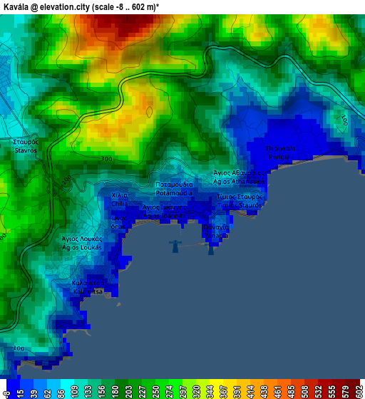
Below is the Elevation map of Kavála, which displays elevation range with different colors. Scale of the first map is from -8 to 602 m (-26 to 1975 ft) with average elevation of 177.1 meters (=581 ft) [note 1]
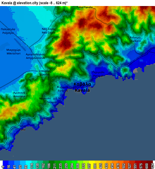
These maps also provides idea of topography and contour of this city, they are displayed at different zoom levels. More info about maps, scale and edge coordinates you can find below images.

| \ | Map #1 | Map #2 | Topo.Map |
| Scale [m] | -8..602 m | -8..624 m | × |
| Scale [ft] | -26..1975 ft | -26..2047 ft | × |
| Average | 177.1 m = 581 ft | 191.7 m = 629 ft | × |
| Width | 7.38 km = 4.6 mi | 14.76 km = 9.2 mi | 236.2 km = 146.8 mi |
| Height | 7.38 km = 4.6 mi | 14.76 km = 9.2 mi | 236.2 km = 146.8 mi |
| ↑Max Latitude | 40.972778° | 41.005949° | 41.99332° |
| Latitude at center | 40.93959° | 40.93959° | 40.93959° |
| ↓Min Latitude | 40.906385° | 40.873164° | 39.86878° |
| ← Min Longitude | 24.362925° | 24.318979° | 23.00062° |
| Longitude center | 24.40687° | 24.40687° | 24.40687° |
| →Max Longitude | 24.450815° | 24.494761° | 25.81312° |
Nearby cities:
Cities around Kavála sort by population:
• Eleftheroúpolis elevation 88 m
13.4 km,  257°
257°
• Néa Péramos 6 m
14.3 km,  218°
218°
• Krinídes 85 m
12.4 km,  311°
311°
• Amygdaleónas 72 m
4.7 km,  304°
304°
• Palaió Tsiflíki 16 m
6.1 km,  230°
230°
• Néa Karváli 5 m
9.1 km,  74°
74°
• Néa Iraklítsa 16 m
11.3 km, 222°
• Zygós 159 m
8.5 km,  345°
345°
• Kokkinóchoma 88 m
8.4 km, 260°
• Palaiochóri 213 m
19.3 km,  271°
271°
• Eleftherés 71 m
16.5 km, 231°
• Elaiochóri 81 m
19.1 km, 225°
Multilingual:
 En español:
Kavala elevación 34 m.
 En France:
Kavala élévation 34 m.


Sources and notes:
- [note 1] Map square and city borders are not equal. Map elevation data is calculated only from area inside that square.
- [src 1] Elevation data from geonames database provided with same terms of usage.
- [src 2] The elevation map of Kavála is generated using elevation data from NASA's 3 arcsec (90m) resolution SRTM data.
- [src 3] Base (background) map © OpenStreetMap contributors tiles are generated by Geofabrik and OpenTopoMap.
Copyright & License:
This Kavála Elevation Map is licensed under CC BY-SA. You may reuse any part from this page, if you give a proper credit by linking to this URL:
 More info on terms of use page.