Kozáni elevation
Kozáni (West Macedonia, Nomós Kozánis), Greece elevation is 713 meters and Kozáni elevation in feet is 2339 ft above sea level [src 1]. Kozáni is a seat of a first-order administrative division (feature code) with elevation that is 562 meters (1844 ft) bigger than average city elevation in Greece.
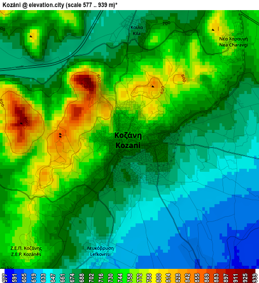
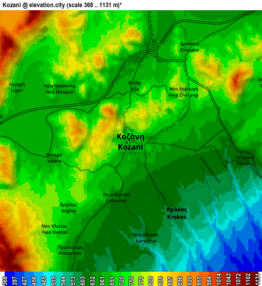
Below is the Elevation map of Kozáni, which displays elevation range with different colors. Scale of the first map is from 577 to 939 m (1893 to 3081 ft) with average elevation of 706.7 meters (=2319 ft) [note 1]
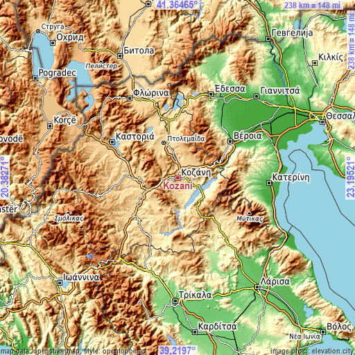
These maps also provides idea of topography and contour of this city, they are displayed at different zoom levels. More info about maps, scale and edge coordinates you can find below images.
| \ | Map #1 | Map #2 | Topo.Map |
| Scale [m] | 577..939 m | 368..1131 m | × |
| Scale [ft] | 1893..3081 ft | 1207..3711 ft | × |
| Average | 706.7 m = 2319 ft | 693.7 m = 2276 ft | × |
| Width | 7.45 km = 4.6 mi | 14.91 km = 9.3 mi | 238.5 km = 148.2 mi |
| Height | 7.45 km = 4.6 mi | 14.91 km = 9.3 mi | 238.5 km = 148.2 mi |
| ↑Max Latitude | 40.334197° | 40.367687° | 41.36465° |
| Latitude at center | 40.30069° | 40.30069° | 40.30069° |
| ↓Min Latitude | 40.267166° | 40.233626° | 39.2197° |
| ← Min Longitude | 21.745015° | 21.701069° | 20.38271° |
| Longitude center | 21.78896° | 21.78896° | 21.78896° |
| →Max Longitude | 21.832905° | 21.876851° | 23.19521° |
Nearby cities:
Cities around Kozáni sort by population:
• Siátista elevation 948 m
21.2 km,  258°
258°
• Sérvia 391 m
22 km,  127°
127°
• Krókos 601 m
4.8 km,  149°
149°
• Aianí 451 m
15.4 km,  170°
170°
• Galatiní 1004 m
20.2 km,  275°
275°
• Áno Kómi 453 m
8.9 km,  157°
157°
• Koíla 671 m
3.3 km,  3°
3°
• Erátyra 767 m
23.8 km, 281°
• Kleítos 700 m
15.7 km,  21°
21°
• Akriní 823 m
17.9 km,  33°
33°
• Platanórevma 474 m
22.9 km,  119°
119°
• Nea Lava 572 m
22.6 km, 122°
Multilingual:
 En español:
Kozani elevación 713 m.
 En France:
Kozani élévation 713 m.


Sources and notes:
- [note 1] Map square and city borders are not equal. Map elevation data is calculated only from area inside that square.
- [src 1] Elevation data from geonames database provided with same terms of usage.
- [src 2] The elevation map of Kozáni is generated using elevation data from NASA's 3 arcsec (90m) resolution SRTM data.
- [src 3] Base (background) map © OpenStreetMap contributors tiles are generated by Geofabrik and OpenTopoMap.
Copyright & License:
This Kozáni Elevation Map is licensed under CC BY-SA. You may reuse any part from this page, if you give a proper credit by linking to this URL:
 More info on terms of use page.