Orestiáda elevation
Orestiáda (East Macedonia and Thrace, Nomós Évrou), Greece elevation is 45 meters and Orestiáda elevation in feet is 148 ft above sea level [src 1]. Orestiáda is a seat of a third-order administrative division (feature code) with elevation that is 106 meters (348 ft) smaller than average city elevation in Greece.
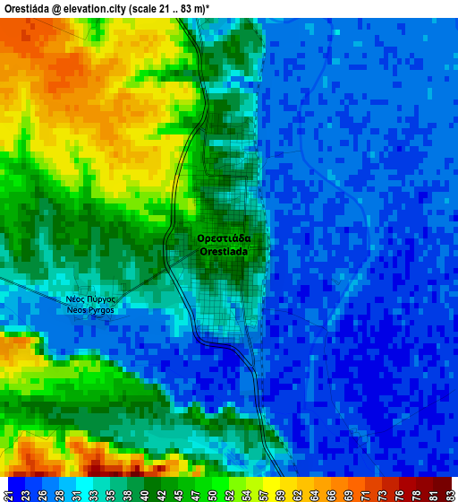
Below is the Elevation map of Orestiáda, which displays elevation range with different colors. Scale of the first map is from 21 to 83 m (69 to 272 ft) with average elevation of 36.6 meters (=120 ft) [note 1]
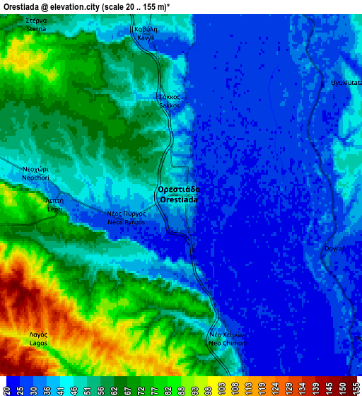
These maps also provides idea of topography and contour of this city, they are displayed at different zoom levels. More info about maps, scale and edge coordinates you can find below images.
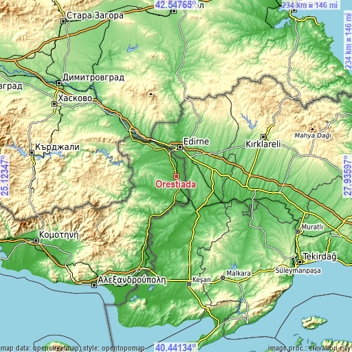
| \ | Map #1 | Map #2 | Topo.Map |
| Scale [m] | 21..83 m | 20..155 m | × |
| Scale [ft] | 69..272 ft | 66..509 ft | × |
| Average | 36.6 m = 120 ft | 49.4 m = 162 ft | × |
| Width | 7.32 km = 4.5 mi | 14.64 km = 9.1 mi | 234.2 km = 145.5 mi |
| Height | 7.32 km = 4.5 mi | 14.64 km = 9.1 mi | 234.2 km = 145.5 mi |
| ↑Max Latitude | 41.535963° | 41.56885° | 42.54765° |
| Latitude at center | 41.50306° | 41.50306° | 41.50306° |
| ↓Min Latitude | 41.47014° | 41.437203° | 40.44134° |
| ← Min Longitude | 26.485775° | 26.441829° | 25.12347° |
| Longitude center | 26.52972° | 26.52972° | 26.52972° |
| →Max Longitude | 26.573665° | 26.617611° | 27.93597° |
Nearby cities:
Cities around Orestiáda sort by population:
• Didymóteicho elevation 33 m
17.5 km,  189°
189°
• Souflí 36 m
39.6 km,  209°
209°
• Néa Výssa 33 m
9.1 km,  7°
7°
• Tycheró 37 m
56.3 km,  200°
200°
• Rízia 55 m
16 km,  327°
327°
• Lagós 104 m
8.2 km,  224°
224°
• Kavýli 33 m
6.7 km,  349°
349°
• Lávara 25 m
28.6 km, 204°
• Kastaniés 42 m
16.4 km,  344°
344°
• Neochóri 43 m
6.1 km,  278°
278°
• Kyprínos 69 m
26.3 km,  287°
287°
• Péplos 62 m
64.5 km, 199°
Multilingual:
 En español:
Orestiáda elevación 45 m.
 En France:
Orestiáda élévation 45 m.
 Auf Deutsch:
Orestiáda höhe über dem Meeresspiegel ist 45 m.

Sources and notes:
- [note 1] Map square and city borders are not equal. Map elevation data is calculated only from area inside that square.
- [src 1] Elevation data from geonames database provided with same terms of usage.
- [src 2] The elevation map of Orestiáda is generated using elevation data from NASA's 3 arcsec (90m) resolution SRTM data.
- [src 3] Base (background) map © OpenStreetMap contributors tiles are generated by Geofabrik and OpenTopoMap.
Copyright & License:
This Orestiáda Elevation Map is licensed under CC BY-SA. You may reuse any part from this page, if you give a proper credit by linking to this URL:
 More info on terms of use page.